অতি চমু উত্তৰ)
১. ভৌগোলিক অৱস্থানৰ এটা প্ৰধান বৈশিষ্ট্য উল্লেখ কৰা। [GU 2024]
উত্তৰ: ভৌগোলিক অৱস্থানৰ এটা মূল বৈশিষ্ট্য হ’ল— ই পৃথিৱীৰ পৃষ্ঠত কোনো পৰিঘটনা বা স্থানৰ সুনিৰ্দিষ্ট স্থানাংক (অক্ষাংশ আৰু দ্ৰাঘিমাংশ) বা আন কোনো ভৌগোলিক এককৰ সাপেক্ষে তাৰ স্থিতি নিৰ্ধাৰণ কৰে।
২. 'পৰম অৱস্থান' (Absolute Location) বুলিলে কি বুজা?
উত্তৰ: পৃথিৱীপৃষ্ঠত অক্ষাংশ (Latitude) আৰু দ্ৰাঘিমাংশৰ (Longitude) গাণিতিক স্থানাংক ব্যৱহাৰ কৰি নিৰ্ধাৰণ কৰা সুনির্দিষ্ট আৰু অপৰিৱৰ্তনীয় স্থানক পৰম অৱস্থান বোলে।
৩. 'আপেক্ষিক অৱস্থান' (Relative Location) কি?
উত্তৰ: আন এটা পৰিচিত ভৌগোলিক উপাদান, ভূ-চিহ্ন বা স্থানৰ দূৰত্ব আৰু দিশৰ সৈতে তুলনা কৰি প্ৰকাশ কৰা অৱস্থানক আপেক্ষিক অৱস্থান বোলে।
৪. স্থানিক বিজ্ঞানত 'বিন্দু প্ৰতিৰূপ' (Point Pattern) কি?
উত্তৰ: কোনো নিৰ্দিষ্ট ভৌগোলিক ক্ষেত্ৰত মানচিত্ৰৰ স্কেল অনুসৰি মাত্ৰাহীন বা একোটা বিন্দু (Point) হিচাপে চিহ্নিত কৰা উপাদানসমূহৰ (যেনে: বসতি, কুঁৱা) বিস্তাৰৰ বিন্যাসেই হ’ল বিন্দু প্ৰতিৰূপ।
৫. ৰৈখিক প্ৰতিৰূপৰ (Line Pattern) এটি উদাহৰণ দিয়া। [GU 2024]
উত্তৰ: নদী প্ৰণালী, ৰেলপথ বা ঘাইপথৰ নেটৱৰ্ক।
৬. ভৌগোলিক স্থানিক বিশ্লেষণত 'ক্ষেত্ৰীয় প্ৰতিৰূপ' (Area Pattern) কিহেৰে প্ৰকাশ কৰা হয়?
উত্তৰ: ক্ষেত্ৰীয় প্ৰতিৰূপ নিৰ্দিষ্ট সীমাৰেখাৰে আৱদ্ধ দ্বি-মাত্ৰিক বিস্তাৰযুক্ত অঞ্চল (Polygon), যেনে— অৰণ্য, কৃষিভূমি বা জলবায়ু মণ্ডলৰ জৰিয়তে প্ৰকাশ কৰা হয়।
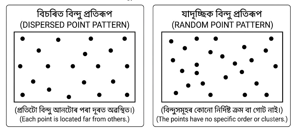
৭. বিন্দুৰ প্ৰতিৰূপ দেখুৱাই এটা চিত্র আঁকা। [GU 2024]
উত্তৰ:
২ নম্বৰীয়া প্ৰশ্ন (প্ৰতিটো প্ৰায় ৫০ শব্দৰ ভিতৰত) :
১. পৰম অৱস্থান আৰু আপেক্ষিক অৱস্থানৰ মাজৰ মূল পাৰ্থক্য লিখা।
উত্তৰ: পৰম অৱস্থান (Absolute Location) সদায় স্থিৰ আৰু অপৰিৱৰ্তনীয়, যি অক্ষাংশ-দ্ৰাঘিমাংশৰ জৰিয়তে নিৰূপণ কৰা হয় (যেনে: গুৱাহাটীৰ স্থানাংক ২৬°১১′ উত্তৰ, ৯১°৪৪′ পূব)। আনহাতে, আপেক্ষিক অৱস্থান (Relative Location) আন ভৌগোলিক উপাদানৰ সাপেক্ষে পৰিৱৰ্তনশীল (যেনে: ব্ৰহ্মপুত্ৰৰ দক্ষিণ পাৰে অৱস্থিত)।
২. ৰৈখিক প্ৰতিৰূপ (Line Pattern) কি? এটা উদাহৰণ দিয়া। [GU 2024]
উত্তৰ: কোনো ভৌগোলিক পৰিঘটনা যেতিয়া একমাত্ৰিক (One-dimensional) দিশত সৰলৰৈখিক বা বক্ৰাকাৰে বিস্তৃত হৈ থাকে, তাকে ৰৈখিক প্ৰতিৰূপ বোলে। ইয়াৰ দ্বাৰা স্থানৰ মাজত সংযোগ আৰু প্ৰবাহ প্ৰকাশ পায়। উদাহৰণস্বৰূপে— এটা মুখ্য ৰাষ্ট্ৰীয় ঘাইপথ বা নদীৰ কাষে কাষে গঢ় লৈ উঠা ৰৈখিক বসতি প্ৰতিৰূপ।
৩. বিন্দু প্ৰতিৰূপৰ মূল তিনিটা ধৰণ কি কি?
উত্তৰ: বিন্দু প্ৰতিৰূপ স্থানিক বিশ্লেষণত তিনিটা মুখ্য ধৰণত বিভক্ত:
পুঞ্জীভূত প্ৰতিৰূপ (Clustered Pattern): য’ত বিন্দুবোৰ একত্ৰিত হৈ কেন্দ্ৰীভূত হয়।
সম-বিতৰিত বা নিয়মীয়া প্ৰতিৰূপ (Regular/Uniform Pattern): য’ত বিন্দুবোৰ সমান দূৰত্বত অৱস্থিত।
বিক্ষিপ্ত বা যাদৃচ্ছিক প্ৰতিৰূপ (Random Pattern): কোনো নিৰ্দিষ্ট শৃংখলা নথকা বিস্তাৰ।
৪. স্থানিক বিশ্লেষণত 'ক্ষেত্ৰীয় প্ৰতিৰূপ' (Area/Areal Pattern) বুলিলে কি বুজা?
উত্তৰ: দ্বি-মাত্ৰিক স্থানিক বিস্তাৰ থকা আৰু নিৰ্দিষ্ট ভৌগোলিক পৰিসীমাৰে আবৃত অৱয়বসমূহৰ বিন্যাসকে ক্ষেত্ৰীয় প্ৰতিৰূপ বোলে। ই কোনো এক অঞ্চলৰ ভূমি ব্যৱহাৰ, প্ৰাকৃতিক উদ্ভিদৰ আৱৰণ বা প্ৰশাসনিক অঞ্চলৰ সমৰূপতা আৰু ভিন্নতা বিশ্লেষণ কৰাত ব্যৱহাৰ হয়।
৫. স্থানিক বিশ্লেষণত বিন্দু (Point), ৰেখা (Line) আৰু ক্ষেত্ৰৰ (Area) গুৰুত্ব কি?
উত্তৰ: এই তিনিটা উপাদান স্থানিক বিশ্লেষণ আৰু ভৌগোলিক তথ্য প্ৰণালীৰ (GIS) মূল ভেটি। বিন্দুক মাত্ৰাহীন (0-D) স্থিতি, ৰেখাক একমাত্ৰিক (1-D) সংযোগ বা প্ৰবাহ, আৰু ক্ষেত্ৰক দ্বি-মাত্ৰিক (2-D) আঞ্চলিক বিস্তাৰ প্ৰদৰ্শনৰ বাবে প্ৰতীক হিচাপে ব্যৱহাৰ কৰা হয়।
৬. স্থানিক সংগঠন (Spatial Organization) বুলিলে কি বুজা? [GU 2024]
উত্তৰ: পৃথিৱীপৃষ্ঠত ভৌগোলিক উপাদানসমূহ (মানৱীয় আৰু প্ৰাকৃতিক) যিদৰে শৃংখলাবদ্ধভাৱে সজ্জিত, আন্তঃসম্পৰ্কিত আৰু স্থানিক প্ৰক্ৰিয়াৰ জৰিয়তে কাৰ্যকৰী হৈ থাকে, সেই সমগ্ৰ গাঁথনিটোকে স্থানিক সংগঠন বোলে। ইয়াৰ দ্বাৰা অঞ্চল এটাৰ কাৰ্যপ্ৰণালী নিয়ন্ত্ৰিত হয়।
৭. ভৌগোলিক অৱস্থান বিশ্লেষণ কৰোঁতে 'স্থান' (Site) আৰু 'পৰিস্থিতি'ৰ (Situation) ভূমিকা কি?
উত্তৰ: 'স্থান' (Site) বুলিলে এটা ঠাইৰ ভৌতিক বা প্ৰাকৃতিক ভূ-প্ৰকৃতি, মাটি, জলবায়ু আদি অন্তৰ্নিহিত বৈশিষ্ট্যক বুজায়। আনহাতে, 'পৰিস্থিতি' (Situation) বুলিলে চৌপাশৰ অন্যান্য অঞ্চলৰ সৈতে থকা তাৰ কৌশলগত, সামাজিক আৰু অৰ্থনৈতিক সম্পৰ্কক বুজায়।
৫ নম্বৰীয়া প্ৰশ্ন (প্ৰতিটো প্ৰায় ২০০ শব্দৰ ভিতৰত) :
১. স্থানিক প্ৰক্ৰিয়াসমূহৰ ফলত কেনেকৈ স্থানিক প্ৰতিৰূপ গঢ় লয়, আলোচনা কৰা। [GU 2024]
উত্তৰ: ভূগোলত স্থানিক প্ৰতিৰূপ (Spatial Pattern) আৰু স্থানিক প্ৰক্ৰিয়া (Spatial Process) এটা আনটোৰ পৰিপূৰক। স্থানিক প্ৰক্ৰিয়া হ’ল সময়ৰ লগে লগে পৃথিৱীপৃষ্ঠত ঘটা পৰিঘটনা, চলাচল বা ক্ৰিয়া-কলাপ; আনহাতে স্থানিক প্ৰতিৰূপ হ’ল সেই প্ৰক্ৰিয়াৰ দৃশ্যমান ফল বা স্থানিক বিন্যাস।
প্ৰব্ৰজন আৰু নগৰীকৰণ প্ৰক্ৰিয়া: মানুহৰ কৰ্মসংস্থাপন আৰু উচ্চ শিক্ষাৰ বাবে হোৱা প্ৰব্ৰজনৰ ফলত নগৰাঞ্চলত জনসংখ্যাৰ পুঞ্জীভূত (Clustered) বিন্দু প্ৰতিৰূপ আৰু বসতিৰ উচ্চ ঘনত্ব গঢ় লৈ উঠে।
পৰিবহণ ব্যৱস্থাৰ সম্প্ৰসাৰণ: বাট-পথ আৰু ৰেলপথ নিৰ্মাণৰ ফলত সেই পথসমূহৰ কাষে কাষে অৰ্থনৈতিক কাৰ্যকলাপ আৰু বসতিৰ ৰৈখিক প্ৰতিৰূপ (Linear Pattern) বিকশিত হয়।
প্ৰাকৃতিক পৰিৱেশৰ প্ৰক্ৰিয়া: ভূ-প্ৰাকৃতিক গঠন, নদীৰ খনন-অৱক্ষেপণ কাৰ্য আৰু জলবায়ুৰ পৰিৱৰ্তনৰ ফলত কৃষিভূমি, অৰণ্য বা বানপীড়িত অঞ্চলৰ বিশেষ ক্ষেত্ৰীয় প্ৰতিৰূপ (Area Pattern) গঠন হয়।
অৰ্থাৎ, স্থানিক প্ৰক্ৰিয়াই হৈছে চালিকা শক্তি আৰু তাৰ ফলস্বৰূপে পৃথিৱীপৃষ্ঠত বিন্দু, ৰেখা আৰু ক্ষেত্ৰীয় বিন্যাসৰ প্ৰতিৰূপসমূহ স্থায়িত্ব পায়।
২. ভূগোলত অৱস্থানৰ ধাৰণা (Concept of Location) বহলাই আলোচনা কৰা।
উত্তৰ: অৱস্থান হ’ল স্থানিক বিজ্ঞান হিচাপে ভূগোলৰ প্ৰাথমিক আৰু অতি মৌলিক ধাৰণা। পৃথিৱীপৃষ্ঠৰ যিকোনো বস্তু বা পৰিঘটনা ক’ত অৱস্থিত— সেই প্ৰশ্নৰ উত্তৰ অৱস্থানৰ জৰিয়তে নিৰ্ণয় কৰা হয়। ভূগোলত অৱস্থানক মূলতঃ দুটা ভাগত ভাগ কৰা হয়:
১. পৰম অৱস্থান (Absolute Location): পৃথিৱীৰ গোলকীয় স্থানাংক ব্যৱস্থা অৰ্থাৎ অক্ষাংশ আৰু দ্ৰাঘিমাংশৰ দ্বাৰা কোনো স্থানৰ যি সুনিৰ্দিষ্ট স্থিতি নিৰ্ধাৰণ কৰা হয়, সেয়াই পৰম অৱস্থান। এই অৱস্থান বিশ্বব্যাপী অনন্য আৰু স্থিৰ। উদাহৰণস্বৰূপে, দিল্লীৰ পৰম অৱস্থান হ’ল ২৮°৩৮′ উত্তৰ অক্ষাংশ আৰু ৭৭°১২′ পূব দ্ৰাঘিমাংশ। আধুনিক GPS আৰু মানচিত্ৰ প্ৰস্তুতিত ইয়াৰ ভূমিকা অপৰিহাৰ্য।
২. আপেক্ষিক অৱস্থান (Relative Location): এটা ভৌগোলিক স্থানৰ আন এটা পৰিচিত স্থান, প্ৰাকৃতিক সীমা বা পৰিবহণ পথৰ সাপেক্ষে থকা দূৰত্ব আৰু দিশভিত্তিক স্থিতিক আপেক্ষিক অৱস্থান বোলে। এই অৱস্থান আন্তঃসংযোগ আৰু সামাজিক-অৰ্থনৈতিক পৰিৱৰ্তনৰ লগত সলনি হ’ব পাৰে। যেনে— "অসমখন পশ্চিমবংগৰ পূবত অৱস্থিত"।
ইয়াৰ উপৰিও অৱস্থানক প্ৰাকৃতিক ভৌতিক গুণাগুণযুক্ত 'Site' আৰু কৌশলগত সম্পৰ্কযুক্ত 'Situation' হিচাপেও বিশ্লেষণ কৰা হয়। মানৱীয় বিকাশ আৰু ভৌগোলিক আন্তঃক্ৰিয়া বুজিবলৈ অৱস্থানৰ ধাৰণা অত্যন্ত গুৰুত্বপূৰ্ণ।
৩. স্থানিক বিশ্লেষণত বিন্দু, ৰেখা আৰু ক্ষেত্ৰীয় প্ৰতিৰূপৰ ধাৰণা উপযুক্ত উদাহৰণসহ ব্যাখ্যা কৰা।
উত্তৰ: স্থানিক বিশ্লেষণত পৃথিৱীপৃষ্ঠৰ সকলো উপাদান আৰু পৰিঘটনাক তিনিটা জ্যামিতিক উপাদান— বিন্দু (Point), ৰেখা (Line) আৰু ক্ষেত্ৰ (Area) প্ৰতিৰূপৰ জৰিয়তে উপস্থাপন আৰু বিশ্লেষণ কৰা হয়:
১. বিন্দু প্ৰতিৰূপ (Point Pattern): মানচিত্ৰত মাত্ৰাহীন (Zero-dimensional) স্থানাংক হিচাপে চিহ্নিত কৰা উপাদানসমূহেই বিন্দু প্ৰতিৰূপ। ই পুঞ্জীভূত (যেনে: নগৰ কেন্দ্ৰ), নিয়মীয়া (যেনে: পৰিকল্পিত বজাৰ ব্যৱস্থা) বা যাদৃচ্ছিক (যেনে: প্ৰাকৃতিক গছ-গছনিৰ স্থিতি) হ’ব পাৰে।
২. ৰৈখিক প্ৰতিৰূপ (Line Pattern): যেতিয়া ভৌগোলিক উপাদান একমাত্ৰিক (One-dimensional) দিশত বিস্তৃত থাকে, তাক ৰৈখিক প্ৰতিৰূপ বোলে। ই প্ৰধানকৈ গতিশীলতা, প্ৰবাহ আৰু যোগাযোগ প্ৰকাশ কৰে। উদাহৰণস্বৰূপে— নদী উপত্যকা, বিদ্যুৎ পৰিবহণ লাইন, ৰেডিৱেল বা জালিকাযুক্ত পথ পৰিবহণ ব্যৱস্থা।
৩. ক্ষেত্ৰীয় প্ৰতিৰূপ (Area Pattern): নিৰ্দিষ্ট পৰিসীমাযুক্ত দ্বি-মাত্ৰিক (Two-dimensional) এলেকা বা বহুভুজক (Polygon) ক্ষেত্ৰীয় প্ৰতিৰূপ বোলে। ইয়াৰ দ্বাৰা অঞ্চলভিত্তিক সমৰূপতা প্ৰকাশ পায়। যেনে— কাজিৰঙা ৰাষ্ট্ৰীয় উদ্যানৰ এলেকা, চাহ বাগিচাৰ বিস্তাৰ বা কৃষি জলবায়ু অঞ্চল।
স্থানিক আৰ্হি আৰু GIS বিশ্লেষণত এই তিনিটা ধাৰণাৰ জৰিয়তে পৃথিৱীৰ জটিল বিন্যাসসমূহ বৈজ্ঞানিকভাৱে অধ্যয়ন কৰা হয়।
Very Short Answer)
1. Mention a characteristic of geographic location. [GU 2024]
Answer: A key characteristic of geographic location is that it defines the precise coordinates (latitude and longitude) or the position of a phenomenon relative to other spatial features on the Earth's surface.
2. What do you mean by 'Absolute Location'?
Answer: Absolute location refers to the exact, fixed, and unchanging position of a place on the Earth's surface determined by mathematical coordinates, specifically latitude and longitude.
3. What is 'Relative Location'?
Answer: Relative location refers to the position of a place or feature described in relation to other known landmarks, geographical entities, distance, or direction.
4. What is a 'Point Pattern' in spatial science?
Answer: A point pattern represents the spatial distribution and arrangement of individual geographic features that are abstracted as zero-dimensional points on a map (e.g., settlements, wells).
5. Give an example of a line pattern. [GU 2024]
Answer: A river drainage network, a railway corridor, or a highway transport network.
6. How is an 'Area Pattern' represented in geographic spatial analysis?
Answer: An area pattern is represented as a two-dimensional bounded spatial polygon depicting continuous phenomena, such as land-use zones, forest cover, or climatic belts.
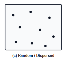
7. Draw a diagram to show point pattern. [GU 2024]
Answer:
2-Mark Questions :
1. Distinguish between absolute location and relative location.
Answer: Absolute location is fixed and mathematically defined using geographic coordinates (e.g., Guwahati at 26°11′ N, 91°44′ E). In contrast, relative location is dynamic and describes a site’s position with respect to surrounding features or connectivity (e.g., located along the southern bank of the Brahmaputra River).
2. What is line pattern? Give an example. [GU 2024]
Answer: A line pattern represents the linear or curvilinear arrangement of one-dimensional geographic features across space. It primarily illustrates connectivity, flow, and spatial networks. A classic example is a linear settlement pattern developed alongside a major national highway or river embankment.
3. What are the three primary types of point patterns?
Answer: Spatial analysis classifies point patterns into three primary configurations:
Clustered Pattern: Points are grouped closely together around central nodes.
Regular/Uniform Pattern: Points maintain an approximately equal distance from one another.
Random Pattern: Points are scattered without any identifiable spatial order or clustering.
4. What is meant by an 'Area Pattern' (Areal Pattern) in spatial analysis?
Answer: An area pattern describes the spatial distribution, extent, and internal variation of two-dimensional phenomena enclosed within defined geographic boundaries. Geographers use areal patterns to examine territorial homogeneity, regional land cover, agricultural belts, and administrative subdivisions.
5. What is the significance of Point, Line, and Area in spatial analysis?
Answer: Point, line, and area form the fundamental geometric primitives of cartographic modeling and Geographic Information Systems (GIS). Points represent zero-dimensional locations, lines denote one-dimensional flows and connections, and areas define two-dimensional zones of spatial extent and coverage.
6. What do you mean by the term 'Spatial Organization'? [GU 2024]
Answer: Spatial organization refers to the structural arrangement, integration, and operational functioning of natural and human elements across geographical space. It explains how spatial processes, interactions, and functional linkages bind individual locations into a coherent spatial system.
7. Differentiate between 'Site' and 'Situation' in the context of geographic location.
Answer: 'Site' refers to the internal physical characteristics and terrain attributes of an exact location, such as relief, soil quality, and water availability. 'Situation' describes a location's external spatial context, highlighting its accessibility, socioeconomic ties, and strategic advantages relative to other places.
5-Mark Questions (Around 200 Words Each) :
1. Explain how spatial patterns are formed as a result of spatial processes. [GU 2024]
Answer: In spatial science, spatial patterns and spatial processes are fundamentally interdependent. A spatial process represents the dynamic mechanism, movement, or human-environmental interaction operating over time, while a spatial pattern is the observable structural footprint or geometric outcome of that process on the Earth's surface.
- Migration and Urbanization: Human movements driven by industrialization and employment opportunities lead to urban agglomeration, generating dense, clustered point patterns of high-density settlements.
- Infrastructure Expansion: The diffusion of transport routes and communication channels channels economic activities along specific corridors, directly giving rise to linear settlement and commercial patterns.
- Environmental Processes: Natural dynamics such as fluvial erosion, sediment deposition, and micro-climatic gradients dictate the boundaries of fertile plains and floodplains, establishing distinct areal patterns of agriculture and forest reserves.
- Thus, spatial processes act as the driving forces that continuously mold, reinforce, and alter the spatial patterns across geographic space.
2. Discuss the concept of location in geography.
Answer: Location is the foundational concept of geography as a spatial science. It answers the fundamental geographical inquiry: "Where is it located?" In spatial analysis, location is evaluated through two distinct dimensions:
Absolute Location: This refers to an immutable, singular point on Earth determined through universal graticule coordinates (latitude and longitude). For example, New Delhi is situated at approximately 28°38′ N latitude and 77°12′ E longitude. Absolute location provides the geometric foundation for cartography, remote sensing, and Global Positioning Systems (GPS).
Relative Location: This describes the position of a geographic entity in relation to other physical landmarks, urban centers, or transportation routes. Unlike absolute location, relative location is dynamic and changes with modifications in transport connectivity and regional development (e.g., stating that "Assam lies east of West Bengal").
Geographers further expand location into the complementary concepts of Site (inherent physical attributes) and Situation (external functional connectivity). Mastering both dimensions is essential for analyzing spatial interactions, trade corridors, and regional development trajectories.
3. Explain the concepts of Point, Line, and Area patterns in spatial analysis with suitable examples.
Answer: Spatial analysis simplifies the real world into three core geometric primitives—points, lines, and areas—to map, quantify, and analyze spatial distributions:
- Point Pattern (Zero-Dimensional): Features where spatial extent is negligible at a given map scale are depicted as points. Point patterns reveal the dispersion, clustering, or randomness of features. Examples include the distribution of tubewells across an aquifer, urban central places, or retail outlets within a metropolis.
- Line Pattern (One-Dimensional): Linear features characterized by length and directional connectivity are represented as lines. Line analysis focuses on network density, routing efficiency, and flow dynamics. Key examples include river networks, railway corridors, power transmission grids, and highway networks.
- Area Pattern (Two-Dimensional): Continuous spatial phenomena bounded by identifiable perimeters are treated as areas or polygons. Areal patterns reflect spatial uniformity, regional zoning, and land classification. Examples include the territorial extent of Kaziranga National Park, tea cultivation belts, and agro-climatic zones.
Together, these three spatial primitives enable geographers and GIS specialists to model complex spatial structures and evaluate geographic phenomena scientifically.