অতি চমু প্ৰশ্নোত্তৰ (১ নম্বৰীয়া — ১৫ টা)
১. মহাসাগৰ বিজ্ঞান (Oceanography) মানে কি?
উত্তৰ: পৃথিৱীৰ মহাসাগৰ আৰু সাগৰসমূহৰ ভৌতিক, ৰাসায়নিক, ভূতাত্ত্বিক আৰু জৈৱিক বৈশিষ্ট্যসমূহৰ সামগ্ৰিক বৈজ্ঞানিক অধ্যয়নকেই মহাসাগৰ বিজ্ঞান বোলা হয়।
২. সমান লৱণতাযুক্ত ঠাইসমূহক সংযোগ কৰা কাল্পনিক ৰেখাডালক কি বোলে? [২০২৫]
উত্তৰ: সমলৱণ ৰেখা বা আইছোহেলাইন (Isohaline) বোলে।
৩. সমুদ্ৰৰ পানীত আটাইতকৈ অধিক পৰিমাণে পোৱা লৱণবিধৰ নাম কি?
উত্তৰ: ছডিয়াম ক্ল'ৰাইড (NaCl)।
৪. সাগৰীয় সোঁতৰ দিশ সলনি কৰা পৃথিৱীৰ আৱৰ্তনজনিত বলটোক কি বুলি জনা যায়?
উত্তৰ: কৰিঅ'লিছ বল (Coriolis Force)।
৫. সমুদ্ৰৰ গভীৰতাৰ সৈতে উষ্ণতা দ্ৰুতভাৱে হ্ৰাস পোৱা স্তৰটোক কি বোলে?
উত্তৰ: থাৰ্ম’ক্লাইন (Thermocline)।
৬. মহাসাগৰীয় পানীত লৱণতা বৃদ্ধিকাৰী এটা প্ৰধান কাৰক উল্লেখ কৰা। [২০২৫]
উত্তৰ: অতিমাত্ৰা বাষ্পীভৱন (বা নদীৰ বিশুদ্ধ পানীৰ কম আগমন)।
৭. এখন মহাসাগৰীয় অৱবাহিকা গঠনকাৰী প্ৰধান ভূতাত্ত্বিক প্লেট বা ফলকৰ উদাহৰণ দিয়া।
উত্তৰ: প্ৰশান্ত মহাসাগৰীয় ফলক (Pacific Plate)।
৮. লৱণতা জোখা সাধাৰণ এককটো কি?
উত্তৰ: প্ৰতি হাজাৰ ভাগত কেইভাগ বা PPT (Parts Per Thousand — ‰)।
৯. এটা প্ৰধান উষ্ণ সাগৰীয় সোঁতৰ নাম লিখা। [২০২৫]
উত্তৰ: উপসাগৰীয় সোঁত (Gulf Stream)।
১০. এটা প্ৰধান শীতল সাগৰীয় সোঁতৰ নাম লিখা। [২০২৫]
উত্তৰ: লেব্ৰাডৰ সোঁত (Labrador Current)।
১১. মহাসাগৰৰ তলিত নতুন ভূ-ত্বক সৃষ্টি হোৱা প্ৰক্ৰিয়াটোক কি বোলে?
উত্তৰ: সাগৰতলি প্ৰসাৰণ (Seafloor Spreading)।
১২. মুক্ত মহাসাগৰৰ গড় লৱণতা কিমান?
উত্তৰ: প্ৰায় ৩৫‰ (প্ৰতি হাজাৰত ৩৫ ভাগ)।
১৩. মহাদেশীয় প্ৰান্ত আৰু গভীৰ মহাসাগৰৰ মজিয়াক সংযোগ কৰা ঢালটোক কি বোলা হয়?
উত্তৰ: মহাদেশীয় ঢাল (Continental Slope)।
১৪. মহাসাগৰীয় জলপৃষ্ঠত বায়ুৰ ঘৰ্ষণৰ ফলত পানী এফালে গতি কৰা চক্ৰাকাৰ সোঁতৰ প্ৰণালীটোক কি বোলে?
উত্তৰ: জাইৰ (Gyre)।
১৫. সমুদ্ৰৰ গভীৰতাৰ সৈতে লৱণতা দ্ৰুতভাৱে সলনি হোৱা সংক্ৰমণ স্তৰটোক কি বোলে?
উত্তৰ: হেল’ক্লাইন (Halocline)।
২. চমু প্ৰশ্নোত্তৰ (৫০ শব্দৰ — ১৫ টা)
১. মহাসাগৰ বিজ্ঞান অধ্যয়নৰ অৰ্থ ব্যাখ্যা কৰা।
উত্তৰ: মহাসাগৰ বিজ্ঞান হৈছে হাইড্ৰ’স্ফিয়াৰ বা জলমণ্ডলৰ সামগ্ৰিক ভৌতিক, ৰাসায়নিক আৰু জৈৱিক পৰিঘটনাৰ বিশ্লেষণ। ই সাগৰীয় তৰংগ, সোঁত, সাগৰতলিৰ ভূ-প্ৰকৃতি, খনিজ সম্পদ আৰু জলবায়ুৰ সৈতে মহাসাগৰৰ নিবিড় আন্তঃসম্পৰ্ক বুজিবলৈ বিজ্ঞানসন্মতভাৱে সহায় কৰে।
২. সামুদ্ৰিক ভূগোলৰ তাৎপৰ্য বিষয়ে চমুকৈ লিখা। [২০২৫]
উত্তৰ: মহাসাগৰে পৃথিৱীৰ গোলকীয় জলবায়ু আৰু উষ্ণতা নিয়ন্ত্ৰণ কৰে। সামুদ্ৰিক ভূগোলে পৃথিৱীৰ খাদ্য সুৰক্ষা (মীন সম্পদ), সামুদ্ৰিক বাণিজ্য পথ, শক্তি সম্পদ (পেট্ৰ’লিয়াম আৰু জোৱাৰ শক্তি) আৰু শেহতীয়া জলবায়ু পৰিৱৰ্তনৰ প্ৰভাৱ অধ্যয়ন কৰাত এক অপৰিহাৰ্য ভূমিকা পালন কৰে।
৩. মহাসাগৰীয় দ্ৰোণী বা অৱবাহিকা সৃষ্টিত প্ৰভাৱ পেলোৱা দুটা প্ৰাথমিক ভূতাত্ত্বিক কাৰক কি কি? [২০২৫]
উত্তৰ: প্ৰধান কাৰক দুটা হৈছে—
ফলক সঞ্চাৰণ (Plate Tectonics): ফলকসমূহ পৰস্পৰৰ পৰা আঁতৰি গ’লে (Divergent) ভূ-ত্বকত ফাট মেলি নতুন অৱবাহিকা সৃষ্টি হয়।
সাগৰতলি প্ৰসাৰণ (Seafloor Spreading): মধ্য-মহাসাগৰীয় শৈলশিৰাৰ পৰা মেগমা ওলাই নতুন মহাসাগৰীয় খোলা গঠন কৰে।
৪. গৰম সাগৰীয় সোঁত আৰু শীতল সাগৰীয় সোঁতৰ পাৰ্থক্য লিখা। [২০২৫]
উত্তৰ: বিষুৱীয় বা উষ্ণমণ্ডলীয় অঞ্চলৰ পৰা মেৰু অঞ্চললৈ প্ৰবাহিত হোৱা অপেক্ষাকৃতভাৱে অধিক উষ্ণতাসম্পন্ন সোঁতক গৰম সোঁত বোলে (যেনে— গাল্ফ ষ্ট্ৰীম)। আনহাতে, মেৰু অঞ্চলৰ পৰা বিষুৱীয় অঞ্চললৈ বৈ অহা কম উষ্ণতাসম্পন্ন সোঁতক শীতল সোঁত বোলে (যেনে— লেব্ৰাডৰ সোঁত)।
৫. সমুদ্ৰৰ পানীৰ লৱণতা বুলিলে কি বুজা? [২০২৫]
উত্তৰ: সাগৰ বা মহাসাগৰৰ প্ৰতি ১,০০০ গ্ৰাম (১ কেজি) পানীত দ্ৰবীভূত হৈ থকা অজৈৱ লৱণৰ মুঠ পৰিমাণক (গ্ৰামত) সাগৰীয় লৱণতা বোলে। ইয়াৰ গড় মাত্ৰা ৩৫‰। সাগৰৰ পানীৰ ঘনত্ব আৰু চাপ নিয়ন্ত্ৰণত লৱণতাই মুখ্য ভূমিকা লয়।
৬. সাগৰীয় সোঁত সৃষ্টিত নিয়ত বতাহৰ ভূমিকা কি?
উত্তৰ: নিয়ত বতাহ (যেনে— বাণিজ্য বতাহ আৰু পশ্চিমা বতাহ) হৈছে সাগৰীয় পৃষ্ঠীয় সোঁত সৃষ্টিৰ প্ৰধান চালিকা শক্তি। এই বতাহবোৰে একে দিশত অবিৰতভাৱে বলি সাগৰৰ উপৰিভাগৰ পানীক ঘৰ্ষণ বলৰ জৰিয়তে নিজৰ গতিপথ অনুসৰি বহু দূৰলৈ ঠেলি লৈ যায়।
৭. মহাসাগৰীয় পানীত উষ্ণতা আৰু লৱণতাৰ মাজত কি সম্পৰ্ক আছে? [২০২৫]
উত্তৰ: উষ্ণতা বৃদ্ধি পালে বাষ্পীভৱনৰ হাৰ বাঢ়ে, যাৰ ফলত পানীত লৱণৰ ঘনত্ব বৃদ্ধি পায় (উচ্চ লৱণতা)। কিন্তু যিবোৰ উষ্ণ অঞ্চলত প্ৰচুৰ বৃষ্টিপাত হয় বা ডাঙৰ নদীৰ পানী পৰে, তাত উষ্ণতা বেছি হ’লেও লৱণতা তুলনামূলকভাৱে হ্ৰাস পায়।
৮. মধ্য-মহাসাগৰীয় শৈলশিৰা (Mid-Oceanic Ridge) কি?
উত্তৰ: মহাসাগৰৰ মজিয়াত দুটা টেকটনিক ফলক আঁতৰি যোৱাৰ ফলত ভূ-অভ্যন্তৰৰ পৰা লাভা ওলাই জমা হৈ সাগৰৰ তলত হাজাৰ হাজাৰ কিলোমিটাৰ দৈৰ্ঘ্যৰ একোটা নিমজ্জিত পৰ্বতমালা গঠন কৰে। ইয়াক মধ্য-মহাসাগৰীয় শৈলশিৰা বোলে, যেনে— মধ্য-আটলান্টিক শৈলশিৰা।
৯. থাৰ্ম’হেলাইন প্ৰচলন (Thermohaline Circulation) বুলিলে কি বুজা?
উত্তৰ: মহাসাগৰৰ পানীৰ উষ্ণতা (Thermo) আৰু লৱণতাৰ (Haline) তাৰতম্যৰ বাবে পানীৰ ঘনত্বৰ পৰিৱৰ্তন ঘটে। মেৰু অঞ্চলত ঠাণ্ডা আৰু বেছি লৱণযুক্ত গধুৰ পানী তললৈ বহি গভীৰ সাগৰেৰে বিষুৱীয় অঞ্চললৈ বৈ যোৱা গোলকীয় পৰিবহণ ব্যৱস্থাটোকে থাৰ্ম’হেলাইন প্ৰচলন বোলে।
১০. নদীৰ মোহনা অঞ্চলত লৱণতা কম হোৱাৰ কাৰণ কি?
উত্তৰ: নদীসমূহে স্থলভাগৰ পৰা বিশাল পৰিমাণৰ লৱণহীন বিশুদ্ধ পানী কঢ়িয়াই আনি সাগৰত পেলায়। এই নতুন মিঠা পানী সাগৰৰ লৱণযুক্ত পানীৰ সৈতে মিহলি হৈ সামগ্ৰিক ঘনত্ব পাতল কৰি পেলায়, যাৰ ফলত নদীৰ মোহনা অঞ্চলত লৱণতা যথেষ্ট কম থাকে।
১১. মহাসাগৰ বিজ্ঞানৰ পৰিসৰত অন্তৰ্ভুক্ত দুটা মূল শাখা কি কি?
উত্তৰ:
ভৌতিক মহাসাগৰ বিজ্ঞান (Physical Oceanography): সাগৰৰ উষ্ণতা, তৰংগ, জোৱাৰ-ভাটা আৰু সোঁতৰ অধ্যয়ন।
জৈৱিক মহাসাগৰ বিজ্ঞান (Biological Oceanography): সাগৰীয় পৰিৱেশত জীৱ আৰু উদ্ভিদৰ বিস্তাৰ আৰু বংশবৃদ্ধিৰ অধ্যয়ন।
১২. করিঅ’লিছ বলে মহাসাগৰীয় সোঁতক কেনেদৰে প্ৰভাৱিত কৰে?
উত্তৰ: পৃথিৱীৰ নিজ কক্ষত আৱৰ্তনৰ ফলত সৃষ্টি হোৱা বিক্ষেপক বলৰ বাবে সাগৰীয় সোঁত পোনপটীয়া ৰেখাত বৈ নাযায়। ফেৰেলৰ সূত্ৰ অনুসৰি এই বলে সোঁতক উত্তৰ গোলাৰ্ধত সোঁফালে আৰু দক্ষিণ গোলাৰ্ধত বাওঁফালে বেঁকা কৰি প্ৰবাহিত হ’বলৈ বাধ্য কৰে।
১৩. মহাসাগৰীয় অৱবাহিকাৰ গভীৰ খাদ (Ocean Trench) কি?
উত্তৰ: মহাসাগৰীয় খাদসমূহ হৈছে সাগৰৰ তলিৰ গভীৰতম আৰু ঠেক খাৱৈসদৃশ অংশ। যেতিয়া এটা মহাসাগৰীয় ফলক আন এটা ফলকৰ তলত প্ৰৱেশ কৰে (Subduction), তেতিয়া সীমান্তত এনে খাদৰ সৃষ্টি হয়, যেনে— মেৰিয়ানা খাদ।
১৪. মহাসাগৰীয় সোঁতৰ ওপৰত উপকূলৰ গঠনৰ প্ৰভাৱ কি?
উত্তৰ: সাগৰীয় সোঁত যেতিয়া মহাদেশীয় উপকূল বা কোনো দ্বীপপুঞ্জৰ সন্মুখীন হয়, তেতিয়া ই বাধা পাই নিজৰ মূল দিশ সলনি কৰে নাইবা দুটা বা ততোধিক শাখাত বিভক্ত হৈ উপকূলৰ দাঁতিয়েদি নতুন দিশত বৈ যায়।
১৫. মহাসাগৰ বিজ্ঞান অধ্যয়নে মানৱজাতিক কেনেদৰে সহায় কৰে?
উত্তৰ: এই অধ্যয়নে সাগৰীয় দুৰ্যোগ যেনে ছুনামী আৰু ঘূৰ্ণীবতাহৰ পূৰ্বানুমান কৰাত, মীন চিকাৰৰ উপযুক্ত অঞ্চল চিনাক্ত কৰাত, উপকূলীয় ক্ষয়ৰোধ ব্যৱস্থাপনা কৰাত আৰু সাগৰৰ পৰা নৱীকৰণযোগ্য শক্তি আহৰণ কৰাত মানুহক সহায় কৰে।
৩. ৰচনাধৰ্মী প্ৰশ্নোত্তৰ (২০০ শব্দৰ — ১০ টা)
১. মহাসাগৰ বিজ্ঞানৰ অৰ্থ, পৰিসৰ আৰু ইয়াৰ তাৎপৰ্য বহলাই আলোচনা কৰা। [২০২৫]
উত্তৰ: অৰ্থ: মহাসাগৰ বিজ্ঞান হৈছে পৃথিৱীৰ জলমণ্ডল অৰ্থাৎ সাগৰ-মহাসাগৰৰ সকলো ভৌতিক, ৰাসায়নিক, ভূতাত্ত্বিক আৰু জৈৱিক প্ৰক্ৰিয়াসমূহৰ প্ৰণালীবদ্ধ অধ্যয়ন। পৃথিৱীৰ পৃষ্ঠভাগৰ প্ৰায় ৭১ শতাংশ আৱৰি থকা জলৰাশিৰ ৰহস্য উদ্ঘাটন কৰাই এই বিজ্ঞানৰ মূল লক্ষ্য।
পৰিসৰ: মহাসাগৰ বিজ্ঞানৰ পৰিসৰ বহল আৰু আন্তঃশাখাভিত্তিক। ইয়াক মূলতঃ চাৰিটা ভাগত বিভক্ত কৰা হয়—
ভৌতিক মহাসাগৰ বিজ্ঞান: সাগৰীয় উষ্ণতা, ঘনত্ব, চাপ, তৰংগ, জোৱাৰ-ভাটা আৰু সোঁতৰ গতিবিধি অধ্যয়ন কৰে।
ৰাসায়নিক মহাসাগৰ বিজ্ঞান: সাগৰৰ পানীৰ ৰাসায়নিক গঠন, লৱণতা, দ্ৰৱীভূত গেছ আৰু প্ৰদূষণৰ মাত্ৰা বিশ্লেষণ কৰে।
ভূতাত্ত্বিক মহাসাগৰ বিজ্ঞান: মহাসাগৰীয় অৱবাহিকা, সাগৰতলিৰ ভূ-প্ৰকৃতি, প্লেট টেকটনিক্স আৰু পলস সঞ্চয়নৰ ইতিহাস অধ্যয়ন কৰে।
জৈৱিক মহাসাগৰ বিজ্ঞান: প্লেংকটনৰ পৰা আৰম্ভ কৰি বিশাল তিমি মাছলৈকে সাগৰীয় জীৱকুল আৰু তেওঁলোকৰ পৰিস্থিতিতন্ত্ৰ চালি-জাৰি চায়।
তাৎপৰ্য: বৰ্তমান গোলকীয় উষ্ণতা বৃদ্ধি আৰু জলবায়ু পৰিৱৰ্তনৰ সময়ত মহাসাগৰ বিজ্ঞানৰ তাৎপৰ্য অপৰিসীম। মহাসাগৰে পৃথিৱীৰ অতিৰিক্ত তাপ শোষণ কৰি জলবায়ু সুস্থিৰ ৰাখে। ইয়াৰ উপৰিও আন্তর্জাতিক বাণিজ্য পথ নিৰ্ধাৰণ, সামুদ্ৰিক খাদ্য সম্পদৰ অন্বেষণ, খনিজ আৰু খনিজ তেল আহৰণ তথা ছুনামী আৰু ঘূৰ্ণীবতাহৰ দৰে প্ৰাকৃতিক দুৰ্যোগৰ পূৰ্বানুমানত এই অধ্যয়ন অপৰিহাৰ্য।
২. মহাসাগৰীয় অৱবাহিকাৰ (Ocean Basin) উৎপত্তি আৰু গঠন সম্পৰ্কে ফলক সঞ্চাৰণ তত্ত্বৰ সহায়ত ব্যাখ্যা কৰা। [২০২৫]
উত্তৰ: মহাসাগৰীয় অৱবাহিকাসমূহ পৃথিৱীৰ সৃষ্টিৰ আৰম্ভণিৰ পৰা একে অৱস্থাত থকা নাই। আধুনিক ভূতত্ত্ব আৰু মহাসাগৰ বিজ্ঞান অনুসৰি 'ফলক সঞ্চাৰণ তত্ত্ব' (Plate Tectonics) আৰু 'সাগৰতলি প্ৰসাৰণ' (Seafloor Spreading) ধাৰণাৰ দ্বাৰা ইয়াৰ উৎপত্তি ব্যাখ্যা কৰা হয়।
পৃথিৱীৰ শিলামণ্ডল কেইবাটাও ডাঙৰ আৰু সৰু টেকটনিক ফলকত বিভক্ত। মহাসাগৰীয় অৱবাহিকাৰ সৃষ্টি মূলত তিনিটা প্ৰক্ৰিয়াৰ দ্বাৰা সম্পন্ন হয়:
অপসাৰী ফলক সীমা আৰু ফাট গঠন (Rifting): যেতিয়া দুটা ভূ-ত্বকীয় ফলক পৰস্পৰৰ পৰা বিপৰীত দিশত গতি কৰে, তেতিয়া মহাদেশীয় অংশত গভীৰ ফাট বা ৰিফ্ট উপত্যকাৰ সৃষ্টি হয় (যেনে— লোহিত সাগৰৰ প্ৰাৰম্ভিক অৱস্থা)। কালক্ৰমত এই ফাঁট বহল হৈ তাত সাগৰৰ পানী সোমাই অৱবাহিকা গঠন কৰে।
সাগৰতলিৰ প্ৰসাৰণ (Seafloor Spreading): হেৰী হেছে আগবঢ়োৱা ধাৰণা অনুসৰি, মধ্য-মহাসাগৰীয় শৈলশিৰাৰ ফাঁকেৰে ভূ-অভ্যন্তৰৰ গলিত লাভা অবিৰতভাৱে ওলাই আহি শীতল হয় আৰু দুয়োফালে নতুন মহাসাগৰীয় ভূ-ত্বক (Oceanic Crust) গঠন কৰে। ইয়াৰ ফলত অৱবাহিকাখন ক্ৰমান্বয়ে বহল হয় (যেনে— আটলান্টিক মহাসাগৰ)।
অভিসাৰী সীমা আৰু নিমজ্জন (Subduction): পুৰণি আৰু গধুৰ মহাসাগৰীয় ফলক যেতিয়া অন্য ফলকৰ তলত সোমাই যায়, তাত গভীৰ সামুদ্ৰিক খাদৰ সৃষ্টি হয় আৰু পুৰণি খোলাটো গলন ঘটে।
উইলছন চক্ৰৰ (Wilson Cycle) জৰিয়তে মহাসাগৰীয় অৱবাহিকাসমূহ লক্ষ লক্ষ বছৰ ধৰি সৃষ্টি, সম্প্ৰসাৰণ আৰু সংকোচনৰ মাজেৰে গতি কৰি থাকে।
৩. মহাসাগৰীয় সোঁতৰ উৎপত্তি আৰু গতিবিধি নিয়ন্ত্ৰণ কৰা প্ৰধান কাৰকসমূহ আলোচনা কৰা। [২০২৫]
উত্তৰ: মহাসাগৰীয় সোঁত হৈছে এক নিৰ্দিষ্ট দিশত বৃহৎ পৰিমাণৰ সাগৰীয় পানীৰ নিয়মীয়া আৰু অবিৰত অনুভূমিক প্ৰবাহ। এই সোঁতৰ উৎপত্তি আৰু গতি কোনো এটা কাৰকৰ ওপৰত নিৰ্ভৰ নকৰে, বৰঞ্চ কেইবাটাও আন্তঃসম্পৰ্কীয় কাৰকৰ ফলত ঘটে:
১. নিয়ত বতাহ (Planetary Winds): সোঁত সৃষ্টিৰ আটাইতকৈ মুখ্য কাৰক হৈছে নিয়ত বতাহ। বাণিজ্য বতাহ, পশ্চিমা বতাহ আৰু মেৰুদেশীয় বতাহে সাগৰৰ উপৰিভাগৰ পানীক ঘঁহি নিজৰ দিশত লৈ যায়। উদাহৰণস্বৰূপে, বাণিজ্য বতাহে বিষুৱীয় সোঁতসমূহক পূবৰ পৰা পশ্চিমলৈ ঠেলি দিয়ে।
২. পৃথিৱীৰ আৱৰ্তন আৰু কৰিঅ’লিছ বল (Earth's Rotation): পৃথিৱী পশ্চিমৰ পৰা পূবলৈ ঘূৰি থকাৰ বাবে কৰিঅ’লিছ বলৰ সৃষ্টি হয়। এই বলে সোঁতৰ গতিপথক উত্তৰ গোলাৰ্ধত সোঁফালে আৰু দক্ষিণ গোলাৰ্ধত বাওঁফালে বিক্ষেপিত কৰে, যাৰ ফলত বৃত্তাকাৰ জাইৰ (Gyre) গঠন হয়।
৩. সাগৰৰ পানীৰ ঘনত্বৰ পাৰ্থক্য (Density Difference): উষ্ণতা আৰু লৱণতাৰ তাৰতম্যৰ বাবে পানীৰ ঘনত্ব বেলেগ হয়। বিষুৱীয় অঞ্চলৰ উষ্ণ আৰু পাতল পানী উপৰিভাগেৰে মেৰুৰ দিশে বয় আৰু মেৰু অঞ্চলৰ অতি শীতল, গধুৰ পানী সাগৰৰ তলেৰে বিষুৱৰেখাৰ দিশে প্ৰৱাহিত হয়।
৪. উপকূলৰ আকৃতি আৰু সাগৰতলিৰ ভূ-প্ৰকৃতি: সোঁতৰ গতিপথত মহাদেশ বা দ্বীপপুঞ্জে বাধা দিলে সোঁতৰ দিশ সলনি হয়। যেনে— দক্ষিণ আমেৰিকাৰ ছেইণ্ট ৰোক অন্তৰীপত খুন্দা খাই দক্ষিণ বিষুৱীয় সোঁতটো দুটা ভাগত বিভক্ত হয়।
৪. পৃথিৱীৰ মহাসাগৰসমূহত লৱণতাৰ আনুভূমিক আৰু উলম্ব বিতৰণ আলোচনা কৰা। [২০২৫]
উত্তৰ: মহাসাগৰৰ লৱণতা সকলো ঠাইতে একে নহয়; স্থানীয় বাষ্পীভৱন, বৰষুণ আৰু নদীৰ পানীৰ আগমনৰ ওপৰত নিৰ্ভৰ কৰি ইয়াৰ বিতৰণ ভিন্ন হয়।
১. আনুভূমিক বিতৰণ (Horizontal Distribution):
বিষুৱীয় অঞ্চল: যদিও এই অঞ্চলত উষ্ণতা বেছি, তথাপি প্ৰতিদিনে হোৱা প্ৰচুৰ বৃষ্টিপাত আৰু ডাৱৰীয়া আকাশৰ বাবে বাষ্পীভৱন নিয়ন্ত্ৰিত থাকে। সেয়েহে ইয়াত লৱণতা মধ্যমীয়া (প্ৰায় ৩৪‰-৩৫‰)।
ক্ৰান্তীয় অঞ্চল (২০° ৰ পৰা ৩০° উত্তৰ আৰু দক্ষিণ): এই অঞ্চলত উচ্চ উষ্ণতা, শুকান বায়ু আৰু প্ৰবল বাষ্পীভৱনৰ বিপৰীতে বৰষুণ অতি কম হয়। সেয়েহে এই অঞ্চলত সৰ্বাধিক লৱণতা (৩৬‰-৩৭‰) দেখা যায়।
মেৰু অঞ্চল: কম বাষ্পীভৱন আৰু বৰফ গলা মিঠা পানী মিহলি হোৱাৰ বাবে মেৰু অঞ্চলত লৱণতা যথেষ্ট কম (২০‰-৩২‰)।
২. উলম্ব বিতৰণ (Vertical Distribution):
পৃষ্ঠীয় স্তৰ (Surface Layer): ওপৰৰ প্ৰায় ১০০-২০০ মিটাৰ স্তৰত সূৰ্যৰ তাপ, বতাহ আৰু বাষ্পীভৱনৰ প্ৰভাৱত লৱণতা স্থানীয় পৰিৱেশ অনুসৰি ভিন্ন হয়।
হেল’ক্লাইন স্তৰ (Halocline): ৩০০ মিটাৰৰ পৰা ১০০০ মিটাৰ গভীৰতাৰ মাজৰ এই স্তৰটোত গভীৰতা বৃদ্ধিৰ সৈতে লৱণতাৰ মাত্ৰা অতি দ্ৰুতগতিত সলনি হয়।
গভীৰ স্তৰ (Deep Ocean): ১০০০ মিটাৰৰ তলত মহাসাগৰৰ লৱণতা প্ৰায় স্থিৰ (৩৪.৫‰ ৰ পৰা ৩৫‰) হৈ থাকে, কাৰণ বাহ্যিক বায়ুমণ্ডলীয় কাৰকে এই গভীৰতাত বিশেষ প্ৰভাৱ পেলাব নোৱাৰে।
৫. মহাসাগৰৰ উষ্ণতা আৰু লৱণতাৰ মাজৰ পাৰস্পৰিক সম্পৰ্ক আৰু ইয়াৰ প্ৰভাৱ বিশ্লেষণ কৰা। [২০২৫]
উত্তৰ: মহাসাগৰীয় জলবিজ্ঞানত উষ্ণতা আৰু লৱণতা দুয়োটা অতি গুৰুত্বপূৰ্ণ চলক, যিয়ে একেলগে সাগৰৰ পানীৰ ভৌতিক চৰিত্ৰ তথা ঘনত্ব নিৰ্ধাৰণ কৰে।
পাৰস্পৰিক সম্পৰ্ক:
উষ্ণতা বৃদ্ধি পালে পানীৰ অণুসমূহ প্ৰসাৰিত হয় আৰু বাষ্পীভৱনৰ হাৰ বৃদ্ধি পায়। কেৱল বিশুদ্ধ পানী বাষ্পীভূত হৈ বায়ুমণ্ডললৈ যোৱাৰ ফলত অৱশিষ্ট পানীত লৱণৰ ঘনত্ব বৃদ্ধি পায়। গতিকে দেখা যায় যে উষ্ণ আৰু শুকান ক্ৰান্তীয় অঞ্চলত লৱণতা সৰ্বাধিক।
কিন্তু য’ত উষ্ণতাৰ লগতে বৰষুণৰ পৰিমাণ বেছি, তাত নতুনকৈ জমা হোৱা বিশুদ্ধ পানীয়ে লৱণতা কমাই ৰাখে। বিপৰীতভাৱে, শীতল মেৰু অঞ্চলত যেতিয়া সাগৰৰ পানী গোট মাৰি বৰফ (Sea ice) হয়, তেতিয়া বৰফত লৱণ সোমাই নাথাকে; লৱণখিনি ওচৰৰ পানীত এৰি দিয়ে। ফলত অতি শীতল আৰু অধিক লৱণযুক্ত পানীৰ সৃষ্টি হয়।
প্ৰভাৱ:
ঘনত্ব নিৰ্ধাৰণ: শীতল আৰু অধিক লৱণযুক্ত পানী আটাইতকৈ বেছি গধুৰ (ঘন) হয়।
গোলকীয় জলপ্ৰবাহ: মেৰু অঞ্চলৰ এই গধুৰ পানী সাগৰৰ তলিৰে বিষুৱৰেখাৰ পিনে বয় আৰু মহাসাগৰীয় কনভেয়ৰ বেল্ট (Conveyor Belt) সক্ৰিয় ৰাখে।
সামুদ্ৰিক জীৱ: উষ্ণতা আৰু লৱণতাৰ এই পাৰস্পৰিক ভাৰসাম্যই সাগৰৰ বিভিন্ন স্তৰত পুষ্টিদ্ৰব্যৰ সঞ্চালন ঘটাই সামুদ্ৰিক উদ্ভিদ আৰু জীৱকুলৰ জীৱনধাৰণ সম্ভৱ কৰি তোলে।
৬. বিভিন্ন প্ৰকাৰৰ মহাসাগৰীয় সোঁতসমূহৰ শ্ৰেণীবিভাজন উপযুক্ত উদাহৰণসহ আলোচনা কৰা। [২০২৫]
উত্তৰ: মহাসাগৰীয় সোঁতসমূহক মূলতঃ উষ্ণতা, গভীৰতা আৰু প্ৰকৃতিৰ ভিত্তিত শ্ৰেণীবিভাজন কৰা হয়:
১. উষ্ণতাৰ ভিত্তিত শ্ৰেণীবিভাজন:
উষ্ণ সাগৰীয় সোঁত (Warm Currents): যিবোৰ সোঁত তুলনামূলকভাৱে গৰম অঞ্চলৰ পৰা (বিষুৱীয় অঞ্চল) শীতল অঞ্চললৈ (মেৰু অঞ্চল) প্ৰবাহিত হয়, সেইবোৰক উষ্ণ সোঁত বোলে। এই সোঁতে উপকূলীয় অঞ্চলৰ উষ্ণতা বৃদ্ধি কৰে।
উদাহৰণ: গাল্ফ ষ্ট্ৰীম (Gulf Stream), কুৰোছিঅ’ সোঁত (Kuroshio Current)।
শীতল সাগৰীয় সোঁত (Cold Currents): যিবোৰ সোঁত মেৰু বা উচ্চ অক্ষাংশৰ পৰা নিম্ন অক্ষাংশৰ বিষুৱীয় অঞ্চললৈ বৈ আহে, সেইবোৰক শীতল সোঁত বোলে। ই উপকূলীয় অঞ্চল শীতল আৰু শুকান কৰি ৰাখে।
উদাহৰণ: লেব্ৰাডৰ সোঁত (Labrador Current), পেৰু বা হামবোল্ড সোঁত (Peru Current)।
২. গভীৰতা আৰু বেগৰ ভিত্তিত শ্ৰেণীবিভাজন:
পৃষ্ঠীয় সোঁত (Surface Currents): মহাসাগৰৰ উপৰিভাগৰ পৰা প্ৰায় ৪০০ মিটাৰ গভীৰতালৈকে প্ৰবাহিত হোৱা পানী। ই মুঠ মহাসাগৰীয় পানীৰ মাত্ৰ ১০% অংশহে গঠন কৰে যদিও অতি দ্ৰুতবেগী।
গভীৰ জলপ্ৰবাহ (Deep Ocean Currents): ৪০০ মিটাৰৰ পৰা সাগৰতলি পৰ্যন্ত ঘনত্বৰ তাৰতম্যৰ বাবে অতি ধীৰ গতিত বৈ থকা বিশাল জলপ্ৰবাহ (Thermohaline circulation)। ই মহাসাগৰৰ ৯০% পানী কঢ়িয়ায়।
৩. আকৃতি আৰু আকাৰৰ ভিত্তিত: ড্ৰিফ্ট (ধীৰ গতিৰ প্ৰবাহ, যেনে— উত্তৰ আটলান্টিক ড্ৰিফ্ট) আৰু ষ্ট্ৰীম (নিৰ্দিষ্ট সীমাতে বৈ থকা দ্ৰুত প্ৰবাহ, যেনে— গাল্ফ ষ্ট্ৰীম)।
৭. মহাসাগৰীয় জলৰাশিৰ উলম্ব স্তৰবিন্যাস (Vertical Stratification) চিত্ৰকল্প আৰু ব্যাখ্যা আগবঢ়োৱা।
উত্তৰ: উষ্ণতা, লৱণতা আৰু ঘনত্বৰ তাৰতম্যৰ ভিত্তিত মহাসাগৰৰ পানীক পৃষ্ঠভাগৰ পৰা সাগৰতলিলৈকে তিনিটা প্ৰধান স্তৰত ভাগ কৰা হয়:
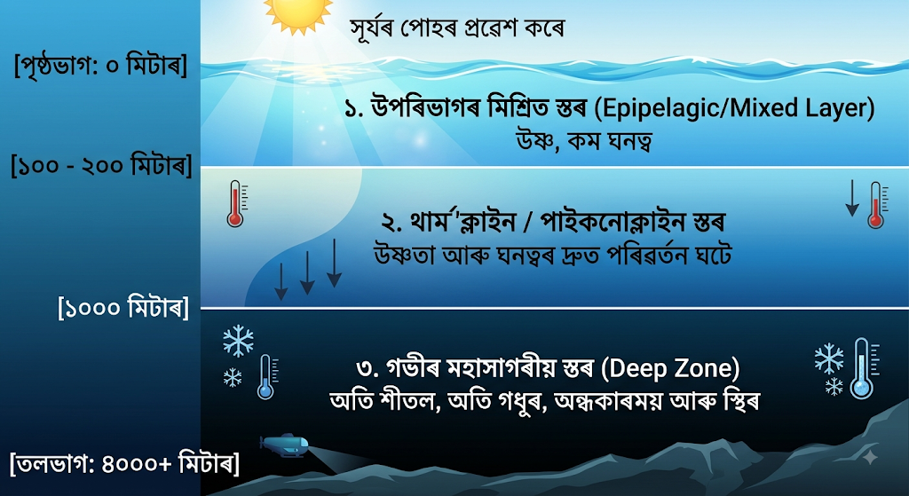
উপৰিভাগৰ মিশ্ৰিত স্তৰ (Surface / Mixed Layer): এইটো সাগৰৰ আটাইতকৈ ওপৰৰ স্তৰ, যাৰ গভীৰতা প্ৰায় ১০০ ৰ পৰা ২০০ মিটাৰ। সূৰ্যৰ পোহৰ পোনে পোনে পৰাৰ বাবে ই আটাইতকৈ উষ্ণ আৰু বতাহ-ঢৌৰ দ্বাৰা পানী মিহলি হৈ থাকে বাবে ইয়াৰ উষ্ণতা আৰু লৱণতা প্ৰায় সমৰূপ হয়। সালোক সংশ্লেষণৰ বাবে সাগৰীয় জীৱ ইয়াত সৰ্বাধিক।
সংক্ৰমণ স্তৰ বা থাৰ্ম’ক্লাইন (Thermocline Layer): ২০০ মিটাৰৰ পৰা প্ৰায় ১,০০০ মিটাৰ গভীৰতালৈ এই স্তৰটো বিস্তৃত। ইয়াত গভীৰতা বঢ়াৰ লগে লগে পানীৰ উষ্ণতা অতি দ্ৰুতভাৱে হ্ৰাস পায়। একেদৰে ঘনত্ব দ্ৰুতভাৱে বঢ়া অংশক পাইকনোক্লাইন (Pycnocline) আৰু লৱণতা সলনি হোৱা অংশক হেল’ক্লাইন (Halocline) বোলে।
গভীৰ শীতল স্তৰ (Deep Ocean Zone): ১,০০০ মিটাৰ গভীৰতাৰ পৰা একেবাৰে সাগৰৰ তলি পৰ্যন্ত এই স্তৰ বিস্তৃত। ইয়াত সূৰ্যৰ পোহৰ একেবাৰে নোসোমায়। পানীৰ উষ্ণতা মাত্ৰ ০° ৰ পৰা ৩° চেলছিয়াছৰ ভিতৰত থাকে আৰু ই অতিশয় গধুৰ ও স্থিৰ।
৮. মহাসাগৰীয় সোঁতে উপকূলীয় অঞ্চলৰ জলবায়ু আৰু মানৱ অৰ্থনীতিত কেনে প্ৰভাৱ পেলায়?
উত্তৰ: মহাসাগৰীয় সোঁত হৈছে গোলকীয় তাপ বিতৰণৰ এক প্ৰধান মাধ্যম। ই উপকূলীয় অঞ্চলৰ প্ৰাকৃতিক পৰিৱেশ আৰু অৰ্থনীতিত গভীৰ প্ৰভাৱ পেলায়:
১. জলবায়ুৰ ওপৰত প্ৰভাৱ:
উষ্ণতা নিয়ন্ত্ৰণ: উষ্ণ সোঁতে কাষৰীয়া উপকূলীয় অঞ্চলক তুলনামূলকভাৱে উষ্ণ কৰি ৰাখে। উদাহৰণস্বৰূপে, উত্তৰ আটলান্টিক ড্ৰিফ্টৰ উষ্ণ প্ৰভাৱৰ বাবে উচ্চ অক্ষাংশত অৱস্থিত হোৱা সত্ত্বেও উত্তৰ-পশ্চিম ইউৰোপ আৰু ব্ৰিটেইনৰ বন্দৰসমূহ শীতকালতো বৰফমুক্ত হৈ থাকে।
মৰুভূমি সৃষ্টি: শীতল সোঁত বৈ যোৱা উপকূলীয় অঞ্চলৰ বতাহ শুকান আৰু স্থিৰ হয়, যাৰ ফলত বৰষুণ নহয়। পৃথিৱীৰ বহুতো প্ৰধান মৰুভূমি শীতল সোঁতৰ কাষতে অৱস্থিত (যেনে— বেংগুৱেলা শীতল সোঁতৰ বাবে কালাহাৰী মৰুভূমি আৰু পেৰু সোঁতৰ বাবে আটাকামা মৰুভূমি)।
২. মানৱ অৰ্থনীতিত প্ৰভাৱ:
মীন পালন ক্ষেত্ৰ (Fishing Grounds): য’ত উষ্ণ আৰু শীতল সোঁতৰ মিলন ঘটে, তাত সাগৰীয় প্লাংকটনৰ (Plankton) প্ৰচুৰ বৃদ্ধি হয়। এই অঞ্চলবোৰ পৃথিৱীৰ বিখ্যাত মীন চিকাৰ কেন্দ্ৰ হিচাপে গঢ়ি উঠিছে। যেনে— গাল্ফ ষ্ট্ৰীম আৰু লেব্ৰাডৰ সোঁতৰ মিলনস্থল নিউফাউণ্ডলেণ্ডৰ 'গ্ৰেণ্ড বেংকছ'।
নৌ-পৰিবহণ: সোঁতৰ দিশ অনুসৰি জাহাজ চলাচল কৰিলে ইন্ধন আৰু সময় ৰাহি হয়। কিন্তু উষ্ণ আৰু শীতল সোঁতৰ মিলনস্থলত সৃষ্টি হোৱা ঘন কুঁৱলীয়ে জাহাজ চলাচলত বিপদৰো সৃষ্টি কৰে।
৯. ভূমধ্যসাগৰ আৰু বাল্টিক সাগৰৰ লৱণতাৰ তাৰতম্যৰ কাৰণসমূহ বিশ্লেষণ কৰা।
উত্তৰ: আৱদ্ধ বা প্ৰান্তীয় সাগৰসমূহত ভৌগোলিক অৱস্থান আৰু জলবায়ুৰ পাৰ্থক্যৰ বাবে লৱণতাৰ মাত্ৰাত নাটকীয় পাৰ্থক্য দেখা যায়। ইয়াৰ এক উৎকৃষ্ট উদাহৰণ হৈছে ভূমধ্যসাগৰ (উচ্চ লৱণতা) আৰু বাল্টিক সাগৰ (নিম্ন লৱণতা)।
১. ভূমধ্যসাগৰৰ উচ্চ লৱণতা (প্ৰায় ৩৮‰ - ৩৯‰):
উচ্চ বাষ্পীভৱন: ভূমধ্যসাগৰ উপ-ক্ৰান্তীয় অঞ্চলত অৱস্থিত হোৱাৰ বাবে ইয়াত বছৰৰ বেছিভাগ সময় প্ৰখৰ ৰ’দ আৰু উষ্ণ জলবায়ু বিৰাজ কৰে, যাৰ ফলত বাষ্পীভৱনৰ হাৰ অতি বেছি।
সীমিত মিঠা পানীৰ আগমন: এই সাগৰত পতিত হোৱা নদীৰ সংখ্যা কম আৰু বৰষুণৰ পৰিমাণো সীমিত।
আৱদ্ধ প্ৰকৃতি: জিব্ৰাল্টাৰ প্ৰণালীৰ সংকীৰ্ণ মুখেৰে আটলান্টিকৰ লগত যুক্ত হৈ থকা বাবে মুক্ত মহাসাগৰৰ সৈতে পানীৰ সহজে আদান-প্ৰদান হ’ব নোৱাৰে।
২. বাল্টিক সাগৰৰ নিম্ন লৱণতা (প্ৰায় ৭‰ - ১৫‰ বা তাতকৈও কম):
কম বাষ্পীভৱন: উচ্চ অক্ষাংশত অৱস্থিত হোৱাৰ বাবে বাল্টিক সাগৰৰ জলবায়ু অতি শীতল আৰু বাষ্পীভৱনৰ মাত্ৰা নগণ্য।
বিশাল পৰিমাণৰ নদীৰ পানী: অসংখ্য বৰফ গলা নদী আৰু জলধাৰাই বছৰটোৰ সকলো সময়তে বাল্টিক সাগৰত বৃহৎ পৰিমাণৰ বিশুদ্ধ মিঠা পানী যোগান ধৰে।
বৰফ গলন: শীতকালৰ বৰফ গলি বসন্তকালত পুনৰ বিশুদ্ধ পানী মিহলি হোৱাৰ ফলত পানীৰ লৱণতা একেবাৰে পাতল হৈ পৰে।
১০. গোলকীয় জলবায়ু নিয়ন্ত্ৰণত মহাসাগৰৰ ভূমিকা আৰু জলবায়ু পৰিৱৰ্তনৰ মহাসাগৰৰ ওপৰত প্ৰভাৱ আলোচনা কৰা।
উত্তৰ: মহাসাগৰক পৃথিৱীৰ "জলবায়ু নিয়ন্ত্ৰক ইঞ্জিন" বুলি গণ্য কৰা হয়। ই বায়ুমণ্ডলৰ সৈতে অহৰহ শক্তি আৰু গেছৰ আদান-প্ৰদান কৰি গোলকীয় ভাৰসাম্য বজাই ৰাখে।
গোলকীয় জলবায়ু নিয়ন্ত্ৰণত মহাসাগৰৰ ভূমিকা:
তাপ শোষণ আৰু সংৰক্ষণ: পানীৰ আপেক্ষিক তাপধাৰণ ক্ষমতা অতি বেছি। সেয়েহে মহাসাগৰে সৌৰশক্তিৰ এক বিশাল অংশ শোষণ কৰি লৈ পৃথিৱীক হঠাতে অতিমাত্ৰা গৰম বা অতিমাত্ৰা ঠাণ্ডা হোৱাৰ পৰা ৰক্ষা কৰে।
কাৰ্বন শোষণ (Carbon Sink): বায়ুমণ্ডলত মানুহৰ দ্বাৰা নিৰ্গত হোৱা কাৰ্বন ডাই অক্সাইডৰ প্ৰায় এক-তৃতীয়াংশ মহাসাগৰৰ পানী আৰু সাগৰীয় ফাইটোপ্লাংকটনে শোষণ কৰি লয়।
তাপৰ স্থানান্তৰ: সাগৰীয় সোঁতসমূহে বিষুৱীয় অঞ্চলৰ অতিৰিক্ত উত্তাপ মেৰু অঞ্চললৈ কঢ়িয়াই নি পৃথিৱীৰ গোলকীয় উত্তাপৰ সমতা ৰক্ষা কৰে।
জলবায়ু পৰিৱৰ্তনৰ প্ৰভাৱ:
সাগৰৰ পানীৰ উষ্ণতা বৃদ্ধি: গোলকীয় উষ্ণতা বৃদ্ধিৰ ফলত মহাসাগৰীয় পানীৰ উষ্ণতা বাঢ়িছে, যাৰ বাবে সাগৰীয় প্ৰৱাল প্রাচীৰ ধ্বংস (Coral Bleaching) হৈছে।
সাগৰীয় আম্লিকৰণ (Ocean Acidification): অত্যাধিক কাৰ্বন ডাই অক্সাইড শোষণৰ ফলত পানীৰ পি.এইচ (pH) মাত্ৰা হ্ৰাস পাই আম্লিক হৈ পৰিছে, যিয়ে খোলাধাৰী জীৱসমূহৰ অস্তিত্ব বিপন্ন কৰি তুলিছে।
সাগৰপৃষ্ঠৰ উত্থান: মেৰু অঞ্চলৰ গ্লেছিয়াৰ গলন আৰু পানীৰ তাপীয় প্ৰসাৰণৰ ফলত সাগৰপৃষ্ঠ ওপৰলৈ উঠি আহি উপকূলীয় অঞ্চল আৰু দ্বীপসমূহ ডুব যোৱাৰ উপক্ৰম হৈছে।
One-Mark Questions with Answers
1. What is Oceanography?
Answer: Oceanography is the scientific study of oceans and seas, including their physical, chemical, biological and geological characteristics.
2. What is meant by ocean basin?
Answer: An ocean basin is a large depression of the Earth's crust occupied by an ocean.
3. What is ocean salinity?
Answer: Ocean salinity is the total amount of dissolved salts present in seawater, usually expressed in parts per thousand (‰).
4. What is the average salinity of ocean water?
Answer: The average salinity of ocean water is about 35‰.
5. Which factor increases the salinity of ocean water? [2025]
Answer: High evaporation increases the salinity of ocean water.
6. What is an ocean current?
Answer: An ocean current is a continuous movement of seawater in a particular direction.
7. Name one warm ocean current.
Answer: The Gulf Stream is a warm ocean current.
8. Name one cold ocean current.
Answer: The Labrador Current is a cold ocean current.
9. What is ocean temperature?
Answer: Ocean temperature refers to the degree of heat present in ocean water.
10. What is meant by surface ocean current?
Answer: A surface ocean current is a movement of seawater mainly occurring in the upper layer of the ocean.
11. What is meant by deep ocean current?
Answer: A deep ocean current is the movement of seawater at considerable depth, mainly caused by differences in temperature and salinity.
12. What is the relationship between temperature and salinity in seawater? [2025]
Answer: Temperature and salinity together affect the density of seawater. Cold and highly saline water is generally denser than warm and less saline water.
13. Name any two factors responsible for ocean currents. [2025]
Answer: Planetary winds and differences in water density are two important factors responsible for ocean currents.
14. What are warm ocean currents?
Answer: Warm ocean currents carry relatively warm water from lower latitudes towards higher latitudes.
15. What are cold ocean currents?
Answer: Cold ocean currents carry relatively cold water from higher latitudes or cold regions towards warmer regions.
PART B: 15 Short-Answer Questions
Approximately 50 words each
1. What is Oceanography? Explain its basic nature.
Answer: Oceanography is the systematic and scientific study of oceans and seas. It examines ocean water, temperature, salinity, waves, tides, currents, ocean-floor features and marine life. It is an interdisciplinary subject because it includes physical, chemical, biological and geological aspects of the oceans.
2. Describe the meaning and scope of oceanographic studies. [2025]
Answer: Oceanography means the scientific study of oceans and seas. Its scope is very wide. It includes the study of ocean relief, temperature, salinity, currents, tides, waves, marine organisms, sediments and ocean resources. Oceanographic knowledge is useful in navigation, fisheries, climate studies, resource management and environmental protection.
3. Give the significance of oceanographic studies. [2025]
Answer: Oceanographic studies help us understand the role of oceans in regulating climate, rainfall and global temperature. They are important for fisheries, navigation, marine resources, coastal management and disaster prediction. They also help in understanding marine ecosystems, ocean pollution, sea-level changes and the relationship between oceans and the atmosphere.
4. What is meant by the salinity of ocean water? [2025]
Answer: Salinity refers to the total quantity of dissolved salts present in seawater. It is generally expressed in parts per thousand (‰). The average salinity of ocean water is about 35‰. Evaporation, rainfall, river discharge, freezing and melting of ice influence the salinity of ocean water.
5. Mention any two factors affecting ocean currents. [2025]
Answer: Two important factors affecting ocean currents are planetary winds and differences in water density. Winds push surface water and help produce surface currents. Differences in temperature and salinity create density differences, which are important in producing deep-water or thermohaline currents.
6. Differentiate between a warm ocean current and a cold ocean current with examples. [2025]
Answer: A warm current carries relatively warm water from lower latitudes towards higher latitudes. The Gulf Stream is an example. A cold current carries relatively cold water towards warmer regions. The Labrador Current and California Current are examples. Both influence coastal temperature, rainfall, fog and marine ecosystems.
7. How are ocean currents formed? [2025]
Answer: Ocean currents are formed mainly due to planetary winds, differences in water temperature and salinity, Earth's rotation, pressure differences and the shape of coastlines. Surface currents are strongly influenced by winds, while deep currents develop because differences in temperature and salinity create differences in seawater density.
8. Explain the relationship between ocean salinity and temperature. [2025]
Answer: Temperature and salinity influence the density of seawater. Cold water is generally denser than warm water, while highly saline water is denser than less saline water. Therefore, variations in temperature and salinity cause differences in water density, helping to produce vertical movements and deep ocean circulation.
9. What is the origin of an ocean basin?
Answer: Ocean basins are large depressions of the Earth's crust formed mainly through geological processes. Plate tectonics plays a major role in their formation. Processes such as crustal movement, rifting, seafloor spreading and subsidence have contributed to the development and enlargement of present-day ocean basins.
10. Name two primary geological processes responsible for the evolution and formation of an ocean basin. [2025]
Answer: Two important geological processes are continental rifting and seafloor spreading. Rifting causes the Earth's crust to crack and separate, while seafloor spreading creates new oceanic crust along mid-oceanic ridges. Together, these processes can lead to the development and expansion of an ocean basin.
11. What is a surface ocean current?
Answer: A surface ocean current is the horizontal movement of seawater mainly within the upper part of the ocean. Planetary winds are its major driving force. Earth's rotation, coastline configuration and water temperature also influence its direction. Surface currents play an important role in redistributing heat.
12. What is a deep ocean current?
Answer: Deep ocean currents are large-scale movements of seawater below the surface. They are mainly produced by differences in seawater density caused by variations in temperature and salinity. This system is often called thermohaline circulation and plays an important role in the global movement of heat and nutrients.
13. Distinguish between warm and cold ocean currents. [2025]
Answer: Warm currents generally move warm water from low latitudes towards higher latitudes, raising the temperature of nearby coastal areas. Cold currents generally move cold water towards lower latitudes and reduce coastal temperatures. The Gulf Stream is a warm current, whereas the Labrador Current is a cold current.
14. Why is ocean temperature important?
Answer: Ocean temperature controls many physical and biological processes in the ocean. It affects evaporation, seawater density, currents, marine organisms and climate. Oceans absorb and redistribute large amounts of solar heat. Therefore, ocean temperature plays an important role in maintaining the Earth's climatic balance.
15. What is meant by the significance of ocean currents?
Answer: Ocean currents redistribute heat from one region to another and influence coastal climates. Warm currents may increase temperature and moisture, while cold currents may lower temperature and favour fog formation. Currents also influence fisheries, navigation, marine ecosystems and the distribution of nutrients in the oceans.
PART C: 10 Long-Answer Questions with Answers
Approximately 200 words each
1. Explain the meaning, scope and significance of oceanographic studies. [2025]
Answer: Oceanography is the systematic study of oceans and seas. It deals with the physical, chemical, biological and geological characteristics of marine environments. Since oceans cover a major part of the Earth's surface, their study is essential for understanding the Earth system.
The scope of oceanography is very wide. Physical oceanography studies temperature, salinity, waves, tides, currents and other physical properties of seawater. Chemical oceanography examines the chemical composition of seawater and changes occurring within it. Biological oceanography studies marine organisms and ecosystems. Geological oceanography deals with ocean-floor relief, sediments, rocks and the origin and development of ocean basins.
Oceanographic studies have great significance. Oceans regulate global temperature by absorbing and redistributing solar heat. They influence atmospheric circulation, rainfall and climate. Ocean studies are also important for fisheries, navigation, offshore resources and coastal development. Knowledge of ocean currents helps ships and supports weather and climate forecasting. Oceanography also helps us understand marine pollution, sea-level rise, coastal hazards and the conservation of marine biodiversity.
Thus, oceanography is an important branch of physical geography because it explains the close relationship between oceans, atmosphere, land and life.
2. Discuss the fundamental concepts in oceanography.
Answer: Oceanography is based on several fundamental concepts that help us understand the nature and functioning of oceans. The first important concept is the ocean basin, which refers to the large depression of the Earth's crust occupied by ocean water. Its form has developed through long-term geological and tectonic processes.
The second important concept is ocean temperature. Ocean water receives heat mainly from solar radiation. Temperature generally decreases with increasing depth, although the pattern varies from place to place. Temperature has a major influence on evaporation, density, currents and marine life.
The third concept is salinity, which refers to the amount of dissolved salts in seawater. The average salinity of ocean water is about 35‰. Evaporation, rainfall, river discharge and freezing or melting of ice influence salinity.
Another important concept is ocean circulation. Ocean currents represent the continuous movement of seawater. Surface currents are strongly influenced by winds, while deep circulation is associated with differences in temperature and salinity.
These concepts are closely connected. Temperature and salinity determine seawater density, density differences contribute to deep circulation, and currents redistribute heat and salt. Therefore, oceanography studies the ocean as an interconnected system rather than as separate phenomena.
3. Explain the origin of ocean basins and the major processes involved. [2025]
Answer: An ocean basin is a large depression in the Earth's crust occupied by ocean water. The origin and development of ocean basins are closely related to the movement of tectonic plates and large-scale changes in the Earth's crust.
One important process is continental rifting. When tectonic forces pull a continental plate apart, cracks and fractures develop in the crust. Magma may rise through these fractures and form new crust. Continued separation can produce a narrow depression, which may gradually become occupied by seawater.
Another important process is seafloor spreading. At mid-oceanic ridges, magma rises from below and cools to form new oceanic crust. As new material is added, the older ocean floor moves away from the ridge. This process gradually enlarges an ocean basin.
Subsidence is also important. Parts of the crust may sink due to tectonic and other geological processes, creating additional space for ocean water.
Subduction affects the long-term development of ocean basins as old oceanic crust is pushed beneath another plate and recycled into the Earth's interior.
Thus, ocean basins are not permanent or unchanging features. They develop and change through rifting, seafloor spreading, subsidence, subduction and other tectonic processes over geological time.
4. What are ocean currents? Explain their origin and major types. [2025]
Answer: Ocean currents are large-scale, continuous movements of seawater in a definite direction. They are important components of ocean circulation and help redistribute heat, salt and nutrients around the world.
The origin of ocean currents is influenced by several factors. Planetary winds are a major cause of surface currents because moving air transfers energy to the ocean surface. Differences in temperature and salinity create differences in seawater density, producing deep-water movement. Earth's rotation causes the Coriolis effect, which changes the direction of moving water. Coastlines, ocean-floor relief and pressure differences also influence currents.
Ocean currents can broadly be divided into warm and cold currents. Warm currents carry relatively warm water from lower latitudes towards higher latitudes. The Gulf Stream is an important warm current. Cold currents carry relatively cold water towards warmer regions. The Labrador Current and California Current are examples.
According to depth, currents can also be divided into surface currents and deep currents. Surface currents are mainly influenced by winds, whereas deep currents are strongly associated with differences in temperature and salinity.
Ocean currents influence climate, rainfall, fisheries, navigation and marine ecosystems. Therefore, understanding their origin and movement is an important part of oceanography.
5. Examine the spatial distribution of ocean temperature and salinity and explain the factors affecting these patterns. [2025]
Answer: Ocean temperature and salinity are not uniformly distributed over the Earth's oceans. Their distribution varies with latitude, depth, seasons and geographical conditions.
Ocean temperature is generally higher in the tropical regions because these areas receive greater amounts of solar radiation. Temperature decreases towards the poles. At the surface, temperature is also affected by winds, ocean currents, cloud cover and seasonal changes. With increasing depth, temperature generally decreases, particularly through the thermocline zone.
Ocean salinity also shows considerable spatial variation. High evaporation usually increases salinity, especially in warm and dry regions. Heavy rainfall reduces salinity by adding freshwater. River discharge also lowers salinity near river mouths. Freezing of seawater increases the salinity of the remaining water because salt is largely left behind, while melting ice decreases salinity.
Ocean currents also redistribute heat and salt. Warm currents can raise the temperature of nearby waters, while cold currents lower it.
Temperature and salinity are closely related to seawater density. Cold, highly saline water is generally denser than warm, less saline water. Therefore, their variations contribute to vertical movements and deep ocean circulation.
6. Explain the relationship between temperature and salinity of ocean water. [2025]
Answer: Temperature and salinity are two major properties of seawater and are closely related to its density. Ocean water is not equally warm or equally saline everywhere. Their variations influence ocean circulation and many other marine processes.
Temperature refers to the amount of heat present in seawater. It is generally higher at low latitudes and decreases towards the poles. It also generally decreases with depth. Solar radiation, latitude, seasons, ocean currents and winds influence ocean temperature.
Salinity refers to the quantity of dissolved salts in seawater. Its average value is about 35‰. Evaporation increases salinity, whereas rainfall and river discharge generally reduce it. Freezing and melting of sea ice can also affect salinity.
Temperature and salinity together determine the density of seawater. Warm water tends to be less dense, while cold water tends to be denser. Similarly, water with higher salinity is generally denser than water with lower salinity. Therefore, cold and highly saline water tends to sink, while warmer and less saline water tends to remain nearer the surface.
These density differences contribute to deep ocean circulation and thermohaline circulation. Thus, temperature and salinity are not independent properties; together they help control the movement and circulation of ocean water.
7. Explain the major factors responsible for the origin and movement of ocean currents. [2025]
Answer: Ocean currents are produced by several interacting forces. No single factor is responsible for all ocean currents. The most important factor for surface currents is planetary wind. Persistent winds push the upper layer of ocean water and generate large-scale surface movements.
Another important factor is difference in temperature and salinity. Temperature and salinity influence the density of seawater. Cold and highly saline water becomes relatively dense and sinks, while warmer and less saline water is comparatively lighter. This produces vertical and horizontal movements of deep water and forms part of the thermohaline circulation.
The rotation of the Earth also affects currents through the Coriolis effect. Moving water is deflected to the right in the Northern Hemisphere and to the left in the Southern Hemisphere.
Pressure differences can also contribute to water movement. The configuration of continents and coastlines controls the direction of currents by guiding the movement of water. Ocean-floor relief can influence deep currents as well.
Seasonal changes in winds and atmospheric conditions may also modify current patterns.
Thus, ocean currents result from the combined effects of winds, density differences, Earth's rotation, pressure, coastline configuration and ocean-floor features.
8. Discuss the different types of ocean currents with suitable examples. [2025]
Answer: Ocean currents can be classified in different ways. One simple classification is based on their temperature. According to this classification, currents are divided into warm currents and cold currents.
Warm currents carry relatively warm water from low latitudes towards higher latitudes. They generally increase the temperature of nearby coastal areas. The Gulf Stream in the North Atlantic is a well-known warm current. The Kuroshio Current in the Pacific is another example.
Cold currents carry relatively cold water from higher latitudes or cold regions towards lower latitudes. They generally reduce the temperature of nearby coastal areas. The Labrador Current, California Current and Peru (Humboldt) Current are examples of cold currents.
Ocean currents can also be classified according to their depth into surface currents and deep currents. Surface currents occur mainly in the upper layers of the ocean and are strongly influenced by winds. Deep currents occur below the surface and are mainly associated with differences in seawater density caused by temperature and salinity.
Ocean currents are very important because they redistribute heat, influence coastal climate, affect rainfall and fog, transport nutrients and influence fisheries and navigation.
9. Explain the significance of ocean currents in the geographical environment.
Answer: Ocean currents play an important role in the physical and human environment. Their most important function is the redistribution of heat. Warm currents carry heat from tropical regions towards higher latitudes, while cold currents carry relatively cold water towards lower latitudes. In this way, currents help reduce extreme temperature differences between different parts of the world.
Ocean currents strongly influence coastal climate. Warm currents generally raise the temperature of nearby coastal regions and may increase moisture. Cold currents generally lower coastal temperatures and can contribute to the formation of fog under suitable conditions.
Currents are also important for fisheries. Areas where cold currents meet warm currents or where deep nutrient-rich water rises towards the surface often support productive fishing grounds. Ocean currents also transport nutrients and affect marine ecosystems.
They influence navigation because ships can save time and fuel by using favourable currents. Knowledge of currents is therefore important for maritime activities.
Ocean currents also contribute to global ocean circulation and help distribute heat, salt and other materials throughout the oceans. They are closely connected with atmospheric circulation and climate.
Therefore, ocean currents are essential for understanding climate, marine ecosystems, fisheries, navigation and the functioning of the global Earth system.
10. Discuss the importance of oceanography in understanding the Earth system.
Answer: Oceanography is important for understanding the Earth because oceans are closely connected with the atmosphere, land and living organisms. Oceans store and redistribute a large amount of solar heat and therefore have a major influence on global climate.
The study of ocean temperature and salinity helps explain seawater density and circulation. Ocean currents transport heat and influence the climate of coastal regions. Oceanographic studies also help us understand rainfall patterns, atmospheric circulation and interactions between the ocean and atmosphere.
Oceanography is equally important for understanding ocean basins and the Earth's geological processes. The study of the ocean floor provides evidence about plate movements, seafloor spreading, earthquakes and the geological evolution of the Earth.
The oceans are also rich in biological and economic resources. Fisheries, marine organisms, minerals and offshore energy resources are important to human society. Scientific knowledge is necessary for their sustainable use.
Oceanography is also essential for studying marine pollution, coastal erosion, sea-level changes and climate change. Better understanding of oceans helps in coastal planning, disaster management and conservation of marine ecosystems.