অতি চমু প্ৰশ্নোত্তৰ (১৫ টা)
১. ভূ-ৰূপবিজ্ঞান (Geomorphology) শব্দটোৰ অৰ্থ কি?
উত্তৰ: ভূ-ৰূপবিজ্ঞান হ’ল পৃথিৱীৰ উপৰিভাগৰ বিভিন্ন ভূ-অৱয়ব বা ভূ-ৰূপসমূহৰ উৎপত্তি, বিকাশ আৰু ইহঁতৰ গঠন প্ৰক্ৰিয়াৰ বৈজ্ঞানিক অধ্যয়ন।
২. সমৰূপতাবাদ (Uniformitarianism) ধাৰণাটো কাৰ দ্বাৰা প্ৰস্তাৱিত হৈছিল? [২০২৫]
উত্তৰ: জেমছ হাটন (James Hutton)।
৩. কাৰ মতে ভূ-ৰূপ হ’ল গঠন, প্ৰক্ৰিয়া আৰু সময়ৰ ফল (Landform is a function of structure, process and time)? [২০২৫]
উত্তৰ: ডব্লিউ. এম. ডেভিছ (W. M. Davis)।
৪. ‘The Theory of the Earth’ নামৰ গ্ৰন্থখনৰ লেখক কোন? [২০২৫]
উত্তৰ: জেমছ হাটন (James Hutton)।
৫. সমৰূপতাবাদৰ বিপৰীত তত্ত্ব বা ধাৰণাটো কি? [২০২৫]
উত্তৰ: আকস্মিকতাবাদ বা প্ৰলয়বাদ (Catastrophism)।
৬. ‘প্ৰিন্সিপলছ অৱ জিঅ’মৰফ’লজি’ (Principles of Geomorphology) গ্ৰন্থখন কোনে ৰচনা কৰিছিল? [২০২৫]
উত্তৰ: ডব্লিউ. ডি. থৰ্ণবাৰী (W. D. Thornbury)।
৭. ‘Trio of Davis’ (ডেভিছৰ ত্ৰয়ী) বুলি কোন তিনিটা কাৰকক কোৱা হয়? [২০২৫]
উত্তৰ: গঠন (Structure), প্ৰক্ৰিয়া (Process) আৰু সময় বা পৰ্যায় (Time/Stage)।
৮. ‘বৰ্তমান হ’ল অতীতৰ চাবিকাঠি’ (Present is the key to the past) – এই বিখ্যাত উক্তিটো কাৰ?
উত্তৰ: জেমছ হাটন (James Hutton)।
৯. মোনাডনক (Monadnock) কি? [২০২৫]
উত্তৰ: ডেভিছৰ ক্ষয়চক্ৰৰ বাৰ্ধক্য অৱস্থাত সমপ্ৰায় ভূমিত (Peneplain) অৱশিষ্ট ৰূপে ৰৈ যোৱা কঠিন শিলাখণ্ডৰ টিলা বা পাহাৰক মোনাডনক বোলে।
১০. আকস্মিকতাবাদৰ (Catastrophism) মূল প্ৰবক্তা কোন আছিল?
উত্তৰ: জৰ্জ কুভিয়াৰ (Georges Cuvier)।
১১. নদীৰ ক্ষয়কাৰ্যৰ ফলত গঠিত এটা ভূ-ৰূপৰ নাম লিখা। [২০২৫]
উত্তৰ: 'V' আকৃতিৰ উপত্যকা (বা গিৰিখাত)।
১২. স্বাভাবিক ক্ষয়চক্ৰ তত্ত্ব (Normal cycle of erosion) কোনে আগবঢ়াইছিল? [২০২৫]
উত্তৰ: ডব্লিউ. এম. ডেভিছ (W. M. Davis)।
১৩. সমপ্ৰায় ভূমি বা পেনিAsset/Peneplain বুলিলে কি বুজা?
উত্তৰ: ক্ষয়চক্ৰৰ শেষ পৰ্যায়ত পাহাৰ-পৰ্বত ক্ষয় গৈ সৃষ্টি হোৱা প্ৰায় সমতল বা মৃদু তৰংগায়িত ভূ-ভাগক সমপ্ৰায় ভূমি (Peneplain) বোলে।
১৪. পৃথিৱীৰ বাহ্যিক ভূ-ৰূপ সৃষ্টিকাৰী প্ৰধান কাৰক দুটা কি কি?
উত্তৰ: বৈৰ্হজাগতিক প্ৰক্ৰিয়া (যেনে- নদী, বতাহ) আৰু অন্তৰ্জাগতিক প্ৰক্ৰিয়া (যেনে- ভূমিকম্প, আগ্নেয়গিৰি)।
১৫. ভূ-ৰূপবিজ্ঞান ভূগোলৰ কোনটো মূল শাখাৰ অন্তৰ্গত?
উত্তৰ: প্ৰাকৃতিক ভূগোল (Physical Geography)।
২য় খণ্ড: ৫০ শব্দৰ চমু প্ৰশ্নোত্তৰ (১৫ টা)
১. ভূ-ৰূপবিজ্ঞান বুলিলে কি বুজা? [২০২৫]
উত্তৰ: ভূ-ৰূপবিজ্ঞান (Geomorphology) হৈছে প্ৰাকৃতিক ভূগোল আৰু ভূতত্ত্বৰ এক অন্যতম শাখা, য’ত পৃথিৱীৰ উপৰিভাগৰ গঠন, বিভিন্ন ভূ-অবয়বৰ (যেনে পাহাৰ, মালভূমি, উপত্যকা ইত্যাদি) উৎপত্তি, বিৱৰ্তন আৰু এইবোৰৰ সৃষ্টিত সহায় কৰা অন্তৰ্জাগতিক আৰু বৈৰ্হজাগতিক কাৰকসমূহ বিজ্ঞানসন্মতভাৱে বিশ্লেষণ কৰা হয়।
২. সমৰূপতাবাদৰ মূল নীতি বা ভিত্তি কি? [২০২৫]
উত্তৰ: ১৭৮৫ চনত জেমছ হাটনে আগবঢ়োৱা সমৰূপতাবাদৰ মূল নীতি হ’ল— "বৰ্তমান হ’ল অতীতৰ চাবিকাঠি"। অৰ্থাৎ বৰ্তমান সময়ত পৃথিৱীৰ উপৰিভাগত যিবোৰ ভূতাত্ত্বিক প্ৰক্ৰিয়া (যেনে ক্ষয়ীভৱন, অৱক্ষেপণ আদি) ধীৰ গতিত চলি আছে, অতীততো একে ধৰণৰ প্ৰক্ৰিয়াই একে নিয়মতে কাম কৰিছিল।
৩. প্ৰলয়বাদ বা আকস্মিকতাবাদ (Catastrophism) বুলিলে কি বুজা? [২০২৫]
উত্তৰ: আকস্মিকতাবাদ হ’ল সমৰূপতাবাদৰ পূৰ্বৰ এক পুৰণি ধাৰণা। এই ধাৰণা অনুসৰি পৃথিৱীৰ উপৰিভাগৰ পৰ্বত, নদী বা গভীৰ উপত্যকাসমূহ কোনো ধীৰ গতিত চলি থকা প্ৰক্ৰিয়াৰ দ্বাৰা সৃষ্টি হোৱা নাই; বৰঞ্চ হঠাতে সংঘটিত হোৱা ভয়ংকৰ প্ৰাকৃতিক দুৰ্যোগ, যেনে— প্ৰলয়ংকাৰী বানপানী বা আকস্মিক ভূমিকম্পৰ ফলত ক্ষন্তেকতে গঠিত হৈছে।
৪. মোনাডনক (Monadnock) কি আৰু ই কেনেকৈ গঠিত হয়? [২০২৫]
উত্তৰ: ডব্লিউ. এম. ডেভিছৰ ভৌগোলিক ক্ষয়চক্ৰ তত্ত্ব অনুসৰি, নদীৰ ধাৰাবাহিক ক্ষয়কাৰ্যৰ ফলত যেতিয়া এটা অঞ্চল বাৰ্ধক্য অৱস্থাত উপনীত হৈ এক সমপ্ৰায় ভূমিত (Peneplain) পৰিণত হয়, তেতিয়া চাৰিওফালৰ কোমল শিলাখণ্ড ক্ষয় হৈ আঁতৰি যায় আৰু তুলনামূলকভাৱে কঠিন শিলাবোৰ ক্ষয় প্ৰতিৰোধ কৰি চাপৰ টিলা হিচাপে ৰৈ যায়। ইয়াকে মোনাডনক বোলে।
৫. ডেভিছৰ ‘ত্ৰয়ী’ (Trio of Davis) ধাৰণাটো ব্যাখ্যা কৰা। [২০২৫]
উত্তৰ: ১৮৯৯ চনত ডব্লিউ. এম. ডেভিছে উল্লেখ কৰিছিল যে যিকোনো ভূ-ৰূপ তিনিটা কাৰকৰ ওপৰত নিৰ্ভৰশীল—
১) গঠন (Structure): শিলাৰ প্ৰকাৰ আৰু ভূ-তাত্ত্বিক সজ্জা।
২) প্ৰক্ৰিয়া (Process): ক্ষয়ীভৱন আৰু অৱক্ষেপণৰ কাৰকসমূহ।
৩) সময় (Stage/Time): যৌৱন, পূৰ্ণতা আৰু বাৰ্ধক্যৰ সময়সীমা।
৬. সমৰূপতাবাদ আৰু আকস্মিকতাবাদৰ মাজৰ দুটা মূল পাৰ্থক্য লিখা। [২০২৫]
উত্তৰ:
১) সমৰূপতাবাদে পৃথিৱীৰ উপৰিভাগৰ পৰিৱৰ্তনসমূহ অতি ধীৰ আৰু ধাৰাবাহিক প্ৰক্ৰিয়া বুলি ব্যাখ্যা কৰে, কিন্তু আকস্মিকতাবাদে এই পৰিৱৰ্তনসমূহ আকস্মিক আৰু ধ্বংসাত্মক বুলি মানে।
২) সমৰূপতাবাদ বৈজ্ঞানিক প্ৰমাণ আৰু বৰ্তমানৰ ঘটনাৰ ওপৰত প্ৰতিষ্ঠিত, আনহাতে আকস্মিকতাবাদ পুৰণি বিশ্বাস আৰু অপ্ৰাকৃতিক ধাৰণাৰ ওপৰত আধাৰিত আছিল।
৭. ভূ-ৰূপবিজ্ঞান অধ্যয়নৰ পৰিসৰ (Scope) কেনেকুৱা?
উত্তৰ: ভূ-ৰূপবিজ্ঞানৰ পৰিসৰ অতি ব্যাপক। ইয়াত ভূমিস্খলন, নদী, হিমবাহ, বতাহ আৰু সাগৰীয় ঢৌৰ কাৰ্য অধ্যয়ন কৰা হয়। ইয়াৰ উপৰিও ফলক টেকট’নিক্স, আগ্নেয় উদ্গীৰণ, শিলাৰূপান্তৰ আৰু মানৱ কাৰ্যকলাপৰ ফলত হোৱা ভূ-পৃষ্ঠৰ পৰিৱৰ্তনসমূহো ইয়াৰ পৰিসৰৰ অন্তৰ্ভুক্ত।
৮. ভূ-ৰূপবিজ্ঞান অধ্যয়নৰ ব্যৱহাৰিক তাৎপৰ্য কি?
উত্তৰ: নদী নিয়ন্ত্ৰণ, বানপানী প্ৰতিৰোধ, ভূমিস্খলনৰ আশংকা নিৰ্ণয়, বান্ধ বা পথ নিৰ্মাণ আৰু নগৰ পৰিকল্পনাৰ দৰে গুৰুত্বপূৰ্ণ ক্ষেত্ৰত ভূ-ৰূপবিজ্ঞানৰ জ্ঞান অপৰিহাৰ্য। ই প্ৰাকৃতিক সম্পদৰ সুষম ব্যৱহাৰ আৰু দুৰ্যোগ ব্যৱস্থাপনাত সহায় কৰে।
৯. ডব্লিউ. এম. ডেভিছৰ ভৌগোলিক ক্ষয়চক্ৰৰ মূল উদ্দেশ্য কি আছিল?
উত্তৰ: ডেভিছৰ ক্ষয়চক্ৰ তত্ত্বৰ মূল উদ্দেশ্য আছিল পৃথিৱীৰ কোনো এক অঞ্চল ভূ-উত্থানৰ (Upliftment) পিছত নদীৰ নিৰন্তৰ ক্ষয়কাৰ্যৰ ফলত যৌৱন, পূৰ্ণতা আৰু বাৰ্ধক্য— এই তিনিটা নিৰ্দিষ্ট ক্ৰমিক পৰ্যায়ৰ মাজেৰে কেনেদৰে অৱশেষত এক সমপ্ৰায় ভূমিত পৰিণত হয়, তাক নিৰ্দিষ্ট শৃংখলাবদ্ধ ৰূপত ব্যাখ্যা কৰা।
১০. ডেভিছৰ ক্ষয়চক্ৰৰ ‘যৌৱন অৱস্থা’ৰ দুটা প্ৰধান বৈশিষ্ট্য লিখা। [২০২৫]
উত্তৰ:
১) নদীৰ নিম্নমুখী ক্ষয় (Vertical erosion) অতি প্ৰবল হয়, যাৰ ফলত ঠেক আৰু গভীৰ ‘V’ আকৃতিৰ উপত্যকা আৰু গিৰিখাতৰ সৃষ্টি হয়।
২) জলপ্ৰপাত, ক্ষিপ্ৰস্ৰোত (Rapids) আদি ভূ-ৰূপ এই পৰ্যায়ত প্ৰচুৰ পৰিমাণে দেখা যায়।
১১. ডেভিছৰ ক্ষয়চক্ৰৰ ‘পূৰ্ণতা অৱস্থা’ৰ (Mature Stage) লক্ষণসমূহ কি কি?
উত্তৰ: এই পৰ্যায়ত নদীৰ পাৰ্শ্বীয় ক্ষয় বৃদ্ধি পায় আৰু উপত্যকাবোৰ বহল হৈ পৰে। নদীৰ ঢাল কমি আহে আৰু নদীয়ে সৰ্পিল গতি লয়। জলপ্ৰপাত আদি অদৃশ্য হৈ বানপানীৰ সমভূমি গঠন হ’বলৈ আৰম্ভ কৰে।
১২. ভূ-ৰূপ বিজ্ঞানত ‘অন্তৰ্জাগতিক প্ৰক্ৰিয়া’ (Endogenic Processes) বুলিলে কি বুজা?
উত্তৰ: পৃথিৱীৰ আভ্যন্তৰীণ ভাগৰ পৰা উৎপন্ন হোৱা যিবোৰ শক্তিয়ে ভূ-ত্বকৰ ওপৰত পৰিৱৰ্তন আনে, সেইবোৰক অন্তৰ্জাগতিক প্ৰক্ৰিয়া বোলে। উদাহৰণস্বৰূপে— টেকটনিক সঞ্চালনৰ ফলত হোৱা পৰ্বত গঠন, ভূমিকম্প আৰু আগ্নেয়গিৰিৰ উদগীৰণ।
১৩. ‘বৈৰ্হজাগতিক প্ৰক্ৰিয়া’ (Exogenic Processes) কি?
উত্তৰ: পৃথিৱীৰ উপৰিভাগত বায়ুমণ্ডলীয় কাৰকসমূহৰ দ্বাৰা সৃষ্টি হোৱা শক্তিক বৈৰ্হজাগতিক প্ৰক্ৰিয়া বোলে। সৌৰশক্তিৰ দ্বাৰা পৰিচালিত নদী, বতাহ, হিমবাহ আৰু সাগৰীয় ঢৌৱে ক্ষয়ীভৱন আৰু অৱক্ষেপণৰ জৰিয়তে ভূ-ৰূপৰ পৰিৱৰ্তন সাধন কৰে।
১৪. চাৰ্লছ লায়েলে সমৰূপতাবাদ বিকাশত কি ভূমিকা লৈছিল?
উত্তৰ: চাৰ্লছ লায়েলে তেওঁৰ বিখ্যাত গ্ৰন্থ ‘Principles of Geology’ (১৮৩০)-ৰ জৰিয়তে জেমছ হাটনৰ সমৰূপতাবাদৰ ধাৰণাটোক শক্তিশালী বৈজ্ঞানিক যুক্তিৰে সমাজত প্ৰতিষ্ঠা কৰে আৰু আকস্মিকতাবাদৰ অন্ধবিশ্বাস দূৰ কৰাত সহায় কৰে।
১৫. সমপ্ৰায় ভূমি (Peneplain) আৰু মোনাডনকৰ মাজৰ সম্পৰ্ক কি? [২০২৫]
উত্তৰ: সমপ্ৰায় ভূমি হ’ল নদীৰ সম্পূৰ্ণ ক্ষয়চক্ৰৰ শেষত সৃষ্টি হোৱা প্ৰায় সমতল নিম্নভূমি, আৰু এই বিশাল সমপ্ৰায় ভূমিৰ বুকুত অৱশিষ্ট হিচাপে উচ্চ স্থান অধিকাৰ কৰি থকা বিচ্ছিন্ন কঠিন টিলাবোৰেই হ’ল মোনাডনক।
৩য় খণ্ড: ২০০ শব্দৰ দীঘল প্ৰশ্নোত্তৰ (১০ টা)
প্ৰশ্ন ১: ভূ-ৰূপবিজ্ঞানৰ অৰ্থ আৰু পৰিসৰ বহলাই আলোচনা কৰা। [২০২৫]
উত্তৰ: ভূ-ৰূপবিজ্ঞান (Geomorphology) শব্দটো তিনিটা গ্ৰীক শব্দৰ পৰা আহিছে— ‘Geo’ (পৃথিৱী), ‘Morphe’ (ৰূপ বা আকৃতি) আৰু ‘Logos’ (জ্ঞান বা অধ্যয়ন)। গতিকে আক্ষৰিক অৰ্থত ভূ-ৰূপবিজ্ঞান হ’ল পৃথিৱীৰ উপৰিভাগৰ বিভিন্ন ভূ-ৰূপসমূহৰ উৎপত্তি, বিকাশ, ভৌতিক গঠন আৰু ইহঁতৰ পৰিৱৰ্তন প্ৰক্ৰিয়াৰ বৈজ্ঞানিক অধ্যয়ন।
ভূ-ৰূপবিজ্ঞানৰ পৰিসৰ:
১) ভূ-ৰূপৰ উৎপত্তি আৰু বিৱৰ্তন: পৰ্বত, মালভূমি, সমভূমি, উপত্যকা আদি প্ৰাথমিক আৰু গৌণ ভূ-অৱয়বসমূহ কেনেদৰে সৃষ্টি হ'ল আৰু সময়ৰ লগে লগে কেনেদৰে ৰূপান্তৰিত হৈছে, তাৰ বিচাৰ কৰা।
২) কাৰক আৰু প্ৰক্ৰিয়াৰ অধ্যয়ন: অন্তৰ্জাগতিক শক্তি (যেনে— ভূ-আন্দোলন, ভূমিকম্প, ফলক সঞ্চালন) আৰু বৈৰ্হজাগতিক শক্তি (যেনে— নদী, হিমবাহ, বতাহ, বৰষুণ, সাগৰৰ ঢৌ)-ৰ কাৰ্যপ্ৰণালী বিশ্লেষণ কৰা।
৩) শিল আৰু ভূ-তাত্ত্বিক গঠন: শিলাখণ্ডৰ কঠিনতা, গাঁথনি আৰু সিহঁতৰ প্ৰকৃতিয়ে ক্ষয়কাৰ্যত কেনে প্ৰভাৱ পেলায়, সেয়া নিৰ্ণয় কৰা।
৪) প্ৰায়োগিক ভূ-ৰূপবিজ্ঞান (Applied Geomorphology): আধুনিক যুগত মানুহৰ বিভিন্ন উন্নয়নমূলক কাম-কাজ, যেনে— বান্ধ নিৰ্মাণ, খনিজ সম্পদ আহৰণ আৰু দুৰ্যোগ নিয়ন্ত্ৰণত এই জ্ঞানে কেনেদৰে সহায় কৰে, তাক অধ্যয়ন কৰা হয়।
প্ৰশ্ন ২: ভূ-ৰূপবিজ্ঞান অধ্যয়নৰ ব্যৱহাৰিক তাৎপৰ্য বা গুৰুত্ব আলোচনা কৰা।
উত্তৰ: আধুনিক ভূ-বিজ্ঞানৰ ক্ষেত্ৰখনত ভূ-ৰূপবিজ্ঞানৰ অধ্যয়নৰ প্ৰয়োজনীয়তা অপৰিসীম। মানুহৰ দৈনন্দিন জীৱন আৰু সৰ্বাংগীণ ভৌগোলিক পৰিৱেশৰ সুস্থিৰতা ৰক্ষাত ইয়াৰ ভূমিকা অত্যন্ত গুৰুত্বপূৰ্ণ।
১) প্ৰাকৃতিক দুৰ্যোগ ব্যৱস্থাপনা: অসমৰ ব্ৰহ্মপুত্ৰ আৰু বৰাক উপত্যকাৰ দৰে অঞ্চলত প্ৰতিবছৰে হোৱা নদীৰ গৰাখহনীয়া, বানপানী আৰু পাহাৰীয়া অঞ্চলৰ ভূমিস্খলন ৰোধ কৰিবলৈ ভূ-ৰূপবৈজ্ঞানিক অধ্যয়ন অপৰিহাৰ্য।
২) অভিযান্ত্ৰিক আৰু আন্তঃগাঁথনি নিৰ্মাণ: দলং, সুৰংগ, ৰাষ্ট্ৰীয় ঘাইপথ, ৰে'লপথ বা নদীবান্ধ নিৰ্মাণ কৰাৰ পূৰ্বে সেই স্থানৰ মাটিৰ গঠন, শিলাখণ্ডৰ স্থিৰতা আৰু ভূ-প্ৰকৃতি পৰীক্ষা কৰাৰ প্ৰয়োজন হয়।
৩) নগৰ পৰিকল্পনা (Urban Planning): নতুন নগৰ বা ঔদ্যোগিক অঞ্চল গঢ়ি তুলিবলৈ ভূ-পৃষ্ঠৰ উপযুক্ততা নিৰ্ণয় কৰাত ই সহায় কৰে।
৪) পানী আৰু খনিজ সম্পদৰ সন্ধান: ভূগৰ্ভস্থ পানীৰ উৎস, তেল আৰু প্ৰাকৃতিক গেছৰ অৱস্থান নিৰ্ণয় কৰাত ভূ-ৰূপৰ গঠনে গুৰুত্বপূৰ্ণ ভূমিকা পালন কৰে।
৫) কৃষি আৰু পৰিৱেশ সংৰক্ষণ: মাটিৰ ক্ষয়ীভৱন ৰোধ কৰিবলৈ আৰু কৃষিভূমিৰ সঠিক ব্যৱহাৰৰ পৰিকল্পনা কৰিবলৈ ভূ-ৰূপৰ নিখুঁত জ্ঞান থকাটো জৰুৰী।
প্ৰশ্ন ৩: সমৰূপতাবাদ (Uniformitarianism) তত্ত্বটো উপযুক্ত উদাহৰণসহ বুজাই লিখা। [২০২৫]
উত্তৰ: সমৰূপতাবাদ হৈছে আধুনিক ভূ-ৰূপবিজ্ঞানৰ এটি অত্যন্ত শক্তিশালী আৰু মূল স্তম্ভ। ১৭৮৫ চনত স্কটিছ ভূতত্ত্ববিদ জেমছ হাটনে তেওঁৰ গৱেষণাপত্ৰ ‘Theory of the Earth’-ৰ জৰিয়তে এই ধাৰণাটো প্ৰথম উত্থাপন কৰে। পিছলৈ জন প্লেফেয়াৰ আৰু চাৰ্লছ লায়েলে এই তত্ত্বটোক অধিক জনপ্ৰিয় কৰি তোলে।
মূল ধাৰণা:
এই তত্ত্বৰ মূল মন্ত্ৰ হৈছে— “The present is the key to the past” অৰ্থাৎ "বৰ্তমান হ’ল অতীতৰ চাবিকাঠি"। হাটনৰ মতে, পৃথিৱীৰ ভূ-পৃষ্ঠত আজি যিবোৰ প্ৰাকৃতিক প্ৰক্ৰিয়া— যেনে নদীৰ ক্ষয়কাৰ্য, পলস জমা হোৱা, বতাহৰ ক্ৰিয়া, আগ্নেয়গিৰি উদ্গীৰণ ইত্যাদি ধীৰ আৰু নিয়মীয়া গতিত চলি আছে, সেই একেবোৰ প্ৰক্ৰিয়াই অতীততো ঠিক একে নিয়ম আৰু গতিৰে কাম কৰি পৃথিৱীৰ বৰ্তমান ৰূপ দিছে। পৃথিৱীৰ ইতিহাসত কোনো যাদুকৰী বা অলৌকিক আকস্মিক ঘটনা ঘটা নাই।
উদাহৰণ: আজি নদীয়ে নিজৰ গতিপথত যিদৰে শিল ভাঙি বালি আৰু পলস সাগৰৰ বুকুত জমা কৰে আৰু সেই পলস কালক্ৰমত কঠিন পলসুৱা শিলাত (Sedimentary Rock) পৰিণত হয়, ঠিক একে প্ৰক্ৰিয়াৰেই লাখ লাখ বছৰ পূৰ্বে হিমালয় বা অন্যান্য পৰ্বতৰ পলসুৱা শিলা গঠিত হৈছিল। ভূ-তাত্ত্বিক সময় অতি দীঘলীয়া আৰু এই ধীৰ পৰিৱৰ্তনেই বৃহৎ ভৌগোলিক দৃশ্যপট গঢ়ি তোলে।
প্ৰশ্ন ৪: আকস্মিকতাবাদ বা প্ৰলয়বাদ (Catastrophism) ধাৰণাটো কি? ভূ-ৰূপ বিকাশত ইয়াৰ স্থান ব্যাখ্যা কৰা। [২০২৫]
উত্তৰ: আকস্মিকতাবাদ বা প্ৰলয়বাদ হৈছে অষ্টাদশ শতিকাৰ সমৰূপতাবাদৰ উত্থানৰ পূৰ্বে প্ৰচলিত এক প্ৰাচীন ধাৰণা। ফৰাচী বিজ্ঞানী জৰ্জ কুভিয়াৰ (Georges Cuvier) এই মতবাদৰ মূল পৃষ্ঠপোষক আছিল।
মূল তত্ত্ব: আকস্মিকতাবাদ অনুসৰি পৃথিৱীৰ বয়স অতি কম আৰু ইয়াৰ বুকুত থকা বিশাল পৰ্বতমালা, সাগৰ বা গভীৰ উপত্যকাসমূহ কোনো ধীৰ গতিত হোৱা পৰিৱৰ্তনৰ ফল নহয়। বৰঞ্চ পৃথিৱীৰ ইতিহাসত সময়ে সময়ে কিছুমান অত্যন্ত ধ্বংসাত্মক, অপ্ৰাকৃতিক আৰু আকস্মিক মহা-বিপৰ্যয় বা প্ৰলয় (যেনে মহাপ্লাৱন, ভয়ংকৰ ভূ-কম্পন আদি) ঘটিছিল। এই দুৰ্যোগবোৰে নিমিষতে পুৰণি জীৱকুল ধ্বংস কৰিছিল আৰু ক্ষন্তেকতে ডাঙৰ ডাঙৰ পাহাৰ-পৰ্বত আৰু ভূ-ৰূপৰ সৃষ্টি কৰিছিল।
ভূমিকা আৰু সীমাবদ্ধতা: যদিও আধুনিক ভূ-বিজ্ঞানত ধীৰ পৰিৱৰ্তনৰ সমৰূপতাবাদকেই সৰ্বোচ্চ স্থান দিয়া হয়, তথাপিও উল্কাপাত, ছুনামি বা প্ৰবল আগ্নেয় উদ্গীৰণৰ দৰে আকস্মিক দুৰ্যোগেও যে ভূ-ৰূপত ক্ষণিকতে কিছু প্ৰভাৱ পেলায়, তাক অস্বীকাৰ কৰিব নোৱাৰি। কিন্তু সামগ্ৰিকভাৱে সমগ্ৰ পৃথিৱীৰ ভূ-ৰূপ গঠনৰ বাবে কেৱল আকস্মিকতাবাদকে মূল কাৰক হিচাপে গ্ৰহণ কৰা নহয়।
প্ৰশ্ন ৫: সমৰূপতাবাদ আৰু আকস্মিকতাবাদৰ মাজৰ তুলনামূলক পাৰ্থক্য দাঙি ধৰা। [২০২৫]
উত্তৰ: ভূ-ৰূপবিজ্ঞানৰ বিৱৰ্তনৰ ইতিহাসত সমৰূপতাবাদ আৰু আকস্মিকতাবাদ দুটা সম্পূৰ্ণ পৰস্পৰবিৰোধী ধাৰণা। ইহঁতৰ মূল পাৰ্থক্যসমূহ তলত উল্লেখ কৰা হ’ল:
| তুলনামূলক দিশ | সমৰূপতাবাদ (Uniformitarianism) | আকস্মিকতাবাদ (Catastrophism) |
| ১. প্ৰৱৰ্তক | জেমছ হাটন (১৭৮৫)। | জৰ্জ কুভিয়াৰ আৰু পুৰণি ধৰ্মীয় চিন্তাবিদসকল। |
| ২. প্ৰক্ৰিয়াৰ গতি | ভূ-ৰূপ গঠন অতি ধীৰ, ক্ৰমিক আৰু অবিৰত প্ৰক্ৰিয়া। | পৰিৱৰ্তনসমূহ হঠাতে ঘটা ভয়ংকৰ প্ৰলয়ৰ ফল। |
| ৩. সময়ৰ ধাৰণা | পৃথিৱীৰ বয়স অতি প্ৰাচীন আৰু অগাধ সময়ৰ প্ৰয়োজন। | পৃথিৱীৰ বয়স তুলনামূলকভাৱে কম বুলি বিশ্বাস কৰা হৈছিল। |
| ৪. প্ৰাকৃতিক নিয়ম | অতীত আৰু বৰ্তমানৰ ভৌতিক নিয়মসমূহ একে। | অতীতৰ প্ৰাকৃতিক নিয়ম বৰ্তমানতকৈ সম্পূৰ্ণ পৃথক আছিল। |
| ৫. বিজ্ঞানসন্মত ভিত্তি | প্ৰত্যক্ষ পৰ্যবেক্ষণ আৰু আধুনিক বিজ্ঞানৰ দ্বাৰা প্ৰমাণিত। | অনুমান আৰু ধৰ্মীয় আখ্যানৰ ওপৰত আধাৰিত। |
সামৰণিত ক’ব পাৰি যে সমৰূপতাবাদে অন্ধবিশ্বাস আঁতৰাই ভূ-ৰূপবিজ্ঞানক এক সুদৃঢ় বিজ্ঞানভিত্তিক মৰ্যাদা প্ৰদান কৰিলে।
প্ৰশ্ন ৬: ডব্লিউ. এম. ডেভিছৰ ‘স্বাভাবিক ভৌগোলিক ক্ষয়চক্ৰ’ৰ (Davisian Cycle of Erosion) ধাৰণাটো ব্যাখ্যা কৰা। [২০২৫]
উত্তৰ: ১৮৯৯ চনত আমেৰিকান ভূগোলবিদ উইলিয়াম মৰিছ ডেভিছে ভূ-ৰূপৰ ক্ৰমবিকাশ বুজাবলৈ ‘ভৌগোলিক ক্ষয়চক্ৰ’ (Geographical Cycle of Erosion) তত্ত্বটো আগবঢ়ায়। নদীৰ পানীৰ দ্বাৰা সাধাৰণ আৰ্দ্ৰ জলবায়ুত হোৱা ক্ষয়কাৰ্যক বুজাবলৈ ইয়াক "স্বাভাবিক ক্ষয়চক্ৰ" বুলিও কোৱা হয়।
ডেভিছৰ মূল বক্তব্য:
ডেভিছৰ মতে, “Landscape is a function of structure, process, and stage (time)”। অৰ্থাৎ ভূ-ৰূপ হ’ল গঠন, প্ৰক্ৰিয়া আৰু সময়ৰ যৌথ প্ৰতিফলন।
ক্ষয়চক্ৰৰ প্ৰাৰম্ভিক চৰ্ত:
ডেভিছৰ মতে, ক্ষয়কাৰ্য আৰম্ভ হোৱাৰ পূৰ্বে কোনো এক ভূখণ্ডৰ ভূ-আন্দোলনৰ ফলত অতি দ্ৰুত উত্থান (Rapid Upliftment) ঘটে। উত্থান সমাপ্ত হোৱাৰ পিছতহে ক্ষয়কাৰ্য আৰম্ভ হয়। নদীৰ কাৰ্যৰ জৰিয়তে এই ভূখণ্ডটো তিনিটা ক্ৰমিক পৰ্যায়ৰ মাজেৰে পাৰ হৈ যায়—
১) যৌৱন অৱস্থা (Youth): নদীৰ উচ্চ গতিত গভীৰ ‘V’ আকৃতিৰ উপত্যকা আৰু জলপ্ৰপাতৰ সৃষ্টি হয়।
২) পূৰ্ণতা অৱস্থা (Maturity): নদীৰ পাৰ্শ্বক্ষয় বাঢ়ে, উপত্যকা বহল হয় আৰু বানপানী সমভূমিৰ আৰম্ভণি ঘটে।
৩) বাৰ্ধক্য অৱস্থা (Old Stage): সকলো উচ্চভূমি ক্ষয় হৈ এক নিম্ন সমপ্ৰায় ভূমি বা পেনিAsset (Peneplain)-ত পৰিণত হয়।
প্ৰশ্ন ৭: ডেভিছৰ ক্ষয়চক্ৰৰ তিনিটা পৰ্যায়ৰ বৈশিষ্ট্যসমূহ বিতংভাৱে আলোচনা কৰা। [২০২৫]
উত্তৰ: ডব্লিউ. এম. ডেভিছৰ মতে এখন নদীয়ে নিজৰ ক্ষয়চক্ৰ সম্পূৰ্ণ কৰিবলৈ তিনিটা প্ৰধান অৱস্থাৰ মাজেৰে অগ্ৰসৰ হয়:
১) যৌৱন অৱস্থা (Youthful Stage):
নদীৰ ঢাল অতি খৰস্ৰোতা হয় আৰু নদীৰ গতিবেগ বেছি থাকে।
নিম্নমুখী ক্ষয় (Vertical Downcutting) প্ৰধান হোৱাৰ বাবে গিৰিখাত, কিয়ন আৰু গভীৰ ‘V’ আকৃতিৰ উপত্যকাৰ সৃষ্টি হয়।
জলপ্ৰপাত, ক্ষিপ্ৰস্ৰোত আদি এই পৰ্যায়ৰ অন্যতম ভূ-ৰূপ।
২) পূৰ্ণতা বা প্ৰৌঢ় অৱস্থা (Mature Stage):
নদীৰ ঢাল আৰু গতিবেগ কিছু হ্ৰাস পায়।
নিম্নমুখী ক্ষয় কমি পাৰ্শ্বীয় ক্ষয় (Lateral Erosion) বৃদ্ধি পায়, যাৰ ফলত উপত্যকাবোৰ বহল হৈ পৰে।
নদীৰ গতিপথ সৰ্পিল (Meandering) হয় আৰু প্ৰথম বানপানী সমভূমি (Flood plain) গঢ় লৈ উঠে।
৩) বাৰ্ধক্য অৱস্থা (Old Stage):
নদীৰ ঢাল আৰু পানীৰ বেগ একেবাৰে নোহোৱাৰ দৰে হয়; নদীয়ে কেৱল বোকা-পলস কঢ়িয়াই নিয়ে আৰু অৱক্ষেপণ কৰে।
পাহাৰ বা উচ্চভূমিবোৰ সম্পূৰ্ণ ক্ষয়প্ৰাপ্ত হৈ এক মৃদু তৰংগায়িত সমভূমিত পৰিণত হয়, যাক সমপ্ৰায় ভূমি (Peneplain) বোলা হয়।
এই সমভূমিত কঠিন শিলাৰ অংশবোৰ সৰু সৰু টিলা হিচাপে ৰৈ যায়, যাক মোনাডনক (Monadnock) বোলে।
প্ৰশ্ন ৮: ডেভিছৰ ক্ষয়চক্ৰ তত্ত্বৰ মূল সমালোচনা বা সীমাবদ্ধতাসমূহ উল্লেখ কৰা।
উত্তৰ: যদিও ডেভিছৰ ক্ষয়চক্ৰ তত্ত্বটো ভূ-ৰূপবিজ্ঞানৰ এক বৈপ্লৱিক আৰ্হি আছিল, তথাপিও পৰৱৰ্তী সময়ৰ বিজ্ঞানীসকলৰ (বিশেষকৈ ৱাল্টাৰ পেংক) দ্বাৰা ই যথেষ্ট সমালোচিত হয়।
প্ৰধান সমালোচনাসমূহ:
১) দ্ৰুত উত্থানৰ অবাস্তৱ ধাৰণা: ডেভিছে কৈছিল যে ভূখণ্ডৰ উত্থান অতি দ্ৰুতগতিত ঘটে আৰু উত্থান সম্পূৰ্ণ নোহোৱালৈকে ক্ষয়কাৰ্য আৰম্ভ নহয়। কিন্তু বাস্তৱত উত্থান আৰু ক্ষয়কাৰ্য একেলগে সমান্তৰালভাৱে চলে। ভূ-উত্থান কেতিয়াও ইমান ক্ষিপ্ৰ নহয়।
২) ভূ-ত্বকৰ স্থিৰতা: ডেভিছৰ তত্ত্বত ক্ষয়চক্ৰৰ বাবে এটা অঞ্চল দীৰ্ঘদিন ধৰি সুস্থিৰ বা শান্ত হৈ থকাটো জৰুৰী। কিন্তু টেকটনিকভাৱে পৃথিৱীৰ খোলাটো ইমান দীৰ্ঘসময় কেতিয়াও স্থিৰ হৈ নাথাকে।
৩) সময়ৰ ওপৰত অতিমাত্ৰা গুৰুত্ব: তেওঁ ভূ-ৰূপৰ বিৱৰ্তনক সময় আৰু পৰ্যায়ৰ একপক্ষীয় শৃংখলা হিচাপে ব্যাখ্যা কৰিছিল, যিটো সকলো জলবায়ু অঞ্চলত প্ৰযোজ্য নহয়।
৪) জাৰ্মান ভূ-বিজ্ঞানী পেংকৰ মত: ৱাল্টাৰ পেংকে দেখুৱাইছিল যে ভূ-ৰূপ উত্থানৰ হাৰ আৰু ক্ষয়ৰ হাৰৰ মাজৰ প্ৰতিযোগিতাৰ ফলহে, ই কোনো একপক্ষীয় শান্ত পৰ্যায় নহয়।
প্ৰশ্ন ৯: ভূ-ৰূপ গঠনত গঠনকাৰী (Constructive) আৰু ধ্বংসকাৰী (Destructive) প্ৰক্ৰিয়াৰ ভূমিকা আলোচনা কৰা। [২০২৫]
উত্তৰ: পৃথিৱীৰ উপৰিভাগৰ বৰ্তমানৰ ৰূপটো প্ৰধানকৈ দুটা বিপৰীতমুখী ভূ-তাত্ত্বিক প্ৰক্ৰিয়াৰ ফল— গঠনকাৰী আৰু ধ্বংসকাৰী প্ৰক্ৰিয়া।
১) গঠনকাৰী প্ৰক্ৰিয়া (Constructive Processes):
এই প্ৰক্ৰিয়াবোৰ সাধাৰণতে পৃথিৱীৰ অন্তৰ্ভাগৰ শক্তিয়ে (Endogenic forces) পৰিচালনা কৰে। ইয়াৰ জৰিয়তে ভূ-পৃষ্ঠত নতুন নতুন ভূ-ভাগ বা উচ্চতাৰ সৃষ্টি হয়।
ফলক টেকটনিক সঞ্চালন: ফলকসমূহৰ সংঘৰ্ষৰ ফলত মহাদেশ আৰু বিশাল ভাঁজ পৰ্বত (যেনে হিমালয়) সৃষ্টি হয়।
আগ্নেয়গিৰি উদ্গীৰণ: লাভা বাহিৰলৈ ওলাই আহি কঠিন হৈ আগ্নেয়গিৰি পাহাৰ, লাভা মালভূমি (যেনে দাক্ষিণাত্যৰ মালভূমি) গঠন কৰে।
অৱক্ষেপণ: নদী বা সাগৰে পলস জমা কৰি সাৰুৱা সমভূমি আৰু ব-দ্বীপ সৃষ্টি কৰে।
২) ধ্বংসকাৰী প্ৰক্ৰিয়া (Destructive Processes):
এইবোৰ প্ৰধানকৈ বৈৰ্হজাগতিক শক্তি (Exogenic forces) যেনে— বতৰৰ কাৰক, নদী, বতাহ আৰু হিমবাহৰ দ্বাৰা পৰিচালিত হয়।
বিচূৰ্ণভৱন আৰু ক্ষয়ীভৱন: শিলাখণ্ড ভাঙি-ছিঙি খহাই পেলাই পাহাৰৰ উচ্চতা কমাই পেলায়।
অপসাৰণ: নদী আৰু বতাহে ক্ষয়প্ৰাপ্ত মাটি আৰু শিল কঢ়িয়াই লৈ যায় আৰু গভীৰ উপত্যকাৰ সৃষ্টি কৰে।
পৃথিৱীৰ উপৰিভাগ সদায় এই দুয়োটা শক্তিৰ ভাৰসাম্যৰ ওপৰত নিৰ্ভৰ কৰি নতুন ৰূপত সজি উঠে।
প্ৰশ্ন ১০: আধুনিক ভূ-ৰূপবিজ্ঞানৰ ধাৰণা আৰু ঐতিহাসিক বিৱৰ্তন চমুকৈ আলোচনা কৰা। [২০২৫]
উত্তৰ: ভূ-ৰূপবিজ্ঞানৰ বিকাশ এক দীঘলীয়া ঐতিহাসিক বৈজ্ঞানিক বিৱৰ্তনৰ মাজেৰে হৈছে। ইয়াৰ ইতিহাসক মূলতঃ তিনিটা পৰ্যায়ত ভগাব পাৰি:
১) প্ৰাক-বৈজ্ঞানিক বা প্ৰলয়বাদী যুগ (১৮ শতিকাৰ পূৰ্বে):
এই সময়ছোৱাত পৃথিৱীৰ ভূ-ৰূপসমূহক অলৌকিক ঘটনা বা হঠাতে হোৱা মহাপ্ৰলয় (Catastrophism) বুলি বিশ্বাস কৰা হৈছিল। বিজ্ঞানভিত্তিক যুক্তিৰ অভাৱ আছিল।
২) ধ্ৰুপদী যুগ আৰু সমৰূপতাবাদৰ আৰম্ভণি (১৮-১৯ শতিকা):
১৭৮৫ চনত জেমছ হাটনে ‘সমৰূপতাবাদ’ৰ ধাৰণা দি কয় যে বৰ্তমানৰ ধীৰ প্ৰক্ৰিয়াবোৰেই অতীতৰ ভূ-ৰূপ গঢ়িছে। পৰৱৰ্তী সময়ত চাৰ্লছ লায়েল আৰু জন ৱেছলী পাৱেলে নদীৰ ক্ষয়কাৰ্য আৰু সমতলীকৰণৰ ধাৰণা আগবঢ়ায়। ১৮৯৯ চনত ডব্লিউ. এম. ডেভিছে ‘ভৌগোলিক ক্ষয়চক্ৰ’ তত্ত্ব আগবঢ়াই ভূ-ৰূপবিজ্ঞানক এটা সুকীয়া অনুশাসন হিচাপে প্ৰতিষ্ঠা কৰে।
৩) আধুনিক আৰু প্ৰায়োগিক যুগ (২০ শতিকাৰ পৰা বৰ্তমানলৈ):
ৱাল্টাৰ পেংক, এল. চি. কিং, আৰু আৰ. ই. হৰ্টন আদি বিজ্ঞানীয়ে গাণিতিক আৰু পৰিমাণাত্মক (Quantitative) পদ্ধতি প্ৰয়োগ কৰে। বৰ্তমান সময়ত কৃত্ৰিম উপগ্ৰহৰ ৰিম’ট চেন্সিং (Remote Sensing), GIS প্ৰযুক্তি আৰু কম্পিউটাৰ মডেলৰ সহায়ত ভূ-পৃষ্ঠৰ পৰিৱৰ্তন অতি নিখুঁতভাৱে অধ্যয়ন কৰা হয়।
One-Mark Questions with Answers
1. What is geomorphology?
Answer: Geomorphology is the branch of physical geography that studies the Earth's landforms, their origin, development and the processes responsible for shaping them.
2. Who proposed the principle of uniformitarianism? [2025]
Answer: James Hutton is generally regarded as the proposer of the principle of uniformitarianism.
3. Who popularised the concept of uniformitarianism?
Answer: Charles Lyell popularised and developed the principle of uniformitarianism through his geological writings.
4. What is uniformitarianism?
Answer: Uniformitarianism is the principle that the natural processes operating today also operated in the past, broadly according to the same natural laws.
5. What is catastrophism?
Answer: Catastrophism is the view that major changes in the Earth's surface have been caused mainly by sudden and violent natural events.
6. What is the opposite concept of uniformitarianism? [2025]
Answer: Catastrophism. The 2025 Major paper directly asked this as a fill-in-the-blank question.
7. Who proposed the concept that landform is a function of structure, process and time? [2025]
Answer: William Morris Davis (W. M. Davis).
8. What is the Davisian cycle of erosion?
Answer: It is Davis's model explaining the development of landscapes through the sequential stages of youth, maturity and old age.
9. Name the three stages of Davis's geographical cycle.
Answer: Youth, maturity and old age.
10. What is a landform?
Answer: A landform is a natural physical feature of the Earth's surface, such as a mountain, valley, plateau or plain.
11. What is meant by geomorphological process?
Answer: A geomorphological process is a natural process that creates, modifies or destroys landforms, such as weathering, erosion, transportation and deposition.
12. Who wrote Principles of Geomorphology?
Answer: William D. Thornbury.
13. What is the main subject matter of geomorphology?
Answer: The main subject matter of geomorphology is the origin, evolution, form and distribution of Earth's landforms.
14. What is the meaning of the word 'geo' in geomorphology?
Answer: Geo means Earth.
15. What does 'morphology' mean?
Answer: Morphology means the study of form or shape.
PART B — 15 Short-Answer Questions
Approximately 50 words each
1. What do you mean by geomorphology? [2025]
Answer: Geomorphology is the scientific study of Earth's landforms and the processes responsible for their formation and modification. It examines mountains, plateaus, plains, valleys and other surface features. It also studies the relationship between geological structure, geomorphic processes, time and landform development. The 2025 paper asked about the meaning and scope of geomorphology.
2. Explain the basic principle of uniformitarianism. [2025]
Answer: Uniformitarianism states that the natural laws and geological processes operating today also operated in the past. Processes such as erosion, weathering and deposition have continuously shaped the Earth's surface. Thus, the present provides an important key to understanding the geological and geomorphological past. This was directly asked in the 2025 Minor paper.
3. Distinguish between uniformitarianism and catastrophism. [2025]
Answer: Uniformitarianism explains Earth's landforms mainly through continuous and gradual processes operating over long periods. Catastrophism, in contrast, gives greater importance to sudden and violent events such as major floods, earthquakes and volcanic eruptions. Modern geomorphology recognises that both gradual processes and occasional catastrophic events can influence landscapes.
4. What is the scope of geomorphology? [2025]
Answer: The scope of geomorphology includes the study of landforms, geomorphic processes, geological structure, surface materials and landscape evolution. It examines how weathering, erosion, transportation, deposition, tectonic activity and other processes modify the Earth's surface. The 2025 Major paper specifically asked about the meaning and scope of geomorphology.
5. What is meant by the Davisian concept of landform development? [2025]
Answer: The Davisian concept explains landscape development as a cycle of erosion controlled by structure, process and time. After uplift, a landscape passes through youth, maturity and old age. According to Davis, prolonged erosion gradually changes rugged relief into a relatively low and gentle landscape. The concept was asked in the 2025 papers.
6. What are the three stages of Davis's cycle of erosion?
Answer: The three stages are youth, maturity and old age. During youth, relief and stream gradients are high. In maturity, valleys become deeper and wider and relief is well developed. In old age, relief becomes low and the landscape approaches a peneplain. The cycle may begin again after renewed uplift.
7. Explain the relationship between structure, process and time in geomorphology.
Answer: Structure refers to the geological arrangement and resistance of rocks. Process refers to agents such as rivers, glaciers, wind and weathering that modify the surface. Time represents the duration over which these processes operate. Landforms develop from the interaction of these three factors. This relationship is strongly associated with Davisian geomorphology.
8. What is the significance of geomorphological studies?
Answer: Geomorphological studies help us understand the origin and evolution of landscapes. They are useful in planning settlements, roads, dams and other infrastructure. Knowledge of landforms and geomorphic processes also helps in understanding soil erosion, landslides, floods, coastal changes and other environmental problems.
9. What is catastrophism?
Answer: Catastrophism is a traditional geological idea that major changes in Earth's surface were caused by sudden and exceptional natural events. These could include large floods, earthquakes, volcanic eruptions and other disasters. Unlike uniformitarianism, catastrophism emphasises rapid and dramatic changes rather than mainly slow and continuous processes.
10. Why is time important in geomorphological studies?
Answer: Time is important because many landforms develop through processes operating over very long periods. A landscape may change gradually through weathering, erosion and deposition. The same process can produce different landforms depending on how long it operates. Therefore, understanding landscape evolution requires consideration of both process and time.
11. What is meant by landform development?
Answer: Landform development refers to the formation and gradual modification of physical features on Earth's surface. Landforms are produced through the interaction of internal forces such as tectonic movements and external processes such as weathering, erosion and deposition. Their present form reflects the combined influence of structure, process and time.
12. Mention the importance of geomorphology in physical geography. [2025]
Answer: Geomorphology forms an important branch of physical geography because it explains the origin and development of Earth's surface features. It is closely related to climatology, hydrology, geology, soil geography and biogeography. The 2025 Minor paper specifically asked about the place of geomorphology among different branches of physical geography.
13. What is the geographical cycle according to Davis?
Answer: Davis's geographical cycle is a model of landscape evolution in which an uplifted area is progressively modified by erosion. It passes through youth, maturity and old age. At the end of the cycle, relief becomes low and subdued. Renewed uplift may restart the cycle.
14. What is meant by peneplain?
Answer: A peneplain is a nearly level or gently undulating erosion surface believed in Davisian theory to develop during the old-age stage of a geographical cycle. It is not a perfectly flat surface because some resistant rocks may remain as residual hills or uplands.
15. Why is geomorphology called a dynamic science?
Answer: Geomorphology is called a dynamic science because Earth's surface is continuously changing. Rivers erode and deposit sediments, slopes undergo mass movement, glaciers modify valleys, and tectonic forces raise or deform land. Therefore, landforms are not fixed; they evolve continuously under the influence of different geomorphic processes.
PART C — 10 Long-Answer Questions
Approximately 200 words each
1. Explain the meaning, scope and significance of geomorphology. [2025]
Answer: Geomorphology is the branch of physical geography that deals with the study of Earth's landforms, their origin, development and distribution. The word is derived from three Greek terms: geo meaning Earth, morphe meaning form and logos meaning study. Thus, geomorphology literally means the study of Earth's forms or landforms.
The scope of geomorphology is broad. It includes the study of mountains, plateaus, plains, valleys, deserts, coastal features and other landforms. It also examines the processes responsible for their formation and modification. These processes include weathering, erosion, transportation, deposition, mass movement and tectonic activity. Geomorphologists also study the role of geological structure, climate and time in landscape development.
Geomorphology is significant because it helps us understand how the Earth's surface has developed. It is useful in environmental management, disaster studies, soil conservation, river management, engineering projects and land-use planning. It also has close relationships with geology, climatology, hydrology, soil geography and biogeography.
Thus, geomorphology provides a scientific understanding of the changing physical landscape and its relationship with human activities. The 2025 Major paper directly included a question on the meaning and scope of geomorphology.
2. Discuss the fundamental concepts in geomorphology. [2025]
Answer: Geomorphology is based on several important concepts that help explain the origin and evolution of landforms.
First is uniformitarianism, which states that the natural processes operating today also operated in the past. Therefore, present-day processes provide important clues to understanding past landscapes.
Second is the concept of structure. Geological structure, rock type, rock resistance, faults and folds strongly influence the development of landforms. Hard and soft rocks, for example, respond differently to erosion.
Third is the concept of process. Landforms are produced and modified by geomorphic processes such as weathering, erosion, transportation, deposition, tectonic movement and mass wasting.
Fourth is the concept of time. Landforms do not develop instantly in most cases. Their evolution often takes place over long periods. The effect of a process may therefore vary according to the length of time it operates.
Another important idea is landform evolution. Landforms are dynamic rather than permanent. They continuously change under the influence of internal and external forces.
The interaction of structure, process and time is particularly important in Davisian geomorphology. These fundamental concepts provide a framework for understanding how landscapes originate, develop and change. This topic was directly asked in the 2025 Major paper.
3. Explain the principle of uniformitarianism and discuss its importance in geomorphology. [2025]
Answer: Uniformitarianism is one of the fundamental principles of geomorphology and geology. It is based on the idea that the natural laws and processes operating at present have also operated in the past. In simple words, “the present is the key to the past.”
The principle is associated particularly with James Hutton, who developed the idea, while Charles Lyell later popularised it. According to this concept, processes such as weathering, erosion, river action and deposition have been continuously modifying the Earth's surface over geological time.
Uniformitarianism does not necessarily mean that the intensity of processes has always remained exactly the same. Rather, it suggests that the same basic natural laws have operated throughout Earth's history.
The principle is important because direct observation of the distant geological past is impossible. By studying present-day processes, geomorphologists can interpret how older landforms may have developed. For example, studying modern river erosion helps us understand the formation of ancient valleys and sedimentary deposits.
Uniformitarianism therefore provides a scientific basis for explaining landscape evolution over long periods. It encouraged geomorphologists to study actual processes rather than depending only on explanations based on sudden events.
The 2025 Minor paper asked students to explain the basic principle of uniformitarianism, while the 2025 Major paper asked who proposed the concept.
4. Distinguish between uniformitarianism and catastrophism. [2025]
Answer: Uniformitarianism and catastrophism are two important approaches to explaining changes in the Earth's surface.
Uniformitarianism argues that the natural processes operating today also operated in the past. According to this view, landscapes are largely shaped by continuous processes such as weathering, erosion, transportation and deposition over long periods. James Hutton is closely associated with this principle, while Charles Lyell helped popularise it.
Catastrophism, on the other hand, gives importance to sudden and extraordinary events in shaping the Earth's surface. Large floods, major volcanic eruptions, earthquakes, landslides and other catastrophic events may produce significant changes within a short period.
The major differences can be understood as follows:
| Uniformitarianism | Catastrophism |
|---|---|
| Emphasises continuous processes | Emphasises sudden events |
| Changes generally occur gradually | Changes may occur rapidly |
| Present processes help explain the past | Exceptional events explain major changes |
| Associated strongly with Hutton and Lyell | Traditionally associated with Georges Cuvier |
Modern geomorphology does not completely reject either approach. Most landscapes are shaped by ordinary processes operating over long periods, but catastrophic events can sometimes produce rapid and major changes.
The 2025 Major paper directly asked students to distinguish between uniformitarianism and catastrophism.
5. Explain the Davisian concept of landform development with a suitable diagram. [2025]
Answer: William Morris Davis developed the geographical cycle of erosion to explain the development of landscapes. His model is based on the interaction of structure, process and time.
According to Davis, a landscape is first uplifted relatively rapidly. After uplift, erosion begins to modify the surface. The landscape passes through three major stages: youth, maturity and old age.
During the youth stage, streams have steep gradients and vertical erosion is strong. Deep and narrow valleys are developed, and relief is generally high.
During the maturity stage, valleys become wider and deeper. Both vertical and lateral erosion are important. The drainage system becomes well developed and relief is at or near its maximum.
During the old-age stage, slopes become gentler and relief decreases. River valleys become broad and the landscape approaches a low-relief erosion surface called a peneplain. Some resistant residual hills may remain above the general surface.
A simplified diagram is:
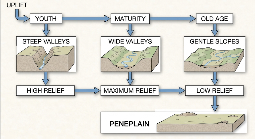
Davis's concept was directly asked in the 2025 Major and Minor question papers.
6. Explain the three stages of Davis's geographical cycle of erosion.
Answer: Davis divided the geographical cycle into three major stages: youth, maturity and old age.
1. Youth
The cycle begins after the land is uplifted. Rivers have steep gradients and flow rapidly. Vertical erosion is dominant, resulting in deep and narrow valleys, waterfalls and rapids. The landscape has considerable relief.
2. Maturity
With continued erosion, the valleys become deeper and wider. Lateral erosion becomes increasingly important. The drainage network becomes well developed. Slopes are modified and the landscape reaches its greatest development of relief. Rivers begin to develop wider valleys and meanders in suitable areas.
3. Old Age
In the old-age stage, prolonged erosion reduces the overall relief. Slopes become gentle and valleys become broad. Rivers have lower gradients and deposition becomes relatively more important. The landscape approaches a low-relief surface known as a peneplain.
The sequence may be represented as:
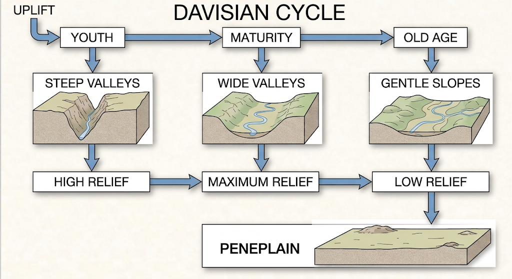
Davis considered this cycle a useful model for explaining landscape evolution through time. However, actual landscapes may not always follow the ideal sequence exactly because tectonic activity, climate and different rock structures can influence development.
7. Discuss the role of structure, process and time in landform development. [2025]
Answer: Landform development can be understood through the combined influence of structure, process and time. This relationship is especially important in the Davisian approach to geomorphology.
Structure refers to the geological characteristics of an area. Rock type, hardness, faults, folds, joints and the arrangement of rock layers influence the way landscapes develop. Resistant rocks generally withstand erosion better than weaker rocks.
Process refers to the natural forces and mechanisms that modify the Earth's surface. Weathering, erosion, transportation, deposition, mass movement and tectonic processes are important geomorphological processes. Rivers, glaciers, wind and waves are also major agents of landform development.
Time determines how long these processes operate. A landscape may undergo considerable change when geomorphic processes continue for thousands or millions of years. Therefore, the same process can produce different results at different stages of landscape evolution.
Davis expressed this relationship through his famous idea that landforms are a function of structure, process and time. In his geographical cycle, an uplifted landscape is gradually modified by erosion through youth, maturity and old age.
Thus, no landform can be properly understood by studying only one factor. Its present form is the result of the interaction between geological structure, geomorphic processes and the time available for those processes to work. The 2025 Major paper included this Davisian concept in its one-mark section.
8. Discuss the significance of geomorphological studies.
Answer: Geomorphological studies are important for understanding the physical structure and evolution of the Earth's surface. Geomorphology explains how mountains, plateaus, plains, valleys, coastal features and other landforms originate and change.
One major significance is environmental understanding. Knowledge of geomorphic processes helps us understand soil erosion, landslides, floods, riverbank erosion and other environmental problems.
Geomorphology is also important for land-use planning. Before constructing roads, bridges, dams, buildings and settlements, it is necessary to understand the stability and characteristics of the land.
It also helps in disaster management. Areas vulnerable to landslides, floods, coastal erosion and other hazards can be identified through geomorphological studies.
Geomorphology has an important role in resource management. Rivers, groundwater systems, soils and other natural resources are influenced by landforms and geomorphic processes.
It also contributes to the understanding of landscape evolution. By studying present processes, past environmental conditions and changes in landforms can be reconstructed.
Finally, geomorphology has strong interdisciplinary connections with geology, climatology, hydrology, soil science, ecology and environmental studies.
Therefore, geomorphology is not merely the study of landforms; it is a practical science that helps us understand, manage and conserve the Earth's physical environment.
9. Discuss the place of geomorphology among the different branches of physical geography. [2025]
Answer: Geomorphology occupies an important position among the branches of physical geography because it deals with the Earth's surface and the processes responsible for its development. Physical geography studies the natural features and processes of the Earth, and geomorphology forms one of its major branches.
Geomorphology has a close relationship with climatology, because climate influences weathering, erosion and other surface processes. For example, humid and arid climates produce different types of landscapes.
It is related to hydrology because rivers and groundwater are important agents of erosion, transportation and deposition. River valleys, floodplains and deltas cannot be understood without studying water processes.
Geomorphology is also closely connected with biogeography, as vegetation influences soil formation, slope stability and erosion. In turn, landforms influence the distribution of plants and animals.
Its relationship with soil geography is also important because soil development is influenced by relief, parent material, drainage and geomorphic processes.
Geomorphology has a particularly close connection with geology, since rock type, geological structure and tectonic movements strongly influence landform development.
Thus, geomorphology acts as an important link among several branches of physical geography. It helps develop an integrated understanding of the Earth's physical environment. This topic was directly included in the 2025 Minor paper.
10. Explain the evolution of geomorphological thought with reference to catastrophism, uniformitarianism and the Davisian concept.
Answer: The development of geomorphological thought involved several important ideas about how the Earth's surface changes. Three particularly important concepts are catastrophism, uniformitarianism and the Davisian geographical cycle.
Catastrophism was an early approach that explained major changes in Earth's surface mainly through sudden and extraordinary events. Large floods, earthquakes and volcanic eruptions were considered important causes of major landscape changes.
Later, uniformitarianism became influential. Associated with James Hutton and later popularised by Charles Lyell, it argued that the same basic natural laws and processes operating today also operated in the past. This encouraged scientists to study present-day processes to understand landscape history.
In the late nineteenth and early twentieth centuries, W. M. Davis developed his geographical cycle of erosion. He proposed that landforms evolve through time as a result of the interaction of structure, process and time. An uplifted landscape passes through youth, maturity and old age and eventually approaches a peneplain.
These ideas helped geomorphology develop from descriptive studies into a more systematic science of landscape evolution. Modern geomorphology recognises the importance of both gradual processes and sudden events, while also considering tectonics, climate, rock structure and changing environmental conditions.