১ নম্বৰীয়া প্ৰশ্নোত্তৰ :
১. বান্ধ-প্ৰেৰিত ভূমিকম্পীয়তা (Reservoir Induced Seismicity - RIS) কি?
উত্তৰ: বৃহৎ নদীবান্ধ বা জলাশয়ত পানী জমা কৰাৰ ফলত শিলাস্তৰৰ ওপৰত বৃদ্ধি পোৱা চাপৰ কাৰণে সৃষ্টি হোৱা ভূ-কম্পনক RIS বোলে।
২. মথাউৰি ছিঙি হোৱা বানপানীৰ ভৌগোলিক নাম কি?
উত্তৰ: ব্ৰীচ ফ্ল্যাড (Breach Flood) বা আকস্মিক প্লাৱন।
৩. 'মিচিং' জনগোষ্ঠীয়ে বানপানীৰ পৰা ৰক্ষা পাবলৈ সাজি উলিওৱা চাংঘৰক কি বোলা হয়?
উত্তৰ: 'চাংঘৰ' বা স্থানীয় ভাষাত 'কাৰেং ঘৰ' (Olung/Kareng)।
৪. ভূমিস্খলন বৃদ্ধি পোৱাৰ এটি প্ৰধান মানৱসৃষ্ট কাৰণ কি?
উত্তৰ: পাহাৰীয়া ঢাল কাটি অবৈজ্ঞানিকভাৱে পথ আৰু গৃহ নিৰ্মাণ কৰা তথা বনাঞ্চল ধ্বংস।
৫. দুৰ্যোগৰ প্ৰেক্ষাপটত 'অসুৰক্ষিততা' (Vulnerability) কি?
উত্তৰ: কোনো এক দুৰ্যোগৰ ক্ষতিকাৰক প্ৰভাৱ প্ৰতিৰোধ বা সহ্য কৰাত অক্ষম হোৱা ভৌগোলিক, সামাজিক বা অৰ্থনৈতিক অৱস্থা।
৬. ব্ৰহ্মপুত্ৰ উপত্যকাত বানপানী নিয়ন্ত্ৰণৰ বাবে ব্যৱহৃত প্ৰধান গাঁথনিগত (Structural) উপায়টো কি?
উত্তৰ: নদীৰ পাৰত মথাউৰি (Embankments) নিৰ্মাণ।
৭. 'জলবায়ু শৰণাৰ্থী' (Climate Refugees) বুলিলে কাক বুজায়?
উত্তৰ: বানপানী, গৰাখহনীয়া বা জলবায়ুজনিত দুৰ্যোগৰ বাবে নিজৰ বাসস্থান এৰি অন্য ঠাইলৈ স্থানান্তৰিত হ'বলৈ বাধ্য হোৱা লোকক।
৮. ভূমিস্বত্ব আৰু সামাজিক স্থানৰ ওপৰত ভিত্তি কৰি দুৰ্যোগৰ প্ৰভাৱ ভিন্ন হোৱা কাৰকটো কি?
উত্তৰ: আৰ্থ-সামাজিক শ্ৰেণী (Socio-economic Class)।
৯. ব্ৰহ্মপুত্ৰ উপত্যকাৰ চৰ অঞ্চলৰ বাসিন্দাসকলে বানপানীৰ পৰা শস্য ৰক্ষা কৰিবলৈ কি ব্যৱস্থা লয়?
উত্তৰ: বানপানীৰ পূৰ্বেই শস্য চপোৱা আৰু দ-মাটিত বান-সহনশীল 'বাও ধান'ৰ খেতি কৰে।
১০. দুৰ্যোগৰ ফলত পুষ্টিহীনতা আৰু স্বাস্থ্যজনিত সমস্যাত সবাতোকৈ বেছি ভোগা দুটা বয়সৰ গোট কি কি?
উত্তৰ: শিশু আৰু বৃদ্ধসকল।
১১. ভূমি ব্যৱহাৰৰ পৰিৱৰ্তনে নগৰীয়া বানপানী (Urban Flood) কেনেদৰে বৃদ্ধি কৰে?
উত্তৰ: মাটি পকীকৰণ কৰাৰ ফলত পানী ভূগৰ্ভলৈ শোষিত নহৈ উপৰিভাগৰ প্ৰবাহ (Surface Runoff) অতিমাত্ৰা বৃদ্ধি কৰে।
১২. থলুৱা জ্ঞান (Indigenous Knowledge) কি?
উত্তৰ: কোনো এটা স্থানীয় সম্প্ৰদায়ে যুগ যুগ ধৰি পৰিৱেশৰ লগত সহাৱস্থান কৰি আহৰণ কৰা পৰম্পৰাগত অভিজ্ঞতা আৰু কৌশল।
১৩. বিশেষভাৱে সক্ষম ব্যক্তিসকল (PwD) দুৰ্যোগৰ সময়ত কিয় অধিক অসুৰক্ষিত?
উত্তৰ: স্থানান্তৰণৰ সমস্যা (Mobility limitation) আৰু বিশেষ সতৰ্কবাৰ্তা বা সুচল আন্তঃগাঁথনিৰ অভাৱৰ বাবে।
১৪. ব্ৰহ্মপুত্ৰৰ বানপানীৰ সময়ত জনসাধাৰণে যোগাযোগৰ বাবে ব্যৱহাৰ কৰা পৰম্পৰাগত বাহনখন কি?
উত্তৰ: কলগছৰ ভুৰ (Banana Raft) আৰু কাঠৰ নাও।
১৫. পাহাৰীয়া অঞ্চলত সেউজ আৱৰণ ধ্বংসৰ ফলত নদীৰ বুকুত হোৱা সমস্যাটো কি?
উত্তৰ: নদীৰ বুকুত পলি জমা হোৱা বা চিলটেচন (Siltation)।
২ নম্বৰীয়া প্ৰশ্নোত্তৰ :
১. নদীৰ দুয়োপাৰে মথাউৰি নিৰ্মাণে বান পৰিস্থিতি কেনেদৰে অধিক জটিল কৰি তোলে?
উত্তৰ: মথাউৰিয়ে নদীৰ স্বাভাৱিক প্লাৱনভূমিত পানী আৰু পলি বিস্তাৰিত হোৱাত বাধা দিয়ে। ফলত নদীৰ বুকুত পলি জমা হৈ তলিভাগ ওখ হৈ পৰে। ইয়াৰ ফলত নদীৰ জলধাৰণ ক্ষমতা হ্ৰাস পায় আৰু কোনোবা অংশত মথাউৰি ভাঙিলে কাষৰীয়া অঞ্চলত প্ৰচণ্ড ধ্বংসলীলাৰ সৃষ্টি কৰে।
২. বৃহৎ নদীবান্ধে ভাটি অঞ্চলত সৃষ্টি কৰা দুটা প্ৰধান দুৰ্যোগ উল্লেখ কৰা।
উত্তৰ:
বাৰিষা কালত হঠাৎ নদীৰ বান্ধৰ পৰা অতিৰিক্ত পানী এৰি দিলে নামনি অঞ্চলত আকস্মিক বানপানী (Flash flood) সৃষ্টি হয়।
নদীৰ স্বাভাৱিক গতি আৰু পলসৰ চলাচল বন্ধ হৈ ভাটি অঞ্চলৰ কৃষিভূমিৰ উৰ্বৰতা হ্ৰাস পায় আৰু নদীৰ পাৰ খহি পৰে।
৩. নগৰীকৰণ আৰু ভূমি ব্যৱহাৰৰ পৰিৱৰ্তনে কেনেদৰে গুৱাহাটীত কৃত্রিম বানৰ সৃষ্টি কৰিছে?
উত্তৰ: পাহাৰ কাটি আৰু জলাশয়-আৰ্দ্ৰভূমি (যেনে— দীপৰ বিল) পুতি অনিয়ন্ত্ৰিত নিৰ্মাণকাৰ্য কৰাৰ ফলত বৰষুণৰ পানী প্ৰাকৃতিকভাৱে ওলাই যাব নোৱাৰে। ভূমিৰ শোষণ ক্ষমতা হ্ৰাস পোৱাৰ ফলত কম সময়ৰ বৰষুণতে কৃত্রিম বানে গুৱাহাটী মহানগৰী প্লাৱিত কৰে।
৪. দুৰ্যোগৰ সময়ত মহিলাসকল পুৰুষতকৈ কিদৰে অধিক ক্ষতিগ্ৰস্ত হয়?
উত্তৰ: সামাজিক আৰু সাংস্কৃতিক বাধ্যবাধকতাৰ বাবে মহিলাসকলৰ স্থানান্তৰণ সীমিত হয়। ইয়াৰ উপৰিও আশ্ৰয় শিবিৰত শৌচাগাৰৰ অভাৱ, অনাময় আৰু প্ৰজনন স্বাস্থ্যজনিত সমস্যা, গোপনীয়তাৰ অভাৱ আৰু খাদ্য বিতৰণত লিংগভিত্তিক বৈষম্যৰ বাবে মহিলাসকল অধিক অসুৰক্ষিত হৈ পৰে।
৫. বিশেষভাৱে সক্ষম ব্যক্তিসকলৰ বাবে দুৰ্যোগ ব্যৱস্থাপনা কেনেদৰে প্ৰভাৱিত হয়?
উত্তৰ: দুৰ্যোগৰ পূৰ্বানুমানৰ সতৰ্কবাৰ্তা (যেনে— দৃষ্টিহীন বা শ্ৰৱণহীনসকলৰ উপযোগী সংকেত) নোপোৱা আৰু জৰুৰী অৱস্থাত খৰখেদাকৈ নিৰাপদ স্থানলৈ যোৱাৰ বাধাৰ বাবে তেওঁলোকে প্ৰাণ হেৰুৱাব লগা হয়। আশ্ৰয় শিবিৰসমূহত ৰেম্প বা বিশেষ শৌচাগাৰৰ অভাৱে তেওঁলোকৰ কষ্ট বৃদ্ধি কৰে।
৬. বয়োজ্যোষ্ঠ (বৃদ্ধ) লোকসকল বানপানী বা দুৰ্যোগৰ সময়ত কি কি সমস্যাৰ মুখামুখি হয়?
উত্তৰ: বৃদ্ধসকলৰ শাৰীৰিক সক্ষমতা আৰু ৰোগ প্ৰতিৰোধ ক্ষমতা কম। বানপানীৰ সময়ত নিয়মীয়া ঔষধৰ অভাৱ, ঠাণ্ডা আৰু দূষিত পানীৰ পৰা হোৱা সংক্ৰমণ, আশ্ৰয় শিবিৰলৈ যাবলৈ আনৰ ওপৰত নিৰ্ভৰশীলতা আৰু মানসিক আঘাতেই তেওঁলোকৰ প্ৰধান সমস্যা।
৭. ভৌগোলিক অৱস্থানে কেনেদৰে মানুহৰ দুৰ্যোগৰ মাত্ৰা নিৰ্ধাৰণ কৰে?
উত্তৰ: নদীৰ চৰ-চাপৰি, বানপ্ৰৱণ অঞ্চল বা থিয় পাহাৰীয়া ঢালত বসবাস কৰা লোকসকল দুৰ্যোগৰ প্ৰত্যক্ষ বলি হয়। ইয়াৰ বিপৰীতে ওখ আৰু সুৰক্ষিত স্থানত থকা লোকসকল ভৌগোলিকভাৱেই প্ৰাকৃতিক দুৰ্যোগৰ পৰা আপেক্ষিকভাৱে সুৰক্ষিত থাকে।
৮. ব্ৰহ্মপুত্ৰৰ বান ব্যৱস্থাপনাত 'চাংঘৰ'ৰ প্ৰাসংগিকতা কি?
উত্তৰ: মিচিং আদি জনজাতীয় সম্প্ৰদায়ৰ চাংঘৰসমূহ কাঠ বা বাঁহেৰে ওখ খুঁটাৰ ওপৰত নিৰ্মাণ কৰা হয়। ইয়াৰ ফলত বানপানীৰ স্তৰ বৃদ্ধি পালেও মূল বাসগৃহলৈ পানী সোমাব নোৱাৰে। এই পৰম্পৰাগত স্থাপত্যই লোকসকলক পানীত বুৰ নোযোৱাকৈ বসবাস আৰু শস্য মজুত ৰখাত সহায় কৰে।
৯. ব্ৰহ্মপুত্ৰ উপত্যকাত বানপানী মোকাবিলা কৰাত পৰম্পৰাগত নাও আৰু ভুৰৰ ভূমিকা কি?
উত্তৰ: জৰুৰীকালীন অৱস্থাত চৰকাৰী সাহায্য পোৱাৰ পূৰ্বেই স্থানীয়ভাৱে কলগছ আৰু বাঁহেৰে নিৰ্মিত ভুৰ আৰু সৰু নাৱেৰে মানুহ, পশুধন আৰু লাগতিয়াল বস্তু নিৰাপদ ওখ স্থানলৈ স্থানান্তৰ কৰাত এইবোৰ এক অপৰিহাৰ্য থলুৱা বাহন।
১০. বনাঞ্চল ধ্বংসই জলচক্ৰ আৰু দুৰ্যোগ বৃদ্ধিত কেনে প্ৰভাৱ পেলায়?
উত্তৰ: বনাঞ্চল ধ্বংসৰ ফলত মাটিৰ পানী ধৰি ৰখা ক্ষমতা কমে। ফলত বৰষুণৰ পানী ক্ষিপ্ৰভাৱে পাহাৰৰ পৰা নামি নদীৰ বুকুলৈ আহে, যিয়ে নদীৰ পলস বৃদ্ধি কৰি ভৈয়ামত বানপানী আৰু পাহাৰত ভূমিস্খলন তীব্ৰতৰ কৰি তোলে।
১১. আদিবাসী আৰু জনজাতীয় সম্প্ৰদায়ৰ ওপৰত দুৰ্যোগৰ প্ৰভাৱ কিয় সুকীয়া?
উত্তৰ: জনজাতীয় লোকসকল প্ৰাকৃতিক সম্পদ আৰু অৰণ্যৰ ওপৰত গভীৰভাৱে নিৰ্ভৰশীল। দুৰ্যোগৰ ফলত বনজ সম্পদ ধ্বংস হ'লে বা স্থানান্তৰিত হ'বলগীয়া হ'লে তেওঁলোকৰ পৰম্পৰাগত জীৱিকা, খাদ্য সুৰক্ষা আৰু সাংস্কৃতিক স্বকীয়তা সম্পূৰ্ণৰূপে বিপন্ন হয়।
১২. ব্ৰহ্মপুত্ৰৰ বানপ্ৰৱণ অঞ্চলত থলুৱা শস্য বৈচিত্ৰ্যৰ ভূমিকা কি?
উত্তৰ: স্থানীয় কৃষকে 'বাও ধান'ৰ দৰে গভীৰ পানীতো বৃদ্ধি পাব পৰা ধান আৰু কম সময়ত পকা শস্যৰ খেতি কৰে। বানপানীৰ সময়ৰ লগত খাপ খুৱাই কৰা এই কৃষি প্ৰণালীয়ে বানৰ পিছতো খাদ্য নাটনি নোহোৱাকৈ ৰখাত সহায় কৰে।
১৩. দুৰ্যোগ ব্যৱস্থাপনাত স্থানীয় প্ৰাকৃতিক লক্ষণ চিনাক্তকৰণ কিদৰে সহায়ক?
উত্তৰ: থলুৱা লোকসকলে পৰুৱাৰ গতিবিধি, আকাশৰ ডাৱৰৰ ৰং, চৰাইৰ মাত আৰু নদীৰ পানীৰ ৰং বা সোঁত চাই আগতীয়াকৈ বান বা ধুমুহাৰ আগমন অনুমান কৰি প্ৰস্তুতি চলাব পাৰে, যিটো স্থানীয় প্ৰাক-সতৰ্কবাৰ্তাৰ কাম কৰে।
১৪. 'উন্নয়ন-জনিত স্থানচ্যুতি' (Development-induced Displacement) বুলিলে কি বুজা?
উত্তৰ: বৃহৎ নদীবান্ধ নিৰ্মাণ, ৰাষ্ট্ৰীয় ঘাইপথ সম্প্ৰসাৰণ বা উদ্যোগ স্থাপনৰ দৰে উন্নয়নমূলক প্ৰকল্পৰ বাবে স্থানীয় জনসাধাৰণক নিজৰ ভূমি আৰু বাসগৃহৰ পৰা বলপূৰ্বক বা পৰিস্থিতিগতভাৱে উচ্ছেদ কৰা প্ৰক্ৰিয়াক বুজায়।
১৫. দুৰ্যোগৰ লগত 'দৰিদ্ৰতা'ৰ আন্তঃসম্পৰ্ক কি?
উত্তৰ: দৰিদ্ৰ লোকসকল সাধাৰণতে নিৰাপত্তাহীন ঠাইত বসবাস কৰে আৰু তেওঁলোকৰ পকী গৃহ বা বিকল্প সম্পদ নাথাকে। দুৰ্যোগে তেওঁলোকৰ মজুত সম্পদ ধ্বংস কৰি পুনৰ এক অন্তহীন দাৰিদ্ৰ্যৰ চক্ৰবেহুত (Vicious circle of poverty) আৱদ্ধ কৰে।
৫ নম্বৰীয়া প্ৰশ্নোত্তৰ :
১. উন্নয়নমূলক প্ৰকল্পসমূহে (নদীবান্ধ আৰু মথাউৰি) কেনেদৰে দুৰ্যোগৰ উৎস (Disaster Genesis) হিচাপে কাম কৰে? ব্ৰহ্মপুত্ৰ উপত্যকাৰ উদাহৰণসহ আলোচনা কৰা।
উত্তৰ: উন্নয়ন আৰু দুৰ্যোগৰ মাজত এক ওতঃপ্ৰোত সম্পৰ্ক আছে। বহুক্ষেত্ৰত অদূৰদৰ্শী উন্নয়নমূলক কাম-কাজেই পৰৱৰ্তী সময়ত মানৱসৃষ্ট দুৰ্যোগৰ মূল কাৰণ হৈ পৰে।
নদীবান্ধ (Dams): উত্তৰ-পূৰ্বাঞ্চলত জলবিদ্যুৎ প্ৰকল্পৰ বাবে নিৰ্মিত নদীবান্ধসমূহে ভাটি অঞ্চলৰ পৰিৱেশৰ বিস্তৰ ক্ষতি কৰে। বাৰিষা কালত অৰুণাচলৰ পাহাৰত হোৱা অতিবৃষ্টিৰ সময়ত যেতিয়া বান্ধৰ পানী হঠাৎ এৰি দিয়া হয় (যেনে— ৰঙানদী প্ৰকল্পৰ পানী), তেতিয়া লখিমপুৰ আৰু ধেমাজি জিলাত ভয়ংকৰ আকস্মিক বানপানী (Flash flood) আৰু পলস পৰি খেতি পথাৰ ধ্বংস হয়। তদুপৰি ভূ-কম্পনপ্ৰৱণ অঞ্চল হোৱাৰ বাবে বৃহৎ বান্ধ ভাঙি যোৱাৰ সম্ভাৱনাই এক স্থায়ী দুৰ্যোগৰ আশংকা বহন কৰে।
মথাউৰি (Embankments): ১৯৫০ চনৰ ভূমিকম্পৰ পিছত ব্ৰহ্মপুত্ৰ আৰু ইয়াৰ উপনৈসমূহত হাজাৰ হাজাৰ কিলোমিটাৰ মথাউৰি সজা হৈছিল। ই নদীখনক এটা সংকীৰ্ণ সীমাত বান্ধি ৰাখে। ফলত পলস তলীত জমা হৈ নদীৰ তলি ওখ হৈ পৰে। ফলস্বৰূপে মথাউৰি ফুটিলে ওলাই অহা পানীৰ প্ৰচণ্ড বেগে পলকতে শ-শ গাঁও নিঃচিহ্ন কৰি পেলায় আৰু পানী ওলাই যাব নোৱাৰি দীৰ্ঘদিনীয়া জলমগ্নতাৰ সৃষ্টি কৰে।
এনেদৰে সাময়িক সুৰক্ষাৰ নামত কৰা গাঁথনিগত হস্তক্ষেপে দীৰ্ঘম্যাদীভাৱে দুৰ্যোগৰ সৃষ্টি আৰু তীব্ৰতা বৃদ্ধি কৰি আহিছে।
২. ভূমি ব্যৱহাৰৰ পৰিৱৰ্তনে নগৰীয়া আৰু পাহাৰীয়া অঞ্চলত কেনেদৰে পৰিৱেশীয় দুৰ্যোগ মাতি আনিছে?
উত্তৰ: দ্ৰুত জনসংখ্যা বৃদ্ধি আৰু অৰ্থনৈতিক কাৰ্যকলাপৰ বাবে ভূমিৰ স্বাভাৱিক ব্যৱহাৰৰ আমূল পৰিৱৰ্তন ঘটিছে, যিয়ে প্ৰাকৃতিক ভাৰসাম্য বিনষ্ট কৰি দুৰ্যোগ মাতি আনিছে:
পাহাৰীয়া অঞ্চলত ভূমিস্খলন: পাহাৰৰ ঢাল কাটি অবৈজ্ঞানিকভাৱে ঘৰ-দুৱাৰ, ৰিজৰ্ট আৰু ৰাষ্ট্ৰীয় ঘাইপথ সম্প্ৰসাৰণ কৰাৰ ফলত শিলাস্তৰ আলগা হৈ পৰে। গছ-গছনি কটাৰ বাবে মাটিৰ ধাৰণ ক্ষমতা কমে আৰু বাৰিষা প্ৰচণ্ড ভূমিস্খলন সংঘটিত হয় (যেনে— গুৱাহাটীৰ পাহাৰসমূহ আৰু ডিমা হাছাওৰ পথসমূহ)।
আৰ্দ্ৰভূমি আৰু জলাশয় ধ্বংস: নগৰীকৰণৰ বাবে স্বাভাৱিক পানী জমা হোৱা বিল, জলাশয় আৰু পিটনি পুতি পেলোৱা হৈছে। ইয়াৰ ফলত প্ৰাকৃতিক স্পঞ্জ (Sponge) হিচাপে কাম কৰা ব্যৱস্থাটো ধ্বংস হৈছে।
মাটি পকীকৰণ (Impervious Surfaces): পথ, ফুটপাথ আৰু গৃহ নিৰ্মাণৰ ফলত বৰষুণৰ পানী মাটিৰ তললৈ শোষিত হ'ব নোৱাৰে। পানীৰ উপৰিভাগৰ প্ৰবাহ অতিমাত্ৰা বৃদ্ধি পাই নলা-নৰ্দমাৰে বৈ যাব নোৱাৰি নগৰীয়া কৃত্রিম বানপানী (Urban Flood) সৃষ্টি কৰে।
ভূমি ব্যৱহাৰৰ পৰিকল্পনাহীন পৰিৱৰ্তনেই আজি চহৰ আৰু পাহাৰীয়া অঞ্চলৰ দুৰ্যোগৰ প্ৰধান কাৰক হৈ পৰিছে।
৩. দুৰ্যোগৰ প্ৰভাৱ বিভিন্ন আৰ্থ-সামাজিক শ্ৰেণী (Class) আৰু ভৌগোলিক অৱস্থানৰ ওপৰত কেনেদৰে ভিন্ন হয়?
উত্তৰ: দুৰ্যোগ সকলোৰে বাবে সমানে ক্ষতিকাৰক নহয়; ই মানুহৰ সামাজিক-অৰ্থনৈতিক শ্ৰেণী আৰু বাসস্থানৰ ভৌগোলিক স্থানৰ ওপৰত নিৰ্ভৰ কৰি ভিন্ন মাত্ৰাত প্ৰভাৱ পেলায়।
ভৌগোলিক অৱস্থানৰ প্ৰভাৱ: ব্ৰহ্মপুত্ৰৰ চৰ-চাপৰি, নদীৰ পাৰ আৰু নিম্ন প্লাৱনভূমিত বাস কৰা লোকসকল প্ৰতিটো বাৰিষাতে পানীৰ কবলত পৰে। আনহাতে ওখ ভূখণ্ডত বাস কৰাসকল তুলনামূলকভাৱে অপ্ৰভাৱিত থাকে। পাহাৰীয়া অঞ্চলত বিপজ্জনক ঢালত বাস কৰা লোকসকল ভূমিস্খলনৰ মুখত পৰে।
আৰ্থ-সামাজিক শ্ৰেণীৰ প্ৰভাৱ:
দৰিদ্ৰ আৰু শ্ৰমিক শ্ৰেণী: এই শ্ৰেণীৰ লোকৰ ঘৰ-দুৱাৰ কেঁচা বাঁহ-খেৰেৰে নিৰ্মিত হোৱাত সহজে ধ্বংস হয়। তেওঁলোকৰ কোনো সঞ্চিত ধন বা বীমা নাথাকে। বানপানীৰ সময়ত দৈনিক মজুৰি হেৰুৱাই তেওঁলোক অনাহাৰে থাকিবলগীয়া হয়।
উচ্চ আৰু মধ্যবিত্ত শ্ৰেণী: তেওঁলোক পকী আৰু সুৰক্ষিত আৱাসত বাস কৰে। দুৰ্যোগৰ পূৰ্বানুমান পাই তেওঁলোকে সহজে খাদ্য মজুত কৰিব পাৰে বা নিৰাপদ ঠাইলৈ আঁতৰি যাব পাৰে। অৰ্থনৈতিক সামৰ্থ্যৰ বাবে তেওঁলোকে দুৰ্যোগৰ ক্ষতি সহজে পূৰণ কৰি ল'ব পাৰে।
গতিকে দেখা যায় যে দুৰ্যোগে সমাজৰ দুৰ্বল শ্ৰেণীটোক আটাইতকৈ বেছি জুৰুলা কৰে।
৪. দুৰ্যোগ ব্যৱস্থাপনাত লিংগভিত্তিক অসুৰক্ষিততা (Gender Vulnerability) সম্পৰ্কে আলোচনা কৰা।
উত্তৰ: দুৰ্যোগৰ সময়ত আৰু তাৰ পৰৱৰ্তী পৰ্যায়ত সমাজৰ মহিলা আৰু কিশোৰীসকল পুৰুষৰ তুলনাত বিশেষভাৱে সংবেদনশীল আৰু অসুৰক্ষিত হৈ পৰে। ইয়াৰ কাৰণসমূহ হ'ল:
স্থানান্তৰণ আৰু সুৰক্ষাৰ অভাৱ: সামাজিক নীতি-নিয়ম আৰু পৰিয়ালৰ দায়িত্বৰ বাবে দুৰ্যোগৰ সময়ত মহিলাসকলে ঘৰ এৰি সহজে ওলাই আহিব নোৱাৰে। আশ্ৰয় শিবিৰসমূহতো তেওঁলোক শাৰীৰিক নিৰ্যাতন আৰু যৌন নিৰ্যাতনৰ আশংকাত ভোগে।
স্বাস্থ্য আৰু অনাময় সমস্যা: আশ্ৰয় শিবিৰ বা বানপীড়িত অঞ্চলত সুকীয়া আৰু সুৰক্ষিত শৌচাগাৰ নথকাৰ বাবে মহিলা আৰু যুৱতীসকল চৰম অস্বস্তিত পৰে। ঋতুস্ৰাৱকালীন স্বাস্থ্যবিধি আৰু গৰ্ভৱতী মহিলাৰ প্ৰসূতি সেৱা বানপানীৰ সময়ত প্ৰায় স্তব্ধ হৈ পৰে।
পানী আৰু খাদ্য সংগ্ৰহৰ বোজা: পৰিয়ালৰ বাবে খোৱাপানী আৰু খৰি সংগ্ৰহৰ দায়িত্ব মহিলাৰ ওপৰত থাকে। বানৰ সময়ত বহু দূৰ পানী ভাঙি খোৱাপানী আনিবলৈ যাওঁতে তেওঁলোকে নানা ৰোগত আক্ৰান্ত হয়।
সিদ্ধান্ত গ্ৰহণত অংশগ্ৰহণৰ অভাৱ: দুৰ্যোগ প্ৰশমন আৰু সাহায্য বিতৰণ প্ৰক্ৰিয়াত পুৰুষৰ প্ৰাধান্য থাকে, যাৰ ফলত মহিলাৰ প্ৰকৃত প্ৰয়োজনীয়তাসমূহ (যেনে— চেনিটেৰী পেড, শিশুৰ খাদ্য আদি) আওকাণ কৰা হয়।
৫. ব্ৰহ্মপুত্ৰ উপত্যকাত জনজাতীয় লোকসকলৰ পৰম্পৰাগত গৃহনিৰ্মাণ আৰু সংহতি কৌশল দুৰ্যোগ ব্যৱস্থাপনাত কিদৰে কাৰ্যকৰী?
উত্তৰ: ব্ৰহ্মপুত্ৰ উপত্যকাৰ থলুৱা জনজাতিসমূহে (বিশেষকৈ মিচিং সম্প্ৰদায়) যুগ যুগ ধৰি বানপানীৰ লগত সহাৱস্থান কৰি জীয়াই থকাৰ এক সুন্দৰ পৰম্পৰাগত জ্ঞান গঢ়ি তুলিছে:
চাংঘৰ নিৰ্মাণ কৌশল: মিচিং জনগোষ্ঠীৰ পৰম্পৰাগত কাঠ-বাঁহৰ চাংঘৰসমূহ মাটিৰ পৰা কেইবা ফুটো ওখকৈ সজা হয়। বানপানী আহিলে তলৰ অংশৰে পানী বৈ যায় কিন্তু মূল বাসগৃহ সুৰক্ষিত থাকে। পানীৰ মাত্ৰা অধিক বৃদ্ধি পালে চাংখন আৰু ওপৰলৈ তুলি লোৱাৰ কৌশল তেওঁলোকে ব্যৱহাৰ কৰে।
শস্য আৰু পশুধন সুৰক্ষা: চাংঘৰৰ ওপৰৰ অংশত (যাক 'ধোঁৱা চাং' বা 'মেৰাম' বোলে) বীজ, খাদ্য-শস্য আৰু লাগতিয়াল সামগ্ৰী আৰ্দ্ৰতা আৰু পানীৰ পৰা মুক্ত কৰি মজুত ৰখা হয়। চাংঘৰৰ কাষতে ওখ মাচা সাজি গাহৰি, কুকুৰা আদি পোহনীয়া জীৱ-জন্তুক ৰখা হয়।
পৰম্পৰাগত খাদ্য সংৰক্ষণ: দুৰ্যোগকালীন খাদ্য নাটনিৰ মোকাবিলা কৰিবলৈ তেওঁলোকে শুকান মাছ, কঁচু শাক, শুকান মাংস আদি আগতীয়াকৈ সংৰক্ষণ কৰি ৰাখে।
জনজাতীয় লোকসকলৰ এই অভিযোজন ব্যৱস্থাটো প্ৰকৃতিৰ লগত যুদ্ধ নকৰি প্ৰকৃতিৰ লগত মিলি থকাৰ (Living with floods) এক উৎকৃষ্ট বৈজ্ঞানিক আৰ্হি।
৬. বানপানী সমস্যা সমাধানত ব্ৰহ্মপুত্ৰ উপত্যকাৰ কৃষকসকলৰ পৰম্পৰাগত জ্ঞান আৰু কৃষি-অভিযোজন ব্যাখ্যা কৰা।
উত্তৰ: ব্ৰহ্মপুত্ৰ উপত্যকাৰ বানপ্ৰৱণ অঞ্চলৰ কৃষকসকলে প্ৰকৃতিৰ নিয়ম বুজি নিজৰ কৃষি ব্যৱস্থাক বানপানীৰ অনুকূলে সজাই লৈছে:
বান-সহনশীল শস্য নিৰ্বাচন: নদী কাষৰীয়া দ-মাটিত কৃষকসকলে পৰম্পৰাগত 'বাও ধান'ৰ (Deepwater rice) খেতি কৰে। বানপানীৰ জলপৃষ্ঠ বৃদ্ধি পোৱাৰ লগে লগে এই ধানৰ গছবোৰো বৃদ্ধি পায় (দৈৰ্ঘ্য ৩-৪ মিটাৰ পৰ্যন্ত হ'ব পাৰে) আৰু পানীৰ ওপৰত ওপঙি থাকে।
শস্যৰ ঋতু পৰিৱৰ্তন: কৃষকসকলে বাৰিষাৰ বানৰ সময়ছোৱা এৰাই চলিবলৈ শীতকালীন 'বৰো ধান' আৰু আগতীয়াকৈ চপোৱা 'আহু ধান'ৰ ওপৰত গুৰুত্ব দিয়ে। বাৰিষাৰ পলসুৱা মাটিত শীতকালত সৰিয়হ, মাহজাতীয় শস্য আৰু শাক-পাচলিৰ প্ৰচুৰ উৎপাদন কৰে।
জৈৱিক ঢাপ আৰু ওখ ভেটি কৃষি: পানীৰ পৰা শস্য ৰক্ষা কৰিবলৈ ওখ ঢাপ বান্ধি বা ওপঙা পাচি-মাচাত শাক-পাচলিৰ খেতি কৰাৰ পৰম্পৰাগত কৌশল চৰ অঞ্চলৰ কৃষকসকলে ব্যৱহাৰ কৰে।
এই থলুৱা কৃষি কৌশলে বানপীড়িত অঞ্চলত খাদ্য সুৰক্ষা অটুট ৰখাত এক গুৰুত্বপূৰ্ণ ভূমিকা পালন কৰি আহিছে।
৭. দুৰ্যোগৰ পূৰ্বানুমান আৰু সংকেত চিনাক্তকৰণত প্ৰকৃতিভিত্তিক থলুৱা জ্ঞানৰ (Indigenous Early Warning) প্ৰয়োগ সম্পৰ্কে লিখা।
উত্তৰ: আধুনিক বৈজ্ঞানিক সঁজুলি বা ৰাডাৰ নথকাৰ সময়তো ব্ৰহ্মপুত্ৰ উপত্যকাৰ স্থানীয় ৰাইজে প্ৰাকৃতিক পৰিৱেশ নিৰীক্ষণ কৰি দুৰ্যোগৰ পূৰ্বানুমান কৰিছিল:
প্ৰাণীকুলৰ আচৰণ নিৰীক্ষণ: বানপানী বা ধুমুহা অহাৰ ঠিক পূৰ্বে পৰুৱাই কণী লৈ ওখ ঠাইলৈ যাত্ৰা কৰা, ভেকুলীৰ অস্বাভাৱিক চিঞৰ-বাখৰ, ডাউক বা অন্যান্য জলচৰ চৰায়ে অস্বাভাৱিক স্থানত বাহ সজা আৰু পোহনীয়া জীৱ-জন্তুৱে অস্থিৰতা প্ৰদৰ্শন কৰা দেখি মানুহে আসন্ন দুৰ্যোগৰ উমান পায়।
বায়ুমণ্ডল আৰু আকাশৰ লক্ষণ: ডাৱৰৰ বিশেষ ৰং, বতাহৰ দিশৰ হঠাৎ পৰিৱৰ্তন আৰু নদীৰ পানীৰ উষ্ণতা বা ঘোলা হোৱাৰ লক্ষণ চাই নদীপৰীয়া ৰাইজে বৰষুণ আৰু নদীৰ পানী বৃদ্ধিৰ সময় নিৰ্ধাৰণ কৰে।
নদীৰ সোঁত আৰু শব্দ: পাহাৰৰ পৰা নামি অহা নদীৰ বুকুত কাঠ-পাত উটি অহা আৰু নদীৰ গভীৰ গৰ্জন শুনি উজনিৰ পাহাৰত ডাৱৰ বিস্ফোৰণ বা বৰষুণ হৈ পানী নামি অহাৰ সংকেত পোৱা যায়।
এই জ্ঞান আধুনিক বৈজ্ঞানিক পূৰ্বানুমান ব্যৱস্থাৰ সৈতে একত্ৰিত কৰিলে সম্প্ৰদায় পৰ্যায়ত ক্ষয়-ক্ষতি বহু পৰিমাণে হ্ৰাস কৰিব পৰা যায়।
৮. বিশেষভাৱে সক্ষম ব্যক্তি (Persons with Disabilities) আৰু শিশুসকলৰ ওপৰত দুৰ্যোগৰ প্ৰভাৱ আৰু তেওঁলোকৰ অন্তৰ্ভুক্তিমূলক দুৰ্যোগ ব্যৱস্থাপনা আলোচনা কৰা।
উত্তৰ: দুৰ্যোগৰ সময়ত বিশেষভাৱে সক্ষম ব্যক্তি আৰু শিশুসকল আটাইতকৈ সহায়হীন অৱস্থাত পৰে।
প্ৰভাৱ:
শিশু: শিশুসকল সহজে পানীত ডুবি যোৱা, খোৱাপানীৰ পৰা ডায়েৰিয়া আদি মহামাৰীত আক্ৰান্ত হোৱা আৰু পুষ্টিহীনতাৰ বলি হয়। বিদ্যালয় বন্ধ হৈ যোৱাৰ ফলত শিক্ষা ব্যাহত হয় আৰু মানসিক ভয়ৰ (Trauma) চিকাৰ হয়।
বিশেষভাৱে সক্ষম ব্যক্তি: শাৰীৰিক প্ৰতিবন্ধকতা থকা ব্যক্তিয়ে নিজেই সাঁতুৰি বা দৌৰি নিৰাপদ ঠাইলৈ যাব নোৱাৰে। হুইলচেয়াৰ বা সহায়ক সঁজুলিবোৰ পানীত নষ্ট হয়।
অন্তৰ্ভুক্তিমূলক দুৰ্যোগ ব্যৱস্থাপনা (Inclusive DRM):
সতৰ্কবাৰ্তা দিওঁতে শব্দ আৰু দৃশ্যমান সংকেত— দুয়োটা মাধ্যম ব্যৱহাৰ কৰিব লাগে।
আশ্ৰয় শিবিৰসমূহত বিশেষভাৱে সক্ষম লোকৰ বাবে সহজে চলাচল কৰিব পৰা ৰেম্প (Ramp) আৰু সুচল শৌচাগাৰ নিৰ্মাণ কৰিব লাগে।
উদ্ধাৰকাৰী দলক এই লোকসকল আৰু শিশুক অগ্ৰাধিকাৰ ভিত্তিত উদ্ধাৰ কৰিবলৈ বিশেষ প্ৰশিক্ষণ দিব লাগে।
৯. "দুৰ্যোগ ব্যৱস্থাপনাত গাঁথনিগত ব্যৱস্থাতকৈ (Structural) অগাঁথনিগত আৰু থলুৱা পদ্ধতি অধিক ফলপ্ৰসূ"— যুক্তি সহকাৰে আলোচনা কৰা।
উত্তৰ: বানপানী আৰু দুৰ্যোগ নিয়ন্ত্ৰণৰ বাবে গ্ৰহণ কৰা গাঁথনিগত ব্যৱস্থা (যেনে— মথাউৰি, নদীবান্ধ) ব্ৰহ্মপুত্ৰ উপত্যকাত সম্পূৰ্ণৰূপে সফল হোৱা নাই। বৰঞ্চ ই নদীৰ পাৰিপাৰ্শ্বিক ভাৰসাম্য বিঘ্নিত কৰিছে। সেয়ে অগাঁথনিগত আৰু থলুৱা ব্যৱস্থাক অধিক ফলপ্ৰসূ বুলি বিবেচনা কৰা হয়:
মথাউৰিৰ সীমাবদ্ধতা: মথাউৰিয়ে পানী সাময়িকভাৱে আৱদ্ধ কৰে যদিও নদীৰ তলি ওখ কৰি ভৱিষ্যতে ভয়াবহ বানপানীৰ সৃষ্টি কৰে। ই ব্যয়বহুল আৰু নিয়মীয়া মেৰামতিৰ অভাৱত বাৰে বাৰে ভাঙে।
অগাঁথনিগত ব্যৱস্থাৰ লাভালাভ:
প্লাৱনভূমি অঞ্চল বিভাজন (Flood Plain Zoning): নদীৰ কাষৰ বিপজ্জনক অংশত নিৰ্মাণকাৰ্য নিষিদ্ধ কৰি কেৱল কৃষি বা উদ্যান শস্যৰ বাবে ব্যৱহাৰ কৰা।
বনাঞ্চল সংৰক্ষণ: নদীৰ অৱবাহিকা আৰু পাহাৰীয়া অঞ্চলত ব্যাপক বৃক্ষৰোপণ কৰি মাটিৰ খহনীয়া ৰোধ কৰা।
থলুৱা জ্ঞানৰ সংযোগ: চাংঘৰ নিৰ্মাণ, বান-সহনশীল শস্যৰ খেতি আৰু ভুৰ-নাও ব্যৱহাৰ কৰিলে নদীৰ স্বাভাৱিক গতিত বাধা নিদিয়াকৈ পানীৰ সৈতে সহাৱস্থান কৰি জীৱন-সম্পত্তি ৰক্ষা কৰা সম্ভৱ হয়।
গতিকে কেৱল পকী নিৰ্মাণৰ সলনি প্ৰকৃতি-আধাৰিত আৰু থলুৱা জ্ঞানৰ অগাঁথনিগত ব্যৱস্থাপনাহে দীৰ্ঘম্যাদী সমাধান।
১০. ব্ৰহ্মপুত্ৰ উপত্যকাৰ জলবায়ু আৰু বানপানী সমস্যাৰ বহনক্ষম সমাধানত থলুৱা জ্ঞান (Indigenous Knowledge) আৰু আধুনিক প্ৰযুক্তিৰ সমন্বয় কিদৰে ঘটাব পাৰি?
উত্তৰ: ব্ৰহ্মপুত্ৰ উপত্যকাৰ দুৰ্যোগ ব্যৱস্থাপনাক বহনক্ষম কৰি তুলিবলৈ থলুৱা জ্ঞান আৰু আধুনিক বিজ্ঞান-প্ৰযুক্তিৰ সংমিশ্ৰণ অপৰিহাৰ্য:
পূৰ্বানুমান ব্যৱস্থাৰ সমন্বয়: উপগ্ৰহ চিত্ৰ, GIS আৰু ৰাডাৰৰ পৰা পোৱা বৈজ্ঞানিক তথ্যসমূহ স্থানীয় ৰাইজৰ প্ৰাকৃতিক লক্ষণ চিনাক্তকৰণৰ অভিজ্ঞতাৰ সৈতে মিলাই সম্প্ৰদায় পৰ্যায়ৰ আগতীয়া সতৰ্কবাৰ্তা ব্যৱস্থা (Community Early Warning System) গঢ়ি তুলিব পাৰি।
বাসগৃহ নিৰ্মাণ প্ৰযুক্তি: পৰম্পৰাগত বাঁহ-কাঠৰ চাংঘৰৰ স্থাপত্য আৰ্হিটোত আধুনিক ইঞ্জিনিয়াৰিঙৰ সহায়ত মজবুত সামগ্ৰী (যেনে— উন্নত চিমেণ্টৰ খুঁটা বা প্লাষ্টিক ড্ৰামৰ ওপঙা ভেটি) ব্যৱহাৰ কৰি কম খৰচী, বান-প্ৰতিৰোধী আধুনিক চাংঘৰ সাজিব পাৰি।
কৃষি গৱেষণাত থলুৱা জাতৰ ব্যৱহাৰ: স্থানীয় 'বাও ধান' বা বান-সহনশীল শস্যসমূহৰ জিনীয় বৈশিষ্ট্য লৈ আধুনিক জৈৱ-প্ৰযুক্তিৰ (Biotechnology) সহায়ত অধিক উৎপাদনশীল আৰু পানীত বহু দিন ডুব গৈ থাকিলেও নষ্ট নোহোৱা নতুন জাত (যেনে— Swarna Sub-1) উদ্ভাৱন কৰা।
অংশগ্ৰহণমূলক পৰিকল্পনা: চৰকাৰী নীতি প্ৰস্তুত কৰোঁতে স্থানীয় গাঁওবাসী, চৰ অঞ্চলৰ লোক আৰু অভিজ্ঞ বৃদ্ধসকলৰ পৰামৰ্শক অন্তৰ্ভুক্ত কৰা।
এনে সমন্বয়ে ব্ৰহ্মপুত্ৰ উপত্যকাত প্ৰকৃতিৰ লগত সামঞ্জস্য ৰাখি এক স্থায়ী আৰু পৰিৱেশ-অনুকূল দুৰ্যোগ প্ৰশমন ব্যৱস্থা গঢ়ি তুলিব।
Very Short Answer Type :
1. What is Reservoir-Induced Seismicity (RIS)?
Answer: RIS refers to earthquakes and micro-tremors triggered by the extra tectonic stress and pore-fluid pressure resulting from the impoundment of water in large dam reservoirs.
2. What is the geographical term for flooding caused by the failure or breach of a river embankment?
Answer: Breach Flood (or catastrophic dyke failure flood).
3. What is the traditional stilted house constructed by the Mising community to mitigate flood hazards called?
Answer: Chang Ghar (locally referred to as Kareng Okum or Olung).
4. State a major anthropogenic factor responsible for accelerated landslides in hilly terrains.
Answer: Unscientific slope excavation for highway construction, unplanned hill cutting, and rampant deforestation.
5. Define 'Vulnerability' in the context of disaster studies.
Answer: Vulnerability is the set of conditions and processes resulting from physical, social, economic, and environmental factors that increase the susceptibility of an individual, community, or asset to the impact of hazards.
6. What is the primary structural flood-control measure adopted across the Brahmaputra Valley?
Answer: The construction of earthen earthen embankments (dykes or levees) along the river and its tributaries.
7. Who are 'Climate Refugees'?
Answer: Individuals and communities forcibly displaced from their original habitats due to severe environmental changes, catastrophic flooding, or persistent riverbank erosion caused by climate variability.
8. Name the socio-economic dimension that dictates varying disaster recovery capacities based on wealth and property ownership.
Answer: Socio-economic Class (economic status/asset base).
9. How do farmers in the riparian char (sandbar) areas traditionally adapt to annual inundation?
Answer: By harvesting pre-monsoon crops early and cultivating deep-water, flood-resilient indigenous paddy varieties such as Bao rice.
10. Which two demographic age groups are most biologically and physically susceptible to disaster-induced health and nutritional crises?
Answer: Infants/children and the elderly.
11. How does land-use and land-cover (LULC) change contribute to urban flash flooding?
Answer: By replacing natural permeable soil and wetlands with impervious concrete surfaces, which sharply reduces water infiltration and drastically accelerates surface runoff.
12. What is Indigenous Knowledge (IK) in disaster management?
Answer: The cumulative, place-based body of practical wisdom, cultural techniques, and environmental observations passed down through generations within local communities to coexist with natural hazards.
13. Why are Persons with Disabilities (PwDs) disproportionately vulnerable during sudden-onset disasters?
Answer: Due to physical mobility limitations, barriers to accessing standard early warning alerts, and a lack of accessible evacuation infrastructure.
14. Name the traditional, readily accessible aquatic transportation method used by flood-affected rural communities in Assam.
Answer: Banana-stem rafts (Bhur) and country boats (Naao).
15. What specific hydrological issue occurs in riverbeds due to extensive deforestation in the upstream catchment areas?
Answer: Heavy siltation (sediment deposition), leading to the aggradation of the riverbed.
2-Mark Questions :
1. How does the construction of continuous river embankments exacerbate flood severity over time?
Answer: Embankments restrict natural channel-floodplain connectivity, preventing sediment from dispersing across the floodplains. Consequently, this silt accumulates on the riverbed itself, raising its elevation (aggradation). This continuous siltation reduces the channel's carrying capacity and results in catastrophic breach flooding during peak monsoon discharges.
2. State two major downstream environmental hazards triggered by large mega-dams.
Answer:
Unregulated, sudden monsoon water releases that trigger devastating downstream flash floods.
Trapping of nutrient-rich sediment behind dam walls, leading to increased downstream riverbed and bank scouring, along with reduced agricultural soil fertility in riparian zones.
3. How has rapid land-use transformation worsened urban flooding in Guwahati?
Answer: The loss of natural retention basins, urban wetland reclamation (such as the degradation of Deepor Beel), and unchecked hill cutting have eliminated the city's natural drainage sinks. As a result, storm runoff rapidly overwhelms artificial drains, causing severe localized urban flooding even after brief showers.
4. In what ways are women disproportionately affected by natural disasters compared to men?
Answer: Socio-cultural norms often restrict women's mobility and access to relief information. In post-disaster relief camps, women face heightened personal safety risks, a lack of privacy, compromised menstrual hygiene, disruption to maternal healthcare, and systematic marginalization during resource distribution.
5. How does disaster management fail to adequately support Persons with Disabilities (PwDs)?
Answer: Mainstream early warning mechanisms often lack multi-sensory designs (such as accessible visual or acoustic alerts), preventing timely evacuation. Furthermore, emergency transit and shelter facilities rarely feature universal access designs (such as ramps or adaptive sanitation), which compounds their vulnerability during crises.
6. Outline the primary health and mobility challenges faced by the elderly during severe floods.
Answer: Senior citizens face impaired physical mobility, making independent evacuation difficult. During prolonged inundations, their susceptibility to water-borne pathogens, respiratory illnesses, hypothermia, disrupted access to chronic medications, and acute psychological stress increases substantially.
7. How does geographic location dictate differential disaster exposure within the Brahmaputra basin?
Answer: Communities settled in low-lying river islands (chars), active floodplains, and unprotected riparian fringes directly face high-velocity currents, inundation, and severe bank erosion. Conversely, populations located in elevated terraces and foothill belts remain physically sheltered from direct fluvial flooding.
8. Explain the structural relevance of the Chang Ghar (stilted house) in traditional flood adaptation.
Answer: The Chang Ghar is built on raised bamboo or timber stilts well above historical high-flood marks. The open space beneath allows floodwaters to flow through freely without exerting destructive hydrostatic pressure on the main dwelling, keeping family members, grain, and valuables secure above water.
9. What role do indigenous banana rafts (Bhur) and country boats play in community disaster response?
Answer: In the crucial initial hours before institutional rescue teams arrive, indigenous banana-stem rafts and small wooden country boats serve as lifeline transport. Constructed entirely from local materials, they enable the rapid rescue of stranded individuals, livestock, and essential household provisions.
10. How does deforestation in upper catchment zones intensify downstream disasters?
Answer: Stripping the upper catchment of its forest cover decreases soil infiltration and interceptive storage. This dramatically increases peak overland runoff, accelerates topsoil erosion, loads river networks with excessive debris and silt, and triggers both flash floods and downstream channel aggradation.
11. Why do tribal and indigenous communities experience disasters differently from urban populations?
Answer: Tribal communities rely directly on local ecosystems, natural forests, and subsistence agriculture for survival. When a disaster strikes, the destruction of these natural resources directly threatens their food security, traditional livelihood systems, and socio-cultural identity.
12. What is the strategic significance of indigenous crop diversity in flood-prone agriculture?
Answer: Traditional farmers cultivate specialized agrarian varieties, such as deep-water Bao paddy, which elongates with rising water levels, alongside quick-maturing Ahu strains. This genetic diversity ensures that agrarian households retain seed reserves and yield harvests despite unpredictable flood rhythms.
13. How do local biological indicators serve as an indigenous early warning system for disasters?
Answer: Coastal and riverine communities observe ecological cues—such as ants moving their eggs to elevated ground, distinct distress calls from aquatic birds, changes in frog chorusing, and shifting water turbidity—to anticipate incoming floods and take early precautions.
14. Define 'Development-induced Displacement' with an environmental example.
Answer: Development-induced displacement occurs when public infrastructure projects (such as mega-dams, highways, or industrial corridors) force communities to leave their ancestral lands, often leading to socio-economic marginalization and landlessness.
15. What is the self-reinforcing link between poverty and disaster vulnerability?
Answer: Impoverished households are forced by financial constraints to settle in high-risk zones, such as unstable hill slopes or active riverbanks, using non-resilient building materials. When disasters destroy their assets, their lack of insurance or savings pushes them deeper into a cycle of poverty.
5-Mark Questions :
1. Critically analyze how development interventions—specifically mega-dams and embankments—act as catalysts for disaster genesis in the Brahmaputra Valley.
Answer: Development interventions often transform natural seasonal phenomena into structural, human-induced disasters when executed without adequate river basin planning.
Mega-Dams and Downstream Fluvial Hazards: The construction of massive run-of-the-river hydroelectric projects in the geologically young, seismically active Eastern Himalayas introduces major downstream vulnerabilities. Unscheduled, sudden releases of stored water during cloudburst events trigger devastating downstream flash floods in districts like Lakhimpur and Dhemaji. These releases also strip topsoil, deposit infertile coarse sand over prime agricultural land, and disrupt local river ecology.
Embankment-Driven Riverbed Aggradation: Following the Assam earthquake of 1950, thousands of kilometers of earthen dykes were constructed as structural flood barriers. By confining the river to a narrow artificial channel, embankments prevent silt from settling naturally across floodplains. Instead, bedloads accumulate within the riverbed itself, raising the channel bed relative to the surrounding countryside. When these earthen walls inevitably breach during high monsoon flows, high-velocity floodwaters pour into adjacent settlements, creating prolonged waterlogging and extensive devastation.
Ultimately, these structural solutions alter natural fluvial geomorphology, turning predictable seasonal inundations into catastrophic disasters.
2. Examine the impact of land-use and land-cover (LULC) changes on triggering urban and slope hazards.
Answer: Unplanned land-use transitions undermine the natural ecological mechanics that stabilize slopes and regulate hydrologic discharge.
Slope Instability and Landslides: In hilly terrains and urban fringes, unscientific slope excavation for infrastructure, resorts, and settlements strips away vegetation. This removes the root systems that anchor the regolith. Infiltration from heavy monsoon rainfall saturates these weakened soil strata, increasing pore-water pressure and triggering catastrophic landslides, as seen across the Guwahati hills and the transport corridors of Dima Hasao.
Degradation of Natural Retention Sinks: Natural wetlands, marshes, and oxbow lakes serve as primary flood retention basins. In urbanizing areas, extensive encroachment, commercial backfilling, and solid waste dumping have degraded these natural sinks (e.g., Deepor Beel), sharply reducing catchment storage capacity.
Urban Imperviousness and Surface Runoff: The conversion of open soils into impermeable asphalt and concrete blocks natural infiltration. Precipitation is converted almost entirely into rapid surface runoff, quickly overwhelming inadequate stormwater drain networks and causing chronic urban flash floods.
Unregulated land-use change destabilizes natural landscapes, turning everyday rainfall events into chronic, high-cost disasters.
3. Discuss the differential impacts of disasters across various socio-economic classes and geographical locations.
Answer: Disaster risk is not distributed equally across society; it is shaped by an intersection of geographic exposure and underlying social stratification.
Geographical Determinants: Populations living on unstable char islands, active floodplains, and precariously steep hill slopes face immediate, frontline exposure to hazards. In contrast, higher terraces and well-planned urban sectors remain physically insulated from the worst impacts of seasonal flooding and slope failures.
Socio-Economic Class Vulnerabilities:
Low-Income and Marginalized Groups: Resource-poor families generally reside in fragile, temporary housing made of thatch, bamboo, or tin. They lack access to insurance, formal credit, and savings. A single flood can wash away their entire physical asset base, leaving them vulnerable to displacement, high-interest informal loans, and long-term poverty.
Affluent and Middle Classes: Wealthier groups possess the financial resilience to live in reinforced, elevated concrete homes. They have the mobility to evacuate early, the resources to stockpile food and medical supplies, and the assets needed to recover quickly through insurance, institutional credit, and diverse revenue streams.
Disaster vulnerability is fundamentally an expression of structural socio-economic inequality, where society's most marginalized groups carry the heaviest burden of environmental hazards.
4. Assess gender-differentiated vulnerabilities during disaster events and post-disaster recovery phases.
Answer: Disasters are not gender-neutral; they intersect with existing socio-cultural structures to create distinct vulnerabilities for women and girls.
Evacuation Constraints and Immediate Risks: Cultural expectations and domestic responsibilities often delay women from evacuating promptly, as they prioritize securing livestock, children, and elderly family members. In many rural settings, lower rates of swimming proficiency and mobility restrictions further increase mortality risks during sudden flash floods.
Sanitation, Privacy, and Health Crises: In crowded temporary relief shelters, women and adolescent girls face a severe lack of safe, partitioned sanitation facilities. This absence compromises menstrual hygiene, creates personal security risks, and increases susceptibility to reproductive tract infections. Disruptions to prenatal and postnatal care also endanger pregnant and lactating mothers.
Post-Disaster Burdens and Economic Insecurity: The responsibility of securing potable water, firewood, and family meals usually falls on women. After a disaster, they must travel longer distances through contaminated floodwaters to fetch provisions. Additionally, relief distribution models often route resources through male heads-of-household, leaving women's specific health, financial, and nutritional needs overlooked.
Disaster planning must incorporate targeted, gender-inclusive frameworks that actively involve women in local disaster committees and decision-making.
5. Explain how indigenous housing architecture and living strategies among tribal groups in the Brahmaputra Valley foster flood resilience.
Answer: Indigenous communities in Assam, most notably the Mising community, have evolved sophisticated, nature-based housing systems that enable them to adapt to recurring floods rather than attempting to control them.
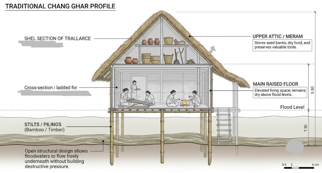
Stilted Engineering (Chang Ghar): The Chang Ghar is constructed on elevated timber or bamboo pilings (Kareng) well above recorded high-flood marks. Its open-frame lower section allows seasonal floodwaters to flow freely beneath the living quarters without exerting destructive pressure on the walls. If flood levels rise higher than expected, the flexible split-bamboo flooring (Tali) can be elevated further within the interior framework.
Integrated Vertical Storage (Meram / Attic): Inside the house, an elevated platform and overhead hearth (Meram) use smoke and dry heat to preserve grain, seeds, and agricultural tools, protecting them from both dampness and flood damage.
Coexistence Strategies: The community prepares for the monsoon by constructing raised platforms for livestock and keeping home-crafted country boats moored to their porches for emergency transport.
This traditional design philosophy embodies a viable model for disaster adaptation: learning to live alongside annual flood rhythms using local resources.
6. Detail the agricultural adaptations and indigenous farming practices deployed by farmers in flood-prone river basins.
Answer: Farmers across the Brahmaputra floodplains have developed resilient agricultural systems tailored to the seasonal rhythms of the river.
Cultivation of Flood-Tolerant Indigenous Rice: Farmers rely on deep-water rice cultivars known as Bao paddy (such as Maguri, Negheri, and Kola Bao). These indigenous varieties can elongate their stems up to several meters as water levels rise, keeping their grain-bearing canopies floating above the flood surface.
Crop-Season Adjustments: To avoid peak monsoon flooding, farmers adjust their planting schedules. They prioritize winter-harvested Boro rice and pre-monsoon Ahu paddy, ensuring crops are safely harvested before the main floods arrive in June and July.
Post-Flood Silt Utilization: In the post-flood winter season, farmers take advantage of the fresh silt (Poli) deposited on the fields. They plant rabi crops—including mustard, pulses, jute, and seasonal vegetables—which thrive on the renewed soil fertility without requiring artificial chemical fertilizers.
Floating Agricultural Beds and Raised Nurseries: In heavily waterlogged and char areas, farmers construct raised, composted seedlings beds and floating nurseries made from aquatic weeds, water hyacinths, and bamboo framing to protect young plants until floodwaters recede.
These indigenous agricultural practices sustain rural food security by adapting cropping systems to natural flood cycles.
7. Examine the role of indigenous environmental observations and ecological markers as early warning systems for natural hazards.
Answer: Long before modern Doppler radar and computerized hydrological models, riverine communities relied on natural bio-indicators and weather patterns to anticipate disasters.
Faunal and Insect Behavior: Changes in animal behavior often signal approaching floods or severe weather:
Large colonies of ants moving their eggs from the ground to higher tree branches indicate rising water tables and heavy rain.
Unusual croaking patterns in amphibians and altered nesting locations chosen by birds (such as swamphens and river terns) signal incoming flash floods.
Agitated, erratic behavior in domesticated cattle and dogs frequently points to impending geological or hydrologic disturbances.
Atmospheric and Riverine Cues: Experienced riverside elders monitor the color, smell, and debris load of the river. Rapidly rising turbidity, floating upland forest debris, and sudden changes in water temperature indicate cloudbursts and flash floods upstream. Similarly, changes in local wind directions (Bordoichila signatures) and unique cloud formations help communities prepare for severe storm surges.
Integrating these community-based indicators with modern, instrument-based early warnings can make local disaster alerts faster, more reliable, and culturally accessible.
8. Analyze the impacts of disasters on children and Persons with Disabilities (PwDs), and suggest strategies for inclusive disaster management.
Answer: Children and Persons with Disabilities (PwDs) are among the most vulnerable groups during environmental emergencies due to physical, physiological, and institutional barriers.
Specific Hazards and Impacts:
Children: Facing heightened risks of drowning, water-borne diseases (such as gastroenteritis and cholera), and acute malnutrition, children are particularly vulnerable during disasters. Disrupted schooling and the loss of safe environments can also cause lasting psychological trauma.
Persons with Disabilities: People with sensory, cognitive, or physical impairments often struggle to access standard emergency alerts or evacuate independently. Assistive technologies (such as wheelchairs and prosthetics) are frequently lost or damaged during sudden evacuations.
Key Strategies for Inclusive Disaster Risk Management (IDRM):
Accessible Early Warnings: Warning systems should use multiple accessible formats, combining audio alarms, visual sirens, and simple text-based SMS messages for deaf and blind individuals.
Universal Design in Shelters: Relief shelters and transition camps must include barrier-free infrastructure, including standard wheelchair ramps, tactile pathways, and accessible, dignified sanitation units.
Priority Rescue and Disaggregated Data: Disaster response agencies should maintain community-level registries of vulnerable individuals to ensure priority evacuation, specialized medical assistance, and targeted nutrition programs during emergencies.
9. "Non-structural and indigenous strategies offer more sustainable long-term solutions for flood management than structural engineering." Justify this statement with reference to the Brahmaputra Valley.
Answer:Decades of reliance on structural flood engineering—primarily earthen embankments and channel modifications—have proven to be costly and environmentally destabilizing across the Brahmaputra Valley. Shifting toward non-structural and indigenous strategies offers a more resilient, ecologically sound alternative.
| Management Approach | Core Interventions | Key Limitations / Long-Term Strengths |
| Structural Engineering | Embankments, dykes, spurs, river training walls, concrete mega-dams. | High capital costs; causes riverbed aggradation; triggers catastrophic breach floods; disrupts natural wetlands. |
| Non-Structural & Indigenous | Floodplain zoning, afforestation, wetland revival, Chang Ghar architecture, Bao rice cultivation. | Cost-effective; preserves floodplain ecological dynamics; works with natural flood rhythms; supports biodiversity. |
Limits of Structural Interventions: Embankments restrict natural channel dynamics, worsen channel siltation, and create a false sense of security that encourages risky development in active floodplains. When these structures breach, the resulting flood damage is often far worse than natural seasonal inundation.
Benefits of Non-Structural Measures:
Floodplain Zoning: Regulating commercial and residential construction in high-risk zones keeps damage to a minimum while preserving open land for seasonal farming.
Ecosystem Restoration: Restoring catchment forests, reviving silted oxbow lakes, and protecting urban wetlands creates natural flood buffers.
Living with Floods: Integrating indigenous practices—such as raised stilted housing (Chang Ghar) and flood-tolerant agriculture—enables communities to adapt to seasonal floods safely and sustainably.
Emphasizing nature-based, non-structural measures allows river systems to maintain their natural hydrology while significantly reducing long-term disaster risk.
10. How can indigenous knowledge be integrated with modern science and technology to build sustainable disaster resilience in the Brahmaputra Valley?
Answer: Building lasting disaster resilience requires combining the precision of modern science with the localized, time-tested wisdom of indigenous communities.
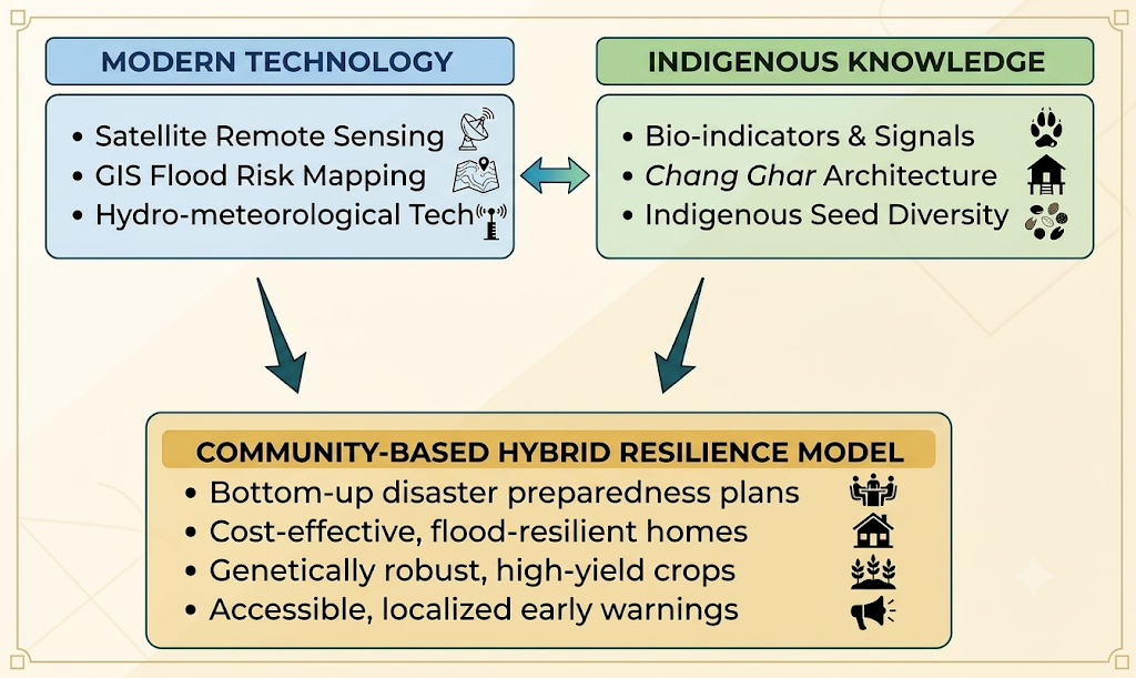
Hybrid Early Warning Networks: Combining real-time satellite remote sensing, Doppler radar, and hydrological data with local ecological indicators allows disaster managers to create Community-Based Early Warning Systems (CBEWS). Delivering alerts through localized mobile networks ensures warnings are clear, timely, and actionable for rural residents.
Architectural Innovation: Engineers can combine traditional Chang Ghar designs with modern materials—such as treated bamboo composites, recycled plastic drums for floating foundations, and reinforced concrete pilings—to build affordable, flood-resilient housing.
Agricultural Biotechnology: Agricultural scientists can use the genetic traits of traditional flood-resilient crops (like Bao paddy) to develop new, high-yield submerged rice strains (e.g., Swarna Sub-1) that can survive weeks underwater without losing productivity.
Participatory Policy Design: Regional disaster planning should actively include local village councils, elders, and riverside communities in formulating hazard mitigation policies, ensuring interventions respect local needs and ecosystems.
Bridging modern technology with indigenous wisdom creates an inclusive, cost-effective, and ecologically balanced framework for long-term disaster management.