অতি চমু প্ৰশ্ন :
১. প্ৰণালীবদ্ধ (Systematic) আৰু আঞ্চলিক (Regional) ভূগোলৰ ভেটি কোনে গঢ়িছিল? [GU 2024]
উত্তৰ: বাৰ্নহাৰ্ড ভাৰেনিয়াছে (Bernhard Varenius) তেওঁৰ ‘Geographia Generalis’ গ্ৰন্থৰ জৰিয়তে প্ৰণালীবদ্ধ আৰু আঞ্চলিক ভূগোলৰ ভেটি গঢ়িছিল।
২. 'আপেক্ষিক স্থান' (Relative Space) বুলিলে কি বুজা? [GU 2024]
উত্তৰ: আপেক্ষিক স্থান হ’ল ভৌগোলিক উপাদানসমূহৰ মাজৰ পাৰস্পৰিক সম্পৰ্ক, দূৰত্ব, সময় বা ব্যয়ৰ ভিত্তিত নিৰ্ধাৰিত হোৱা স্থান।
৩. ভৌগোলিক অৱস্থানৰ এটা প্ৰধান বৈশিষ্ট্য উল্লেখ কৰা। [GU 2024]
উত্তৰ: ভৌগোলিক অৱস্থানক অক্ষাংশ আৰু দ্ৰাঘিমাংশৰ দ্বাৰা এক নিৰ্দিষ্ট আৰু অপৰিৱৰ্তনীয় স্থানাংক (Absolute Location) হিচাপে চিহ্নিত কৰিব পাৰি।
৪. ভূগোলে কি অধ্যয়ন কৰে? [GU 2024]
উত্তৰ: ভূগোলে পৃথিৱীপৃষ্ঠত মানুহ আৰু প্ৰকৃতিৰ মাজৰ পাৰস্পৰিক ক্ৰিয়া-প্ৰতিক্ৰিয়া আৰু স্থানিক পৰিঘটনাৰ বিতৰণ অধ্যয়ন কৰে।
৫. ভূগোলক কিয় 'স্থানিক বিজ্ঞান' (Spatial Science) বুলি কোৱা হয়? এটা যুক্তি দিয়া। [GU 2024]
উত্তৰ: ভূগোলে পৃথিৱীপৃষ্ঠৰ সকলো প্ৰাকৃতিক আৰু মানৱীয় পৰিঘটনাৰ স্থানিক বিতৰণ, বিন্যাস আৰু স্থানিক সংগঠন বিশ্লেষণ কৰে বাবে ইয়াক স্থানিক বিজ্ঞান বোলে।
৬. ভূগোলৰ মুখ্য ভাগ দুটা কি কি? [GU 2024]
উত্তৰ: ভূগোলৰ মুখ্য ভাগ দুটা হ’ল— (ক) প্ৰাকৃতিক ভূগোল (Physical Geography) আৰু (খ) মানৱ ভূগোল (Human Geography)।
৭. 'Geography' শব্দটো সৰ্বপ্ৰথমে কোনে ব্যৱহাৰ কৰিছিল?
উত্তৰ: গ্ৰীক পণ্ডিত ইৰাট’স্থেনিছে (Eratosthenes) খ্ৰীষ্টপূৰ্ব তৃতীয় শতিকাত সৰ্বপ্ৰথমে ‘Geography’ শব্দটো ব্যৱহাৰ কৰিছিল।
৮. ‘পৃথিৱী মানুহৰ বাসস্থান’ (Earth as the home of man)— এই ধাৰণাটো কাৰ?
উত্তৰ: জাৰ্মান ভূগোলবিদ কাৰ্ল ৰিটাৰ (Carl Ritter) আৰু ফ্ৰেডৰিক ৰাটজেলৰ (Friedrich Ratzel)।
৯. ভূগোলৰ কোনটো শাখাই ভূ-প্ৰকৃতি আৰু শিলৰ অধ্যয়ন কৰে?
উত্তৰ: ভূ-আকৃতি বিজ্ঞান (Geomorphology)।
১০. সমাজ বিজ্ঞানৰ লগত প্ৰত্যক্ষভাৱে জড়িত ভূগোলৰ এটা শাখাৰ নাম লিখা।
উত্তৰ: জনসংখ্যা ভূগোল (Population Geography) বা সামাজিক ভূগোল (Social Geography)।
১১. একমাত্ৰিক বা বিন্দুৰ প্ৰতিৰূপ (Point Pattern) বুলিলে কি বুজায়? [GU 2024]
উত্তৰ: মানচিত্ৰত কোনো নিৰ্দিষ্ট ভৌগোলিক উপাদানক (যেনে: বসতি, কুঁৱা, চহৰ) বিন্দু হিচাপে প্ৰদৰ্শন কৰা প্ৰতিৰূপেই হ’ল বিন্দুৰ প্ৰতিৰূপ।
১২. ৰৈখিক প্ৰতিৰূপৰ (Line Pattern) এটা ভৌগোলিক উদাহৰণ দিয়া। [GU 2024]
উত্তৰ: নদী প্ৰণালী অথবা ৰে’লপথ/ৰাষ্ট্ৰীয় ঘাইপথৰ নেটৱৰ্ক।
১৩. আধুনিক ভূগোলৰ পিতৃ বুলি কাক জনা যায়?
উত্তৰ: আলেকজেণ্ডাৰ ভন হামবোল্ট (Alexander von Humboldt) আৰু কাৰ্ল ৰিটাৰক (Carl Ritter)।
১৪. ডেভিদ হাৰ্ভেই ভৌগোলিক ব্যাখ্যাৰ আৰ্হি দাঙি ধৰা বিখ্যাত গ্ৰন্থখনৰ নাম কি? [GU 2024]
উত্তৰ: ‘Explanation in Geography’ (1969)।
১৫. ‘Spatial Organization’ (স্থানিক সংগঠন) শব্দটোৰ অৰ্থ কি? [GU 2024]
উত্তৰ: কোনো এক ভৌগোলিক অঞ্চলত মানৱীয় কাৰ্যকলাপ আৰু প্ৰাকৃতিক উপাদানসমূহ যিদৰে এক সুসংহত ব্যৱস্থা হিচাপে সজোৱা থাকে, তাকে স্থানিক সংগঠন বোলে।
২ নম্বৰীয়া প্ৰশ্নোত্তৰ :
১. ভূগোল সম্পৰ্কে এটা প্ৰামাণিক সংজ্ঞা দিয়া আৰু ভূগোলবিদজনৰ নাম উল্লেখ কৰা। [GU 2024]
উত্তৰ: বিখ্যাত ভূগোলবিদ ৰিচাৰ্ড হাৰ্টছহৰ্ণৰ (Richard Hartshorne) মতে— “ভূগোল হৈছে পৃথিৱীপৃষ্ঠৰ পৰিৱৰ্তনশীল বৈশিষ্ট্যসমূহৰ সঠিক, ক্ৰমবদ্ধ আৰু যুক্তিসংগত বৰ্ণনা আৰু ব্যাখ্যা প্ৰদান কৰা বিজ্ঞান।” অৰ্থাৎ ভূগোলে পৃথিৱীৰ আঞ্চলিক ভিন্নতাৰ অধ্যয়ন কৰে।
২. কেতিয়া এটা স্থানক (Space) এখন ঠাই (Place) বুলি ক’ব পাৰি? [GU 2024]
উত্তৰ: স্থান (Space) হৈছে এক অমূৰ্ত আৰু জ্যামিতিক ধাৰণা। যেতিয়া কোনো এক স্থানত মানুহৰ অনুভৱ, আৱেগ, অৰ্থ, কাৰ্যকলাপ আৰু সাংস্কৃতিক মূল্যবোধ যুক্ত হয়, তেতিয়া সেই নিৰ্দিষ্ট স্থানখণ্ড এক স্বকীয় পৰিচয় লাভ কৰি ‘ঠাই’ (Place) হিচাপে পৰিগণিত হয়।
৩. উদাহৰণসহ ‘অঞ্চল’ৰ (Region) সংজ্ঞা দিয়া। [GU 2024]
উত্তৰ: অঞ্চল হৈছে পৃথিৱীপৃষ্ঠৰ এক সুনিৰ্দিষ্ট ভৌগোলিক এলেকা, যি এক বা একাধিক সমজাতীয় প্ৰাকৃতিক (যেনে: জলবায়ু, ভূ-প্ৰকৃতি) বা আৰ্থ-সামাজিক বৈশিষ্ট্যৰ দ্বাৰা চাৰিওফালৰ এলেকাতকৈ পৃথক। উদাহৰণস্বৰূপে— অসমৰ ব্ৰহ্মপুত্ৰ উপত্যকা এক নিৰ্দিষ্ট ভূ-প্ৰাকৃতিক অঞ্চল।
৪. প্ৰাদেশিক ক্ষেত্ৰ বা ভূ-খণ্ডৰ (Territory) দুটা প্ৰধান বৈশিষ্ট্য উল্লেখ কৰা। [GU 2024]
উত্তৰ: ভূ-খণ্ড বা Territory-ৰ দুটা মুখ্য বৈশিষ্ট্য হ’ল: (ক) ইয়াৰ এক সুস্পষ্ট আৰু আইনীভাৱে স্বীকৃত ভৌগোলিক সীমাৰেখা (Boundary) থাকে। (খ) এই নিৰ্দিষ্ট এলেকাটো কোনো সাৰ্বভৌম চৰকাৰ বা সামাজিক কৰ্তৃপক্ষৰ ৰাজনৈতিক নিয়ন্ত্ৰণ আৰু সাৰ্বভৌমত্বৰ অধীনত থাকে।
৫. তন্ত্ৰ বিশ্লেষণ (System Analysis) কি? [GU 2024]
উত্তৰ: তন্ত্ৰ বিশ্লেষণ হৈছে এক বৈজ্ঞানিক পদ্ধতি য’ত কোনো এক ভৌগোলিক পৰিঘটনাক কিছুমান পাৰস্পৰিক সম্পৰ্কযুক্ত উপাদানৰ এক উমৈহতীয়া গোট বা ব্যৱস্থা হিচাপে অধ্যয়ন কৰা হয়। ইয়াত উপাদানসমূহৰ মাজত শক্তি আৰু পদাৰ্থৰ আদান-প্ৰদান (Input-Output) বিশ্লেষণ কৰা হয়।
৬. ধাৰণাৰ লেখচিত্ৰীয় বিচাৰ পদ্ধতি (Idiographic Approach) কি? [GU 2024]
উত্তৰ: এই পদ্ধতি অনুসৰি সাধাৰণ নিয়ম প্ৰতিষ্ঠা কৰাৰ পৰিৱৰ্তে কোনো এটা নিৰ্দিষ্ট অঞ্চলৰ অনন্য, একক আৰু স্বকীয় ভৌগোলিক বৈশিষ্ট্যসমূহ গভীৰভাৱে বিচাৰ-বিশ্লেষণ কৰা হয়। আঞ্চলিক ভূগোলে মূলতঃ এই ইডিঅ’গ্ৰাফিক দৃষ্টিভংগী অনুসৰণ কৰে।
৭. ভৌগোলিক অৱয়ব বা পৰিঘটনাৰ মাজত থকা স্থানিক সম্বন্ধৰ (Spatial Relationship) দুটা উদাহৰণ দিয়া। [GU 2024]
উত্তৰ: (ক) পাহাৰীয়া ভূ-প্ৰকৃতি আৰু জনবসতিৰ ঘনত্বৰ মাজৰ সম্পৰ্ক (পাহাৰীয়া অঞ্চলত যোগাযোগৰ অসুবিধাৰ বাবে পাতল বসতি)। (খ) কোনো নদীৰ অৱবাহিকা আৰু তাত গঢ়ি উঠা কৃষিভিত্তিক অৰ্থনীতিৰ সম্পৰ্ক।
৮. ‘পৃথিৱী মানুহৰ বাসস্থান’— এই কথাষাৰৰ অৰ্থ কি?
উত্তৰ: ইয়াৰ অৰ্থ হ’ল পৃথিৱীখন কেৱল নিৰ্জীৱ পদাৰ্থ নহয়; ই মানৱজাতিৰ অস্তিত্ব, বিকাশ আৰু বিকাশৰ আধাৰ। পৃথিৱীয়ে মানুহক জীয়াই থাকিবলৈ বায়ু, পানী, খাদ্য আৰু সম্পদৰ যোগান ধৰে আৰু মানুহে নিজৰ প্ৰয়োজন অনুসৰি পৰিৱেশটো ৰূপান্তৰিত কৰে।
৯. প্ৰাকৃতিক বিজ্ঞানৰ লগত ভূগোলৰ দুটা প্ৰত্যক্ষ সম্পৰ্ক উল্লেখ কৰা।
উত্তৰ:
(ক) ভূ-বিজ্ঞান (Geology)-ৰ লগত ভূ-আকৃতি বিজ্ঞানৰ সম্পৰ্ক, যিয়ে ভূ-গঠন বুজাত সহায় কৰে।
(খ) বতৰ বিজ্ঞান (Meteorology)-ৰ লগত জলবায়ু বিজ্ঞানৰ সম্পৰ্ক, যিয়ে বায়ুমণ্ডলৰ গতি-প্ৰকৃতি অধ্যয়ন কৰে।
১০. সমাজ বিজ্ঞানৰ লগত ভূগোলৰ দুটা সম্পৰ্ক উল্লেখ কৰা।
উত্তৰ:
(ক) অৰ্থনীতি বিজ্ঞানৰ লগত অৰ্থনৈতিক ভূগোলৰ সম্পৰ্ক (সম্পদ উৎপাদন আৰু বিতৰণ অধ্যয়ন)।
(খ) ইতিহাসৰ লগত ঐতিহাসিক ভূগোলৰ সম্পৰ্ক (সময়ৰ লগে লগে ভৌগোলিক স্থানৰ বিৱৰ্তন বুজাত সহায় কৰে)।
১১. ভূগোলৰ বহু-বিষয়ক (Multidisciplinary) প্ৰকৃতি বুলিলে কি বুজা?
উত্তৰ: ভূগোলে প্ৰাকৃতিক আৰু সামাজিক উভয় বিজ্ঞানৰ বিভিন্ন বিষয়ৰ (যেনে: ভূতত্ত্ব, উদ্ভিদ বিজ্ঞান, অৰ্থনীতি, সমাজতত্ত্ব) তত্ত্ব আৰু পদ্ধতিসমূহ একত্ৰিত কৰি স্থানিক পৰিপ্ৰেক্ষিতত পৃথিৱীপৃষ্ঠক এক সামগ্ৰিক বিজ্ঞান হিচাপে অধ্যয়ন কৰে বাবেই ই বহু-বিষয়ক।
১২. ভূগোলৰ বিষয়বস্তু সময়ৰ লগে লগে কিদৰে সলনি হৈছে?
উত্তৰ: প্ৰাচীন কালৰ কেৱল পৃথিৱীৰ ঠাইসমূহৰ বিৱৰণ আৰু মানচিত্ৰ অংকনৰ পৰা আৰম্ভ কৰি আধুনিক যুগত ভূগোলে স্থানিক সংগঠন, পৰিৱেশ পৰিচালনা, জি.আই.এছ (GIS) আৰু মানুহ-পৰিৱেশৰ জটিল পাৰস্পৰিক সম্বন্ধ বিশ্লেষণলৈ গতি কৰিছে।
১৩. ভূগোলত আৰোহী পদ্ধতি (Inductive Approach) কি?
উত্তৰ: এই পদ্ধতিত নিৰ্দিষ্ট কিছুমান বাস্তৱিক পৰ্যবেক্ষণ আৰু তথ্যৰ পৰা এক সাধাৰণ সিদ্ধান্ত বা ভৌগোলিক সূত্ৰ প্ৰতিষ্ঠা কৰা হয় (যেনে: কেইবাটাও বজাৰ অধ্যয়ন কৰি কেন্দ্ৰীয় স্থান তত্ত্ব গঢ়ি তোলা)।
১৪. ভূগোলত অৱৰোহী পদ্ধতি (Deductive Approach) কি?
উত্তৰ: এই পদ্ধতিত কোনো পূৰ্ব-প্ৰতিষ্ঠিত সাধাৰণ সূত্ৰ বা তত্ত্বৰ ভিত্তিত কোনো এক নিৰ্দিষ্ট ভৌগোলিক ঘটনা পৰীক্ষা কৰি বিশ্লেষণ কৰা হয়।
১৫. পৰম স্থান (Absolute Space) আৰু আপেক্ষিক স্থানৰ (Relative Space) এটা মূল পাৰ্থক্য লিখা।
উত্তৰ: পৰম স্থান অপৰিৱৰ্তনীয় আৰু ইয়াক জ্যামিতিক বা স্থানাংকৰ দ্বাৰা নিৰ্ধাৰণ কৰা হয়; কিন্তু আপেক্ষিক স্থান সামাজিক, অৰ্থনৈতিক আৰু সময়ৰ দূৰত্বৰ ওপৰত নিৰ্ভৰ কৰি পৰিৱৰ্তিত হয়।
৫ নম্বৰীয়া প্ৰশ্নোত্তৰ :
১. পৃথিৱীখনক কিয় মানুহৰ ঘৰ (Home of Man) বুলি কোৱা হয়? ব্যাখ্যা কৰা। [GU 2024]
উত্তৰ: ভূগোল অধ্যয়নৰ মূল কেন্দ্ৰবিন্দুটোৱেই হ’ল পৃথিৱীপৃষ্ঠক মানুহৰ বাসস্থান হিচাপে বিশ্লেষণ কৰা। তলত উল্লেখ কৰা কাৰণসমূহৰ বাবে পৃথিৱীক মানুহৰ ঘৰ বুলি কোৱা হয়:
জীৱনধাৰণৰ আধাৰ: সৌৰজগতৰ একমাত্ৰ পৃথিৱীতেই জীৱনৰ বাবে অনুকূল বায়ুমণ্ডল (অক্সিজেন), জলমণ্ডল আৰু উপযুক্ত উষ্ণতা আছে, যিয়ে মানুহক জীয়াই থকাৰ পৰিৱেশ দিয়ে।
সম্পদৰ যোগান: মানুহৰ খাদ্য, বস্ত্ৰ, বাসস্থান আৰু আধুনিক সভ্যতা গঢ়াৰ বাবে প্ৰয়োজনীয় সকলো উপাদান— যেনে মাটি, পানী, খনিজ পদাৰ্থ, অৰণ্য আদি পৃথিৱীৰ পৰাই লাভ কৰা হয়।
সাংস্কৃতিক ভূ-দৃশ্য নিৰ্মাণ: মানুহে পৃথিৱীৰ প্ৰাকৃতিক ভূ-প্ৰকৃতিক নিজৰ বাসস্থান, কৃষিভূমি, উদ্যোগ, পথ-ঘাট আৰু নগৰলৈ ৰূপান্তৰিত কৰি ‘সাংস্কৃতিক ভূ-দৃশ্য’ সৃষ্টি কৰিছে।
পাৰস্পৰিক অভিযোজন: পৃথিৱী আৰু মানুহৰ সম্বন্ধ একপক্ষীয় নহয়; মানুহে প্ৰাকৃতিক দুৰ্যোগ আৰু সীমাবদ্ধতাৰ মাজতো পৰিৱেশৰ লগত নিজকে খাপ খুৱাই লৈ সভ্যতাৰ বিকাশ ঘটাইছে।
গতিকে, ভূগোলে কেৱল নিৰ্জীৱ প্ৰকৃতি নহয়, বৰঞ্চ মানৱ সমাজ আৰু প্ৰকৃতিৰ মাজৰ এই আন্তঃক্ৰিয়াশীল বাসস্থলী হিচাপেই পৃথিৱীখন অধ্যয়ন কৰে।
২. ভূগোলৰ বহুধা-বিষয়ক বা আন্তঃবিষয়ক (Multidisciplinary) প্ৰকৃতিৰ ব্যাখ্যা আগবঢ়োৱা। [GU 2024]
উত্তৰ: ভূগোল হৈছে এক সমন্বয়ক বিজ্ঞান (Integrating Science), যিয়ে বিজ্ঞান আৰু কলা শাখাৰ বিভিন্ন বিষয়ৰ মাজত এক সেতুবন্ধন হিচাপে কাম কৰে। ইয়াৰ আন্তঃবিষয়ক প্ৰকৃতি তলত দিয়াধৰণে ব্যাখ্যা কৰিব পাৰি:
প্ৰাকৃতিক বিজ্ঞানৰ সৈতে সম্পৰ্ক: ভূগোলৰ প্ৰাকৃতিক শাখাসমূহ বিভিন্ন মৌলিক বিজ্ঞানৰ সৈতে ওতপ্ৰোতভাৱে জড়িত। উদাহৰণস্বৰূপে—
ভূ-বিজ্ঞান (Geology)-ৰ সহায়ত ভূ-আকৃতি বিজ্ঞান (Geomorphology) গঢ় লৈছে।
বতৰ বিজ্ঞান (Meteorology)-ৰ পৰা জলবায়ু বিজ্ঞান (Climatology)।
উদ্ভিদ আৰু প্ৰাণীবিজ্ঞানৰ পৰা জৈৱ ভূগোল (Biogeography) আৰু মৃত্তিকা বিজ্ঞানৰ পৰা পেড'লজী।
সমাজ বিজ্ঞানৰ সৈতে সম্পৰ্ক: মানৱ ভূগোলৰ শাখাসমূহে মানৱীয় কাৰ্যকলাপ অধ্যয়নৰ বাবে সমাজ বিজ্ঞানৰ সহায় লয়।
অৰ্থনীতিৰ লগত অৰ্থনৈতিক ভূগোল (সম্পদ আৰু ব্যৱসায় বিশ্লেষণ)।
সমাজতত্ত্ব আৰু নৃবিজ্ঞানৰ লগত সামাজিক আৰু সাংস্কৃতিক ভূগোল।
ৰাজনীতি বিজ্ঞানৰ লগত ৰাজনৈতিক ভূগোল আৰু ভূ-ৰাজনীতি (Geopolitics)।
স্থানিক দৃষ্টিভংগী: অন্য বিষয়সমূহে কোনো পৰিঘটনাৰ ‘কি’ আৰু ‘কেতিয়া’ বিশ্লেষণ কৰে, কিন্তু ভূগোলে সেইবোৰক ‘ক’ত’ আৰু ‘কিয় তাত ঘটিছে’— এই স্থানিক পৰিপ্ৰেক্ষিতত সংশ্লেষণ কৰে।
এনেদৰে ভূগোলে বিভিন্ন ক্ষেত্ৰৰ জ্ঞানক একত্ৰিত কৰি এক সুকীয়া স্থানিক মাত্ৰা প্ৰদান কৰে বাবেই ইয়াৰ প্ৰকৃতি বহুমুখী।
৩. প্ৰাকৃতিক আৰু সমাজ বিজ্ঞানৰ সৈতে ভূগোলৰ স্থান আৰু সম্পৰ্ক বিচাৰ কৰা। [GU 2024]
উত্তৰ: বিজ্ঞানৰ জগতখনত ভূগোলৰ স্থান অনন্য। ভূগোলবিদ ইমানুৱেল কান্টৰ মতে, ইতিহাস যেনেকৈ ‘সময়ৰ বিজ্ঞান’, ভূগোল তেনেকৈ ‘স্থানৰ বিজ্ঞান’। ভূগোলে প্ৰাকৃতিক আৰু মানৱীয় পৰিৱেশক সংযোগ কৰে।
| প্ৰাকৃতিক বিজ্ঞানৰ লগত সম্বন্ধ | সমাজ বিজ্ঞানৰ লগত সম্বন্ধ |
| ১. ভূ-বিজ্ঞান আৰু ভূ-আকৃতি বিজ্ঞান: পৃথিৱীৰ অভ্যন্তৰীণ গঠন, শিলা, আৰু প্লেট টেকটনিক্স অধ্যয়নত ভূগোলে ভূ-বিজ্ঞানৰ ওপৰত নিৰ্ভৰ কৰে। | ১. অৰ্থনীতি আৰু অৰ্থনৈতিক ভূগোল: সম্পদৰ উৎপাদন, বিতৰণ, ভোগ আৰু বাণিজ্যৰ স্থানিক আৰ্হি অধ্যয়নত অৰ্থনীতিৰ সূত্ৰ প্ৰয়োগ হয়। |
| ২. বতৰ বিজ্ঞান আৰু জলবায়ু বিজ্ঞান: বায়ুমণ্ডলীয় চাপ, বতাহ, বৰষুণ আৰু গোলকীয় জলবায়ু পৰিৱৰ্তন বিশ্লেষণ কৰিবলৈ বতৰ বিজ্ঞান ব্যৱহাৰ হয়। | ২. সমাজতত্ত্ব আৰু সামাজিক ভূগোল: মানুহৰ সমাজ ব্যৱস্থা, জাতি, ধৰ্ম, ভাষা আৰু জীৱনধাৰণৰ স্থানিক পাৰ্থক্য বুজাত সমাজতত্ত্ব সহায়ক। |
| ৩. পৰিৱেশ বিজ্ঞান আৰু পৰিস্থিতিতন্ত্ৰ: জৈৱমণ্ডলত শক্তিৰ প্ৰৱাহ আৰু মানুহৰ কাৰ্যকলাপৰ প্ৰভাৱ অধ্যয়ন কৰিবলৈ পৰিৱেশ বিজ্ঞানৰ সহায় লোৱা হয়। | ৩. ৰাজনীতি আৰু ৰাজনৈতিক ভূগোল: ৰাষ্ট্ৰীয় সীমা, নিৰ্বাচনী ভূগোল, ভূ-ৰাজনৈতিক দ্বন্দ্ব আৰু সম্পদৰ অধিকাৰ বিচাৰত ৰাজনীতি বিজ্ঞানৰ সংযোগ ঘটে। |
সামৰণিত ক’ব পাৰি যে প্ৰাকৃতিক বিজ্ঞানে ভূগোলক প্ৰাকৃতিক ভিত্তি প্ৰদান কৰে আৰু সমাজ বিজ্ঞানে তাত মানৱীয় তাৎপৰ্য যোগ কৰে।
৪. ভূগোল অধ্যয়নত স্থান-সময়ভিত্তিক বিশ্লেষণৰ (Spatiotemporal Analysis) প্ৰয়োজনীয়তা আৰু গুৰুত্ব আলোচনা কৰা। [GU 2024]
উত্তৰ: পৃথিৱীপৃষ্ঠৰ কোনো ভৌগোলিক পৰিঘটনাই স্থিৰ নহয়; প্ৰতিটো উপাদানেই স্থান (Space) আৰু সময়ৰ (Time) পৰিৱৰ্তনৰ সৈতে সলনি হয়। সেয়েহে ভূগোলত স্থান-সময়ভিত্তিক বিশ্লেষণ অপৰিহাৰ্য।
ঐতিহাসিক পটভূমি বুজা: আজিৰ ভূ-প্ৰকৃতি বা নগৰীকৰণ হঠাৎ হোৱা নাই। সময়ৰ লগে লগে নদীৰ গতিপথ সলনি হোৱা বা এখন সৰু গাঁও মহানগৰলৈ ৰূপান্তৰ হোৱাৰ প্ৰক্ৰিয়া বুজিবলৈ সময়ভিত্তিক বিশ্লেষণ লাগে।
পৰিৱেশ পৰিৱৰ্তন নিৰীক্ষণ: গোলকীয় উষ্ণতা বৃদ্ধি, বনাঞ্চল ধ্বংস, হিমবাহৰ গলন আৰু মৰুকৰণৰ দৰে গুৰুত্বপূৰ্ণ বিষয়সমূহ স্থান আৰু সময়ৰ মাত্ৰাত জুখিলেহে ইয়াৰ ভয়াবহতা অনুধাৱন কৰিব পাৰি।
ভৱিষ্যত পৰিকল্পনা আৰু পূৰ্বানুমান: বিগত দশকবোৰত জনসংখ্যা বৃদ্ধি আৰু নগৰীকৰণ কেনেদৰে সম্প্ৰসাৰিত হৈছে, সেই ধাৰাটো (Trend) অধ্যয়ন কৰি ভৱিষ্যতৰ ভূমি ব্যৱহাৰ আৰু সম্পদ ব্যৱস্থাপনাৰ পৰিকল্পনা কৰা সম্ভৱ হয়।
প্ৰযুক্তিৰ প্ৰয়োগ: বৰ্তমান সময়ত ৰিম’ট চেন্সিং (Remote Sensing) আৰু জি.আই.এছ (GIS) ব্যৱহাৰ কৰি বহু বছৰৰ উপগ্ৰহ চিত্ৰৰ তুলনাৰ জৰিয়তে এই বিশ্লেষণ অতি নিখুঁতভাৱে কৰা হয়।
৫. স্থানিক প্ৰক্ৰিয়াসমূহৰ ফলত কেনেকৈ স্থানিক প্ৰতিৰূপ (Spatial Patterns) গঢ় লয়, ব্যাখ্যা কৰা। [GU 2024]
উত্তৰ: ‘স্থানিক প্ৰক্ৰিয়া’ (Spatial Process) হৈছে কোনো এক পৰিঘটনাৰ গতি বা কাৰ্যকাৰিতা, আৰু ‘স্থানিক প্ৰতিৰূপ’ (Spatial Pattern) হৈছে সেই প্ৰক্ৰিয়াৰ ফলত পৃথিৱীপৃষ্ঠত দেখা পোৱা দৃশ্যমান গঠন বা বিন্যাস।
সম্পৰ্ক: স্থানিক প্ৰক্ৰিয়াই কাৰণ হিচাপে কাম কৰে আৰু স্থানিক প্ৰতিৰূপ হৈছে তাৰ ফলাফল (Cause and Effect)।
উদাহৰণ ১ (নদীৰ প্ৰক্ৰিয়া আৰু প্ৰতিৰূপ): নদীৰ খহনীয়া আৰু গেদ জমা হোৱা প্ৰক্ৰিয়াৰ ফলত প্লাৱনভূমি, ব-দ্বীপ বা অশ্বখুৰা হ্ৰদৰ দৰে ভূ-প্ৰাকৃতিক প্ৰতিৰূপ সৃষ্টি হয়।
উদাহৰণ ২ (প্ৰব্ৰজন আৰু নগৰীকৰণ): গ্ৰাম্য অঞ্চলৰ পৰা চহৰলৈ মানুহৰ কৰ্মসংস্থাপনৰ সন্ধানত প্ৰব্ৰজন এক অবিৰত ‘প্ৰক্ৰিয়া’। এই প্ৰক্ৰিয়াৰ ফলত চহৰৰ চাৰিওফালে কেন্দ্ৰীভূত (Clustered) বা ৰৈখিকভাৱে মানৱ বসতিৰ ‘প্ৰতিৰূপ’ গঢ় লৈ উঠে।
উদাহৰণ ৩ (অৰ্থনৈতিক কাৰ্যকলাপ): পৰিবহণ ব্যৱস্থাৰ সুচলতা আৰু বজাৰৰ আকৰ্ষণৰ বাবে উদ্যোগসমূহ ঘাইপথৰ কাষে কাষে ৰৈখিক প্ৰতিৰূপত (Linear Pattern) গঢ়ি উঠে।
গতিকে ক’ব পাৰি যে স্থানিক প্ৰক্ৰিয়াই ভৌগোলিক স্থানত বিভিন্ন উপাদানক এক নিৰ্দিষ্ট সজ্জা প্ৰদান কৰে।
৬. ভৌগোলিক স্থানৰ (Geographic Space) ধাৰণা, প্ৰকাৰ আৰু বৈশিষ্ট্য আলোচনা কৰা। [GU 2024]
উত্তৰ: ভৌগোলিক স্থান হৈছে পৃথিৱীপৃষ্ঠৰ সেই তিনিমাত্ৰিক ভৌগোলিক ক্ষেত্ৰ, য’ত প্ৰাকৃতিক আৰু সামাজিক পৰিঘটনাসমূহ অৱস্থিত আৰু ক্ৰিয়াশীল হৈ থাকে।
প্ৰকাৰ:
পৰম স্থান (Absolute Space): ই হৈছে এক নিৰ্দিষ্ট, অপৰিৱৰ্তনীয় জ্যামিতিক স্থান। ইয়াক অক্ষাংশ-দ্ৰাঘিমাংশ বা নিৰ্দিষ্ট ভৌগোলিক জোখ-মাখৰ দ্বাৰা প্ৰকাশ কৰা হয়।
আপেক্ষিক স্থান (Relative Space): ই স্থানসমূহৰ মাজৰ সামাজিক, অৰ্থনৈতিক বা সাংস্কৃতিক সম্পৰ্কৰ ওপৰত নিৰ্ভৰশীল। সময় আৰু পৰিবহণৰ উন্নতিৰ লগে লগে দুখন ঠাইৰ মাজৰ আপেক্ষিক দূৰত্ব কমিব পাৰে।
বৈশিষ্ট্যসমূহ:
স্থানিক ভিন্নতা (Spatial Variation): পৃথিৱীৰ কোনো দুটা স্থানৰ বৈশিষ্ট্য একে নহয়; সকলো স্থানতে বৈচিত্ৰ্য থাকে।
স্থানিক আন্তঃক্ৰিয়া (Spatial Interaction): স্থানসমূহ ইটোৱে সিটোৰ পৰা বিচ্ছিন্ন নহয়; মানুহ, সম্পদ আৰু তথ্যৰ আদান-প্ৰদানেৰে ইহঁত পৰস্পৰ সংযোজিত।
পৰিৱৰ্তনশীলতা: সময়ৰ লগে লগে মানুহৰ কাৰ্যকলাপ আৰু প্ৰকৃতিৰ প্ৰভাৱত স্থানৰ গঠন আৰু কাৰ্য সলনি হয়।
৭. ভূগোলৰ প্ৰণালীবদ্ধ (Systematic) আৰু আঞ্চলিক (Regional) বিচাৰ পদ্ধতিৰ মাজৰ পাৰ্থক্য বিশ্লেষণ কৰা। [GU 2024]
উত্তৰ: ভূগোল অধ্যয়নৰ এই দুটা মুখ্য দৃষ্টিভংগীৰ পাৰ্থক্য তলত উল্লেখ কৰা হ’ল:
| বৈশিষ্ট্য | প্ৰণালীবদ্ধ পদ্ধতি (Systematic Approach) | আঞ্চলিক পদ্ধতি (Regional Approach) |
| ১. মূল ধাৰণা | ইয়াত এটা নিৰ্দিষ্ট ভৌগোলিক উপাদানক সমগ্ৰ পৃথিৱীৰ পৰিপ্ৰেক্ষিতত অধ্যয়ন কৰা হয়। | ইয়াত পৃথিৱীক কিছুমান নিৰ্দিষ্ট অঞ্চলত ভাগ কৰি এটা অঞ্চলৰ সকলো উপাদান অধ্যয়ন কৰা হয়। |
| ২. প্ৰৱৰ্তক | জাৰ্মান ভূগোলবিদ আলেকজেণ্ডাৰ ভন হামবোল্টে এই পদ্ধতি জনপ্ৰিয় কৰে। | ভূগোলবিদ কাৰ্ল ৰিটাৰে এই পদ্ধতিৰ বিকাশ ঘটায়। |
| ৩. অধ্যয়নৰ ধৰণ | ই বিষয়ভিত্তিক (যেনে: সমগ্ৰ পৃথিৱীৰ জলবায়ু বা অৰণ্যৰ বিতৰণ)। | ই অঞ্চলভিত্তিক (যেনে: উত্তৰ-পূব ভাৰতৰ ভূ-প্ৰকৃতি, জলবায়ু, জনসংখ্যা আদি সকলো)। |
| ৪. লক্ষ্য | ইয়াৰ মূল লক্ষ্য হ’ল সাধাৰণ সূত্ৰ বা নিয়ম (Nomothetic laws) প্ৰতিষ্ঠা কৰা। | ইয়াৰ লক্ষ্য হ’ল কোনো অঞ্চলৰ স্বকীয়তা আৰু অনন্যতা (Idiographic) বিশ্লেষণ কৰা। |
৮. ভূগোলৰ সংজ্ঞাসমূহ সময়ৰ লগে লগে কিদৰে পৰিৱৰ্তিত হৈছে আলোচনা কৰা।
উত্তৰ: ভূগোলৰ সংজ্ঞা আৰু ইয়াৰ পৰিসৰ কোনো স্থিৰ বিষয় নহয়, বৰঞ্চ ই যুগৰ চিন্তা আৰু বৈজ্ঞানিক অগ্ৰগতিৰ লগে লগে সলনি হৈছে:
প্ৰাচীন আৰু ধ্ৰুপদী যুগ: ইৰাট’স্থেনিছ আৰু টলেমিৰ যুগত ভূগোলৰ সংজ্ঞা আছিল “পৃথিৱীপৃষ্ঠৰ স্থানসমূহৰ বৰ্ণনা আৰু মানচিত্ৰ প্ৰস্তুত কৰা” (Description of the Earth)।
উনবিংশ শতিকা (বৈজ্ঞানিক যুগ): হামবোল্ট আৰু ৰিটাৰৰ আগমনৰ লগে লগে ভূগোলে কাৰ্য-কাৰণ সম্পৰ্ক বিশ্লেষণ কৰিবলৈ আৰম্ভ কৰে আৰু সংজ্ঞাটো হৈ পৰে “মানুহ আৰু প্ৰকৃতিৰ মাজৰ পাৰস্পৰিক সম্বন্ধৰ অধ্যয়ন”।
বিংশ শতিকাৰ মাজভাগ (আঞ্চলিক ভিন্নতা): ৰিচাৰ্ড হাৰ্টছহৰ্ণে ভূগোলক ‘পৃথিৱীৰ আঞ্চলিক ভিন্নতাৰ অধ্যয়ন’ (Areal Differentiation) বুলি অভিহিত কৰে।
পৰিমাণাত্মক বিপ্লৱ আৰু আধুনিক যুগ (১৯৬০-ৰ পৰৱৰ্তী): ভূগোলৰ সংজ্ঞা সলনি হৈ ‘স্থানিক বিজ্ঞান’ (Spatial Science) আৰু স্থানিক সংগঠন বিশ্লেষণলৈ ৰূপান্তৰিত হয়। বৰ্তমান যুগত ভূগোল হৈছে মানুহ-পৰিৱেশৰ জটিল সম্পৰ্ক, বহনক্ষম উন্নয়ন আৰু জিঅ’স্পেচিয়েল তথ্য প্ৰযুক্তিৰ অধ্যয়ন।
৯. ভূগোল অধ্যয়নত ‘কাৰণ আৰু ফল’ (Cause and Effect) বিশ্লেষণৰ ভূমিকা উপযুক্ত উদাহৰণসহ দাঙি ধৰা। [GU 2024]
উত্তৰ: ভূগোল কেৱল কোনো ঘটনা ক’ত অৱস্থিত তাৰ তালিকা নহয়, বৰঞ্চ ইয়াৰ আঁৰৰ বৈজ্ঞানিক কাৰণ আৰু তাৰ পৰিণাম বিচাৰ কৰাটোৱেই ভূগোলৰ মূল ভিত্তি।
প্ৰাকৃতিক উদাহৰণ: হিমালয় পৰ্বতমালাৰ উপস্থিতি (কাৰণ) আৰু ইয়াৰ ফলস্বৰূপে ভাৰতবৰ্ষত মৌচুমী বতাহ বাধা প্ৰাপ্ত হৈ প্ৰচুৰ বৃষ্টিপাত হোৱা (ফল)। ঠিক তেনেদৰে অধিক বৰষুণৰ ফলত অসমত বানপানীৰ সৃষ্টি হয়।
মানৱীয় উদাহৰণ: সমতল ভূ-ভাগ, উৰ্বৰ পলসুৱা মাটি আৰু পানীৰ সহজলভ্যতা (কাৰণ) হোৱাৰ বাবেই গংগা-ব্ৰহ্মপুত্ৰ উপত্যকাত ঘন জনবসতি আৰু উন্নত কৃষি ব্যৱস্থা গঢ় লৈ উঠিছে (ফল)।
পৰিৱেশীয় উদাহৰণ: অনিয়ন্ত্ৰিতভাৱে গছ-গছনি কটা আৰু জীৱাশ্ম ইন্ধন ব্যৱহাৰ (কাৰণ) যাৰ ফলস্বৰূপে গোলকীয় উষ্ণতা বৃদ্ধি আৰু অনিয়মীয়া বতৰৰ সৃষ্টি হৈছে (ফল)।
এইদৰে কাৰণ আৰু ফল বিশ্লেষণে ভূগোলক এক নিৰ্ভুল বৈজ্ঞানিক মৰ্যাদা প্ৰদান কৰে।
১০. স্থানিক বিতৰণ (Spatial Distribution) কি? ভৌগোলিক স্থানত স্থানিক বিতৰণ কিয় ভিন্ন হয়? [GU 2024]
উত্তৰ: পৃথিৱীপৃষ্ঠৰ এক নিৰ্দিষ্ট ভৌগোলিক পৰিসৰত বিভিন্ন প্ৰাকৃতিক বা মানৱীয় উপাদানসমূহ (যেনে: জনসংখ্যা, উদ্ভিদ, খনিজ পদাৰ্থ, উদ্যোগ) কেনেদৰে বিয়পি বা সজোৱা হৈ আছে, তাকে স্থানিক বিতৰণ বোলে।
ভৌগোলিক স্থানত এই বিতৰণ ভিন্ন হোৱাৰ প্ৰধান কাৰণসমূহ হ’ল:
ভূ-প্ৰাকৃতিক বৈচিত্ৰ্য: পাহাৰ, মালভূমি আৰু সমতল অঞ্চলৰ গঠন বেলেগ হোৱাৰ বাবে বসতি আৰু যোগাযোগ ব্যৱস্থাৰ বিতৰণ অসমান হয়।
জলবায়ুৰ পাৰ্থক্য: উষ্ণতা আৰু বৃষ্টিপাতৰ তাৰতম্যৰ বাবে মৰুভূমি বা তুন্দ্ৰা অঞ্চলতকৈ মৌচুমী অঞ্চলত জৈৱ বৈচিত্ৰ্য আৰু কৃষিৰ ঘনত্ব অধিক।
সম্পদৰ উপলব্ধতা: পৃথিৱীৰ সকলো ঠাইতে কয়লা, তেল বা উৰ্বৰ মাটি সমানে নাথাকে, যাৰ ফলত ঔদ্যোগিক আৰু আৰ্থিক কাৰ্যকলাপৰ বিতৰণত পাৰ্থক্য ঘটে।
ঐতিহাসিক আৰু প্ৰযুক্তিগত কাৰক: যিবোৰ অঞ্চলত প্ৰযুক্তিৰ বিকাশ সোনকালে হৈছিল, সেইবোৰ ঠাইত আন্তঃগাঁথনি আৰু অৰ্থনৈতিক কাৰ্যকলাপৰ কেন্দ্ৰীকৰণ বেছিকৈ দেখা যায়।
Very Short Answer :
1. Who laid the foundations of systematic and regional geography? [GU 2024]
Answer: Bernhard Varenius laid the foundation of systematic (general) and regional (special) geography through his seminal work Geographia Generalis (1650).
2. What do you mean by 'relative space'? [GU 2024]
Answer: Relative space refers to a conceptual space defined by positional relationships, social interactions, travel time, economic cost, or functional connectivity between geographic entities.
3. Mention one key characteristic of geographic location. [GU 2024]
Answer: A geographic location can be definitively fixed and expressed as an absolute, unchangeable coordinate using latitude and longitude.
4. What does geography study? [GU 2024]
Answer: Geography studies the spatial distribution of physical and human phenomena on the Earth's surface and the dynamic interactions between people and their environments.
5. Give one reason why geography is called a spatial science. [GU 2024]
Answer: Geography is called a spatial science because it analyzes spatial patterns, distributions, processes, and structural organizations of phenomena over the Earth's surface.
6. Mention the two major divisions of geography. [GU 2024]
Answer: The two major divisions of geography are Physical Geography and Human Geography.
7. Who coined the term 'Geography' for the first time?
Answer: The Greek scholar Eratosthenes coined the term 'Geography' in the third century BCE.
8. Who pioneered the concept of the "Earth as the home of man"?
Answer: German geographers Carl Ritter and Friedrich Ratzel pioneered and popularized this concept.
9. Which branch of geography studies landforms and rock structures?
Answer: Geomorphology.
10. Name one sub-discipline of geography directly connected with the social sciences.
Answer: Population Geography (or Social Geography).
11. What is meant by a point pattern in geography? [GU 2024]
Answer: A point pattern is a spatial arrangement where geographic features (such as settlements, wells, or isolated towns) are represented as zero-dimensional discrete points on a map.
12. Give an example of a line pattern in geography. [GU 2024]
Answer: A drainage network (river system) or a national highway/railway transport corridor.
13. Who are widely regarded as the founding fathers of modern geography?
Answer: Alexander von Humboldt and Carl Ritter.
14. Name the book by David Harvey where he introduced the modes of geographical explanation. [GU 2024]
Answer: Explanation in Geography (1969).
15. What do you understand by the term 'spatial organization'? [GU 2024]
Answer: Spatial organization refers to the structural arrangement, integration, and functional interlinkage of human activities and natural elements across a geographical space.
2-Mark Questions :
1. Give a standard definition of geography and mention the geographer who proposed it. [GU 2024]
Answer: According to Richard Hartshorne: "Geography is concerned to provide accurate, orderly, and rational description and interpretation of the variable character of the earth surface." It essentially emphasizes geography as the study of areal differentiation across space.
2. When can a space be called a place? [GU 2024]
Answer: Space is an abstract, geometric dimension. It transforms into a place when human beings assign personal meaning, emotional attachment, lived experiences, cultural values, and a distinct identity to a specific locality.
3. Define 'region' with a suitable example. [GU 2024]
Answer: A region is a bounded areal segment of the Earth's surface characterized by internal homogeneity based on specific physical (e.g., climate, relief) or socio-economic criteria that set it apart from surrounding areas. Example: The Brahmaputra Valley as a distinct physiographic and agro-climatic region.
4. Mention two fundamental characteristics of a territory. [GU 2024]
Answer:
Defined Boundaries: It is demarcated by clear, recognized geographic borders (natural or political).
Sovereign Control: It falls under the political administration, jurisdiction, and legal authority of a specific state or governing entity.
5. What is systems analysis in geography? [GU 2024]
Answer: Systems analysis is an analytical framework that studies geographical phenomena as interconnected units (systems) comprising mutually interacting components, where continuous flows of energy, matter, or information govern system behavior and equilibrium.
6. What is the ideographic approach in geographical studies? [GU 2024]
Answer: The ideographic approach focuses on the unique, specific, and non-generalizable qualities of individual places or regions. It seeks deep contextual understanding rather than establishing universal laws, forming the foundational core of traditional regional geography.
7. Give two examples of spatial relationships among geographic features or events. [GU 2024]
Answer:
The correlation between rugged mountainous topography and low population density due to inaccessible terrain.
The relationship between fertile alluvial floodplains and dense agricultural development alongside river networks.
8. What is the core meaning of "Earth as the home of man"?
Answer: This perspective posits that the Earth is not merely an abiotic physical platform, but an active life-support system. It provides essential resources (air, water, arable soil) that sustain human civilizations, while human societies continually adapt to and reshape these environments.
9. State two direct links between geography and natural sciences.
Answer:
Geology and Geomorphology: Geology provides structural, petrological, and tectonic insights to explain surface landform evolution.
Meteorology and Climatology: Meteorology provides atmospheric physics and thermodynamics to interpret regional climate mechanisms.
10. State two direct links between geography and social sciences.
Answer:
Economics and Economic Geography: Economic principles guide the study of resource location, industrial clustering, and spatial trade dynamics.
Sociology and Social Geography: Sociological concepts help examine how spatial structures reflect social stratification, ethnicity, caste, and cultural expressions.
11. What is meant by the multidisciplinary nature of geography?
Answer: Geography acts as a bridge discipline that draws theories, data, and methodologies from both natural sciences (e.g., botany, physics, geology) and social sciences (e.g., economics, sociology, political science), synthesizing them within an overarching spatial framework.
12. How has the scope of geography evolved over time?
Answer: Geography has shifted from primitive cartographic mapping and regional exploration in classical times to scientific determinism, quantitative spatial modeling, behavioral analysis, and modern geospatial information sciences (GIS and Remote Sensing).
13. What is the inductive approach in geography?
Answer: The inductive approach involves moving from specific empirical field observations and localized data toward formulating broader generalizations, hypotheses, and spatial theories (e.g., developing central place models from empirical market surveys).
14. What is the deductive approach in geography?
Answer: The deductive approach starts with an existing theoretical principle, model, or hypothesis, which is then tested and validated against real-world spatial empirical evidence.
15. State the fundamental difference between absolute and relative space.
Answer: Absolute space is fixed, immovable, and measured using geometric coordinates (such as latitude/longitude), whereas relative space is variable, shaped by socio-economic ties, transport connectivity, and perceptual distance.
5-Mark Questions (Detailed Analytical Answers, ~200 Words Each)
1. Why is the Earth called the "Home of Man"? Explain. [GU 2024]
Answer: The conceptualization of the Earth as the "Home of Man" forms the ontological core of geographical inquiries, establishing humanity as an active ecological and spatial agent within the biosphere.
Essential Life-Support Base: The Earth occupies a unique position in the solar system, providing optimal solar radiation, a protective atmosphere with oxygen, and an active hydrological cycle that together sustain human biology and terrestrial ecosystems.
Resource Matrix: Human survival and technological progress rely entirely on Earth's lithosphere, hydrosphere, and biosphere for vital natural resources—ranging from arable soils and fresh water to fossil fuels and minerals.
Cultural Landscape Formation: As human societies evolve, they transform natural landscapes into cultural landscapes through agriculture, urbanization, architecture, and transportation infrastructure, leaving distinct anthropogenic imprints across space.
Reciprocal Adaptation: Humanity does not merely exploit the Earth; it constantly negotiates and adapts to environmental limitations, natural hazards, and climatic variability.
Thus, geography analyzes the Earth not as a lifeless planetary body, but as a living habitat shaped by human-environmental interactions.
2. Explain the multidisciplinary (interdisciplinary) nature of geography. [GU 2024]
Answer: Geography is fundamentally an integrating science. It does not exist in isolation; instead, it synthesizes knowledge across physical, biological, and social domains by evaluating phenomena through a spatial lens.
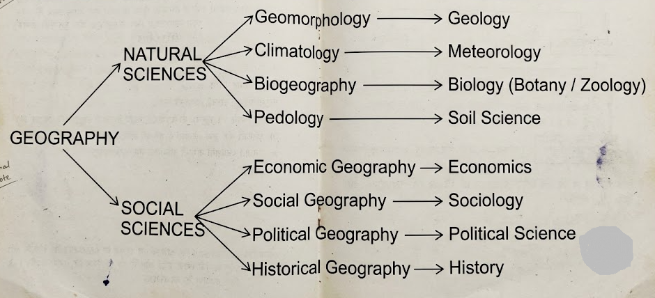
Interface with Natural Sciences: Physical geography interfaces directly with Earth and environmental sciences. Geomorphology relies on geology; climatology borrows principles of thermodynamics from meteorology; biogeography is rooted in ecology, botany, and zoology; and pedology bridges soil science with geography.
Interface with Social Sciences: Human geography engages with the humanities and social disciplines. Economic geography examines resource distribution using economic theories; political geography and geopolitics analyze borders and state power in dialogue with political science; and social geography explores spatial patterns of human behavior alongside sociology and anthropology.
The Unifying Spatial Dimension: While specialized disciplines examine what happens and how systems operate, geography uniquely addresses where phenomena occur, why they occur there, and how they spatially organize the terrestrial landscape.
3. Examine the place of geography in relation to the natural and social sciences. [GU 2024]
Answer: As Immanuel Kant observed, history organizes knowledge with respect to time (chronology), while geography organizes knowledge with respect to space (chorology). Geography occupies a pivotal nexus bridging the empirical methodologies of the natural sciences with the interpretive frameworks of the social sciences.
| Natural Sciences Interface | Social Sciences Interface |
| Geology & Geomorphology: Grounded in plate tectonics, stratigraphy, and petrology to explain landform evolution and physical structures. | Economics & Economic Geography: Applies spatial economic theories (e.g., location theory, trade dynamics) to resource extraction and supply chains. |
| Meteorology & Climatology: Incorporates atmospheric dynamics, heat budgets, and circulation patterns to analyze global and regional climates. | Sociology & Social Geography: Investigates spatial distributions of ethnicity, religion, class divisions, and urban segregations. |
| Hydrology & Oceanography: Examines drainage basins, fluvial mechanics, ocean currents, and global water regimes. | Political Science & Political Geography: Explores boundary delimitation, sovereignty, geopolitical conflicts, and electoral mapping. |
By maintaining this dual footing, geography provides a holistic framework essential for addressing complex global challenges, including environmental degradation, regional disparities, and sustainable development.
4. Explain the need and importance of spatiotemporal analysis in geography. [GU 2024]
Answer: Geographical phenomena are dynamic; no physical landscape or human settlement remains static. Spatiotemporal analysis integrates both space and time, making it fundamental to geographical inquiry.
Understanding Historical Evolution: Current settlement layouts, cultural geographies, and river channel morphologies cannot be understood without examining their historical development over decades or centuries.
Monitoring Environmental Change: Critical ecological issues—such as climate change, desertification, deforestation, glacier retreat, and sea-level rise—require multi-temporal tracking to quantify rates of change and assess environmental risk.
Urban and Regional Planning: Analyzing past demographic shifts and urban expansion enables planners to forecast future infrastructure demands, plan zoning ordinances, and balance land-use patterns effectively.
Advanced Geospatial Integration: Modern tools like Geographic Information Systems (GIS) and satellite Remote Sensing use time-series raster data to map land-use and land-cover (LULC) changes with high spatial and temporal accuracy.
Spatiotemporal analysis thus equips geographers with both retrospective insights and forward-looking tools for sustainable environmental management.
5. Explain how spatial patterns are formed as a result of spatial processes. [GU 2024]
Answer: In geographical analysis, spatial processes represent the driving mechanisms or dynamics, whereas spatial patterns are the observable, structural configurations left on the Earth's surface. They exist in a direct cause-and-effect relationship.
Fluvial Processes and Landform Patterns: Continuous physical processes of river erosion, transportation, and sedimentation generate identifiable geomorphic patterns—such as meandering belts, braided streams, oxbow lakes, and deltaic networks.
Migration Processes and Settlement Patterns: Socio-economic migration from rural peripheries to metropolitan cores functions as a continuous spatial process. This yields distinct settlement patterns, ranging from high-density concentric urban cores to linear suburban developments along commuter corridors.
Industrial Agglomeration: Economic forces of agglomeration and supply chain optimization encourage manufacturing units to cluster linearly along major transportation arteries and near raw-material nodes.
Diffusion Processes: The physical spread of ideas, technological innovations, or infectious diseases follows spatial diffusion processes (expansion or relocation diffusion), which produce clustered or hierarchical distribution patterns over time.
Spatial patterns are therefore the structural manifestations of underlying physical, socio-economic, and historical processes operating across space.
6. Discuss the concept, types, and characteristics of geographic space. [GU 2024]
Answer: Geographic space is the foundational medium of geography, encompassing the three-dimensional surface environment where physical and human phenomena are distributed, interact, and evolve.
Types of Geographic Space:
Absolute Space: A geometric, unyielding container with fixed mathematical properties. It is measured objectively using absolute coordinates like latitude, longitude, and physical distance in meters or kilometers.
Relative Space: A dynamic, relational concept defined by connectivity, social interactions, travel duration, or economic cost. In relative space, two cities may become "closer" over time due to high-speed rail, even though their absolute physical distance remains unchanged.
Key Characteristics:
Spatial Heterogeneity (Variability): Geographic space is non-uniform; every location possesses unique topography, climate, culture, and resource endowments.
Spatial Interaction and Interdependence: Places in geographic space are interconnected through continuous flows of people, goods, capital, and information.
Dynamic Evolution: Geographic space is continually produced, reorganized, and altered through natural forces and human activities.
7. Distinguish between systematic and regional approaches in geography. [GU 2024]
Answer: The dual approaches to geographical methodology reflect different ways of organizing and analyzing spatial phenomena across the Earth:
| Parameter | Systematic (General) Geography | Regional (Special) Geography |
| Philosophical Basis | Nomothetic: Seeks to formulate universal laws, general theories, and global typologies. | Idiographic: Seeks to understand the unique, individual character of specific regions. |
| Pioneering Figure | Championed and popularized by Alexander von Humboldt. | Developed and systematized by Carl Ritter. |
| Unit of Study | Focuses on a single specific phenomenon across the globe (e.g., world climate belts, global distribution of iron ore). | Focuses on a demarcated territory and examines all its physical, economic, and cultural elements together. |
| Structural Division | Divided into sub-fields like Geomorphology, Climatology, and Economic Geography. | Divided into areal units like Macro-regions, Meso-regions, and Micro-regions (e.g., Geography of Northeast India). |
Both approaches are complementary: systematic geography provides the theoretical tools, while regional geography applies them to understand specific local contexts.
8. Discuss how the definitions of geography have evolved across different eras.
Answer: The definition of geography has continuously expanded alongside advancements in scientific thought, philosophy, and technology:
Classical & Antiquity Period: Early scholars like Eratosthenes, Strabo, and Ptolemy defined geography primarily as the descriptive art and cartographic recording of the known world ("description of the Earth").
Nineteenth Century (Classical Modern Era): With Humboldt, Ritter, and Ratzel, geography transitioned into a rigorous scientific field focused on causal relationships and the reciprocal ties between nature and human societies.
Mid-Twentieth Century (Areal Differentiation): Richard Hartshorne redefined geography as the science of areal differentiation, focusing on describing and interpreting variable characters of the Earth's surface.
The Quantitative Revolution & Spatial Science (1960s onward): Driven by William Bunge, Peter Haggett, and David Harvey, geography embraced mathematical modeling, statistical hypotheses, and spatial geometry, reframing the discipline as a Spatial Science.
Contemporary Era: Modern geography integrates spatial science with sustainable development, critical human geography, geopolitical analysis, and geospatial technologies like GIS and Earth Observation.
9. Explain the role of Cause-and-Effect analysis in geographical studies with suitable examples. [GU 2024]
Answer: Modern geography is a causal science rather than a purely descriptive inventory. Cause-and-effect analysis explains why spatial patterns emerge, how they function, and what consequences they generate.
Physical Geography Example (Orography and Precipitation): The presence of the Himalayas (Cause) acts as a physical barrier to the Indian Southwest Monsoon winds, driving intense orographic rainfall across the plains of Assam and North India (Effect).
Human Geography Example (Alluvial Soils and Population Clustering): Flat relief, high water availability, and fertile alluvial soils (Cause) across the Indo-Gangetic and Brahmaputra plains directly drive high agricultural productivity and dense population clusters (Effect).
Environmental Geography Example (Anthropogenic Deforestation and Soil Loss): Unregulated hill-slope clearing and deforestation (Cause) trigger accelerated topsoil erosion, flash flooding, and downstream riverbed siltation (Effect).
Identifying these causal links helps geographers move beyond describing spatial layouts to formulating predictive models and targeted environmental policies.
10. Define spatial distribution and explain why distribution patterns vary across geographic space. [GU 2024]
Answer: Spatial distribution refers to the arrangement, density, dispersion, or concentration of physical and human phenomena (such as flora, minerals, populations, and industries) across the Earth's surface.
Spatial distributions vary significantly across geographic space due to several key factors:
Physiographic Variations: Mountainous regions, plateaus, and lowlands present distinct operational challenges, leading to uneven patterns in transport networks and human settlements.
Climatic Differentials: Temperature extremes and rainfall variability create stark spatial contrasts—such as high biodiversity in tropical rainforests compared to sparse ecosystems in arid deserts and polar tundras.
Uneven Resource Distribution: Natural assets like fossil fuels, mineral veins, and fertile soils are geologically and geographically localized, creating focused nodes of industrial activity and extraction.
Historical and Socio-Economic Drivers: Early access to infrastructure, capital concentration, and technological innovation have historically turned specific regions into economic hubs, leaving others less developed.